Sutter Buttes results from an inflection in the trend of the Sierras to Cascades uplifts. Starting with the 45 degree turn from the Sierras trend to the Mendocino west movement, at 40N latitude, the offset of Lunar by the solar earth tides (20.48 vs. 10.24mm/year) created an opening in the crust. This occurred after the polar wobble started shifting at the 16 m.y. age until the diversion was completed at the Eltanin event. The opening can be seen on Google Earth as a linear passing through the buttes, with opposing arcs on either side.


SUMMARY: COINCIDENCE OF SHEAR AND ROTATION OF THE CRUST HAS MADE A "QUADRUPLE CONJUNCTION" AT SUTTER BUTTES. THIS HAS HAPPENED DURING THE QUATERNARY, OR SINCE THE LAST SIGNIFICANT ASTEROID STRIKE- ELTANIN. I HAVE FOUND THAT THIS STRIKE HAS WIDESPREAD INFLUENCE, SINCE IT EVIDENTLY HAD MANY FRAGMENTS (WHILE PENETRATING THE ICE AT ANTARCTICA). THE SHEAR AND ROTATIONS MAY BE VIEWED AT THE EXTRUSIONS, AS SLICKENSIDES, PARALLEL FRACTURES, AND MULTI-ROTATIONS OF INDIVIDUAL PROMINENCES. SEVERAL MILANKOVITCH CYCLES HAVE CREATED ROTATIONS OF THE REGION, AND THEY CAN BE SEEN AT THE BASE OF THIS BLOG. AN ELLIPTICAL ROTATION OCCURS IMMEDIATELY TO THE SOUTH OF SUTTER BUTTES, AND SEEMS TO BE ROTATING A PORTION OF THE CRUST ADJACENT TO IT. THIS FEATURE IS QUATERNARY OR STARTING LATE PLIOCENE, AND SB CALCULATES .63 M.Y. AGE.
 ABOVE IS A GOOGLE MAP OF THE PACIFIC OCEAN TO SUTTER BUTTES, WITH SHEAR INDICATIONS FROM ROTATIONS SHOWN ON CONTINENTAL SHELVES. THIS PHOTO HAS SHEAR INDICATIONS WHICH ARE TOO SMALL TO BE OF VALUE TO INVESTIGATIONS FURTHER TO THE EAST IN THE CENTRAL VALLEY- THE LOCATION WHERE THE EXTRUSIONS OCCURRED.
WE WILL INVESTIGATE LARGER ROTATIONS TO FIND THE ONES APPROPRIATE TO DETERMINE THE STRAINS (THRUSTS AND LINEAR INDICATIONS OF MOVENENT) ASSOCIATED WITH THIS CONFLICT IN THE EARTH. GEOLOGISTS HAVE NOT BEEN ABLE TO FATHOM THIS ENTITY, AND WILL NOT BE ABLE TO UNDERSTAND IT WITHOUT RECOURSE TO A MODEL WHICH SHOWS THE MECHANICS OF MOVEMENTS. WE WILL TRY TO "FERRET OUT" OR PARSE THIS CONFLICT BETWEEN THE GREAT TRANSFORMS TO THE WEST AND THE MOVEMENTS AT THE EDGE OF THE SIERRAS-CASCADES REGIONS.

 SUTTER BUTTES- AS SHOWN ON THE INITIAL MAP- HAS MANY SHEAR AND ROTATIONAL FEATURES; IT LIES NEAR AND IS PART OF THE GEYSERS GEOTHERMAL ROTATIONAL SPIRAL NEAR THE MENDOCINO MOVEMENTS:
 Geysers field, CA is located at 38 degrees 47' 26N, 122 deg. 45' 21W


 SUTTER BUTTES, CA, IS PART OF A DEVIANT from THE SIERRAS- ALL THE WAY FROM MENDOCINO 40N PROTRUSION TO THE WEST AND CORIOLIS ROTATION ANOMALY
 The Sierras (NW-SE ORIENTED MOUNTAIN CHAIN, BETWEEN 34 AND 40N LATITUDES) ARE MOVING WESTWARD, BECAUSE OF THE INCREASED TIDAL DRAG ON THIS LATITUDE BAND. This occurs due to its greater protrusion into the atmosphere, where the TIDAL FORCE DRAGS ALL BULGES (SLOWS, RELATIVELY, ALL PROTRUSIONS) WESTWARD. Consequently, the segment of the CRUST between these latitudes is moving oppositely than the normal continental drag at the mantle top- which is to drag the crust east (with a simultaneous relatively slower movement of the top of the crust eastward). This normal eastward movement occurs because the mantle- being further from the MOON- moves somewhat faster than the crust (near 1 mm/year), and drags the crust at the lower boundary. As a result of all this, the segment between Los Angeles GARLOCK fault and Mendocino is moving westward (being higher in elevation)- creating several anomalies along the way. One of these is the angular change to the west at Mendocino (rotational) and another is the linear shown below:

A clue to the origin of SUTTER BUTTES IS SHOWN BELOW, WHERE TWO LARGER MOVEMENTS HAVE CREATED REACTIONARY CELLS WHICH WERE ROTATING AGAINST EACH OTHER, CREATING THE HEAT BY FRICTION NECESSARY TO CAUSE THERMAL UPLIFT AND EXTRUSION:
 A PRELIMINARY ANALYSIS OF THE FRACTURE TRENDS IS SHOWN BELOW. THIS WILL BE CHECKED IN THE FIELD, BY USING THE COMPASS TO MEASURE THE ANGLE, RELATIVE TO TRUE NORTH, MADE BY THE FRACTURES SEEN IN OUTCROPS (NOTICE THAT EAST VIEWS HAVE EITHER N-S OR NW-SE TRENDS):
SUTTER BUTTES IS SEEN BELOW AS A PART OF A LARGER ROTATION, WITH TWO CELLS ROTATING WITHIN THE VALLEY. THIS HAS CREATED THRUSTING ON A LARGE SCALE, AND A SINK WITHIN A CW-ROTATING CELL. This will have to be analyzed on a larger scale:

THE LARGER VERTICAL ROTATION WITHIN THE CRUST IS SEEN IN A DIAGRAM ON A STATE-WIDE VIEW, AND IT DIPS DOWN TO THE NORTH, WHILE BEING DRAGGED AT THE BASE BY THE MANTLE- WHICH MOVES TO THE EAST, DUE TO THE LESSER TIDAL INFLUENCE OF THE MOON:

THIS IS SHOWN DIAGRAMMATICALLY BELOW, AS A CROSS-SECTION OF VERTICALLY ROTATING EVENTS FROM MENDOCINO, CA TO OREGON:

THE GEYSERS ANOMALOUS AREA IS PART OF THIS PUZZLE. BELOW IS AN ANALYSIS OF THE FEATURE NEAR KELSEYVILLE, CA, WHICH PRODUCES STEAM FOR ELECTRICITY, AND WHICH IS SUBTLE IN ITS PRESENTATION. I HAVE ONLY PUT TRACES OF OBVIOUS ANOMALIES, AND WILL AUGMENT THEM AS WE INVESTIGATE THIS AREA SEPARATELY;


The solution of GEYSERS GEOTHERMAL SITE IS FOUND BY LOOKING AT A LARGER ENTITY- THE MOVING MENDOCINO LINEAR AT 40N LATITUDE WITH A CORIOLIS CELL ROTATING ABOUT IT, SIMILAR TO THAT FOUND FOR THE DISCOVERY FEATURE AT HURRICANE FAULT, UTAH:


 THE LARGE MENDOCINO CELL WITH A DIAMETER OF MORE THAN 500 KM, IS ROTATING SIMILARLY TO THE SMALLER ONE AT HURRICANE, UTAH SEEN IN AN ACCOMPANYING PHOTO- PRODUCING HEAT ON A MASSIVE SCALE (BUT NOT ENOUGH TO CREATE EXTRUSION).
Notice that the Sierras are moving westward, relative to surrounding parts of the CA state. They are also rotating CCW, so that the southern part moves 160 km, while the north part have moved about 100 km. How is this possible, when the whole range is moving westward? Indeed, the range is shoved by tidal forces acting on the high elevation mountains. This is a force created by the MOON'S TIDES, while the rotational force is one created by the spin of the EARTH. The boundary of the westward shove exists at 40N latitude, because of the termination of the equatorial bulge, EB. Above this latitude there is no large mountain range (until the Olympics are reached, and above that the Vancouver Island ranges). The latitudes between 40N and north Washington state have no high coastal ranges, hence are not dragged to the west (AS ARE THE SIERRAS), relatively.


BELOW IS AN "UNDOCTORED" VIEW OF THE CAPE MENDOCINO ACTIVE ZONE, WHERE CRUST SOUTH OF 40N SHEARS WESTWARD, AND NORTH SHEARS EASTWARD, YIELDING A CW ROTATION AROUND THE 40N EQUATORIAL BULGE TERMINATION, EB, WHERE MOVEMENT IS TO THE WEST FOR THE BULGE, AND RELATIVELY TO THE EAST FOR CRUST NOT HAVING A BULGE:

ANOTHER INTERPRETATION OF SUTTER BUTTES, AS TO HOW IT FITS IN THE GENERAL ROTATION AROUND THE 40N LATITUDE AND CIRCULAR SHEAR, IS SHOWN BELOW (THERE ARE SEVERAL INTERPRETATONS POSSSIBLE, BEFORE DOING THE FIELD WORK- TO FIND THE PARALLEL FRACTURE PATTERNS AND THE STRIATION-INDICATIONS OF MOVEMENT DIRECTION ON SLICKENSIDES):

NOTICE THAT I HAVE PLACED A CENTERLINE LINEAR AT THE APPROXIMATE CENTER OF THE CIRCLE OF ROTATION. I HAVE FOUND THAT THIS IS A WAY OF DETERMINING THE CENTER OF THE LARGEST SHEAR CIRCLE (YIELDING ITS DIAMETER). IN ADDITON, THIS SHOWS THE APPROPRIATE SHEAR CIRCLE, WHICH CAN BE FITTED TO THE FEATURE OF INTEREST:

ABOVE, I HAVE USED THE CIRCULAR PORTRAIT OF RIVERS AS THE PRIMARY TOOL FOR SHEAR INDICATIONS (RIVERS ARE FORMED PREFERENTIALY BY THE EASILY ERODED PATH ALONG ARCUATE SHEAR); SECONDARILY, WHEN THERE ARE NO RIVERS IN THE AREA OF INTEREST, I USE THE GOUGED ARCUATE TRACE IN VALLEYS AND LOWLANDS. ABOVE YOU CAN SEE THAT THERE ARE SEVERAL POSSIBLE PATHS; THIS IS WHERE FIELD WORK IS NEEDED TO FIND THE ACTUAL TRACE LEFT ON ROCK OUTCROPS, SUCH AS WITH PARALLEL FRACTURES, SLICKENSIDES, OR OBVIOUS THRUSTS.
 NOW YOU CAN SEE THAT THE SHEAR MOVEMENT ALONG THE 40N LATITUDE TO MT. LASSEN (WHICH IS NOT QUITE A STRAIGHT LINE- DIPPING DOWN AND THEN TRENDING NE-WARD ALONG THE EDGE OF B&R FAULTING IN NEVADA) INFLUENCES THE REACTIONARY CELL. THIS HAS FORMED THE SUTTER BUTTES AND GEYSERS. REMEMBER THAT THE EDGE OF EB REPRESENTS AN UNCONFORMITY, WHERE MOVEMENT ALONG THE SOUTH SIDE IS WESTWARD- WHICH SHEARS ROCKS TO THE SOUTH AS MUCH AS 160 KM ALONG THE GARLOCK FAULT AND 100 KM AT THE 40N BOUNDARY. THE DIRECTION OF ROTATION MAY NOW BE DETERMINED FOR RC. IT IS CW, WHEN THERE ARE NO INTERVENING BUFFER CELLS TO REVERSE THE INDICATIONS. CAUTION! THERE MAY BE SMALL CORIOLIS CELLS BETWEEN SUTTER BUTTES RC AND THE 40N LATITUDE TRACE! VIEWING ANOTHER POSSIBILITY FOR THIS COMPLEX AREA:
NOTICE THAT I HAVE CHOSEN TO USE THE DEFINITE ROTATION SEEN ON GOOGLE EARTH AS THE DRIVING FORCE FOR OTHERS- WHICH ARE INLAND.
PARKED BELOW ARE SOME PHOTOS, TAKEN 3 MAY, WHICH SHOW ANOMALIES FOUND IN THE FIELD, COURTESY OF MIDDLEMOUNTAIN FOUNDATION AND THEIR FIELD GUIDE. THEY HAVE NOTICED OUTCROPS WHICH YIELD INFORMATION CONCERNING THE ROTATION AND SHEAR OF SURFACE ROCKS:

 LATERAL AND VERTICAL SHEAR IS DEFINITELY OCCURRING IN THIS QUATERNARY FEATURE. BELOW ARE SHOWN SOME OF THE COMPLICATIONS OF THE DYNAMICS, WHERE EXHIBITED ARE THE INDIVIDUAL ROTATIONS AND SHEAR OF ONE OF THE LARGEST AND HIGHER PEAKS (NORTHEAST PEAK)- ONE AVAILABLE FOR INSPECTION BY HIKING INTO THE RUGGED RHYOLITIC AND ANDESITIC OUTCRTOPS:
  Below are my prognostications, BASED ON OBSERVATIONS MADE ON ACTIVE AND DORMANT VOLCANOES. WE WILL SEE HOW THEY PERTAIN AFTER VIEWING FRACTURES AND SLICKENSIDES IN THE FIELD:

 SHEAR INDICATIONS ARE OMNI-PRESENT, BUT SLICKENSIDES STRIATIONS AS BELOW ARE RARE. THE TRENDS SHOWN ARE MAINLY LATERAL, BUT HAVE A VERTICAL COMPONENT. EACH PEAK HAS ROTATED SEPARATELY WITH DISTINCT PATTERNS (INDICATING EXTRUSIONS OCCURRING THROUGHOUT TIME). THESE ARE SIMILAR TO GLACIAL SCRATCHES, WHERE HARD PARTICLES IN THE UNSEEN FACE IN THE PAST HAVE SCRATCHED AGAINST THE EXHIBITED OUTCROP. THE PARALLEL-NESS IS THE MOST CONVINCING FEATURE, SHOWING THAT THE SPIRALING OF VERTICAL-MOVING RHYOLITE HAS PRODUCED ITS TRACE:
  BELOW IS ANOTHER VIEW OF THESE STRIATIONS, WHICH DIP DOWN 20 DEGREES TO THE SOUTHEAST:
 I CLOSE FOR NOW WITH A VIEW OF THE NATURAL BEAUTY OF THE FOOTHILS OF SUTTER BUTTES. LET'S GET OUR FEET IN THIS AREA, LOSE SOME WEIGHT, UPLIFT OUR ASPIRATIONS, AND TOUCH NATURE, WITHOUT VANDALIZING IT. ENJOY FEATURES THAT ARE ALL AROUND US- SUCH AS THE BOTANY, GEOGRAPHY, GEOLOGY, AND ZOOLOGY OF THIS BEAUTIFUL LAND:
 SIMILAR TO GLACIAL PLUCKING, THERE ARE DEPRESSIONS IN THE OUTCROP FACE, WHERE HARD PROJECTIONS ON THE MISSING (ERODED) FACE HAVE DRAGGED A SOFTER PORTION OF THE REMAINING FACE. THIS CREATES A "PLUCKING" ACTION, WITH THE WEAKER ROCK REMOVED. FURTHER DOWN, "OWLS EARS" HELPS TO IDENTIFY THIS SE SUTTER EXTRUSION, WHERE SHEARING HAS CREATED FRACTURES ORIENTED E-W. THIS IS DIAGONAL TO THE ONES EXHIBITING THE SLICKENSIDES, AND INDICATES THAT THERE ARE DIFFERENT ORIENTATION OF STRESSES ON OPPOSITE SIDES OF THE EXTRUSION:
 ADDITIONAL INFORMATION IS SHOWN BELOW, WHERE A DEPRESSION OR SINK- RELATIVE TO THE SURFACE ON EITHER SIDE- OCCURS NEAR THE PERIMETER OF THE BUTTES. THIS WOULD BE THE CASE OF A CW ROTATION OF THE QUATERNARY EXTRUSIONS AS THEY CONTINUE TO SINK (SPIRALING DOWNWARD):
PERIPHERAL INFORMATION:
The regional tectonics of Northern California yields background from which the Sutter Buttes departs. Below are shown some photos from foothills near Auburn, which is 50 km to the south and east:

ASSESSMENT OF SUTTER BUTTES-MENDECINO GEOTHERMAL INITIATION INVESTIGATION
My original assessment of the “FIT” of the Sutter Buttes into a world-wide dynamics, due to Coriolis Rotation, Equatorial and Sierras Bulges Termination, and Drag of the Earth’s Crust with Mantle Differential velocity is shown below. Although I have not found anything to contradict my preliminary portrait, I have not done enough fieldwork to make positive conclusions.
Here is the initial assessment, found from Google Earth, from which all of the observations concerning Sutter Buttes were derived:
1. Rotation of the CRUST, laterally, due to Coriolis forces around the Mendocino 40N Latitude can be seen at Cape Mendocino, as a jutting of siltation at the Pacific Ocean continental slope- south of 40N. North of Mendocino there is less protrusion of the slope, and the movement is opposite to that south of 40N. Combination of the two opposite movements (shearing) creates a CW rotation about 40N, and this drags the Crust on either side to create rotations, or REACTIONARY CELLS, RC, of various diameters;
2. The Equatorial and Sierras Bulges terminate at 40N latitude, yielding several phenomena:
A. Unconformity of formations below and above 40N (laterally, latitude-wise) and slickensides at the boundary- indicate that there is continual shear of the Crust at the 40N bulge terminations (I have retrieved a rock sample from the Cape, photoed and shown in an earlier missive in this blog);
B. There is creation of earthquakes, lateral movement, and HEAT OF FRICTION, as the two segments move alongside each other;
C. Westward, movement on the south side of 40N creates drag of the Crust there, and this initiates large diameter extensions and translations- the largest of which continues eastward to create rhyolitic extrusions from the common border of ID, NV, and UT to Yellowstone, Simultaneously, there is a movement of the Sierras westward, and this results in an extension (A PULLING APART) of the Basin And Range, B&R, to allow Mammoth Lakes Geothermal area to form and to create extrusion of violent rhyolitic emissions each million years or so (for a total of 13 sets of basins and Yellowstone-type extrusions until the Rocky Mountains are reached). It is assumed that the extension continues eastward, because of the protrusion of N-S trending mountain ranges which result in new extensions for each new protruding range;
D. Rotation of the RC south of 40N creates heat sufficiently to cause extrusion at Sutter Buttes, and subsequently Geysers geothermal field; this is a Coriolis cell of at least 100 km in diameter; and,
E. Extension of the B&R, with simultaneous rotation of the Sierras- causes the Central Valley to sink while the Sierras continue to rise.
3. The North Pacific basin exhibits shear along latitude lines, principally because the deep water absorbs the tidal effect, compared to continental crust being irregular and exhibiting consequent irregular movements. The crust is thin under oceans, compared to that under continents, consequently shear lines in ocean bottoms are more regular (along latitude Ines for this part of the Pacific). Other ocean basins have associated bulges and do not portray the simplicity as does the North Pacific (Sahara bulge for the Atlantic, islands for the South Pacific, PTr strike for the Indian Ocean, and fragmentation of the Arctic; and,
4. Yellowstone geothermal phenomenon occurs due to extension, beginning in the Miocene after the Sierras instituted extension (AFTER SUFFFICIENT RISE OF THE MOUNTAINS). For each basin, with its accompanying rhyolitic extrusion at the northern head of each valley, there is eastward movement of the B&R, as a new protruding N-S linear range institutes new tidal shove to the west. This hints that rise of the Sierras began in the Oligocene, similar to the movement of the basalt vents westward from the Rio Grande rift (around the south and SW edges of the Colorado Plateau).
CONSEQUENTLY, THE RISE OF THE SIERRAS, THE UPLIFT OF THE COLORADO PLATEAU, THE FORMATION OF THE WASATCH LINE, THE INITIATION OF THE B&R, AND THE ROTATION OR BOTH B&R AND CP ARE INTER-CONNECTED (PROBABLY ORIGINALLY INSTITUTED BY THE INSTABILITY OF THE WOBBLE CREATED BY THE KT STRIKE IN YUCATAN).
BELOW IS A MAP OF THE WESTERN USA, WHERE THE FEATURES LISTED ABOVE ARE SHOWN. NOTICE THAT EVERYTHING IS INTER-CONNECTED, SHOWING THAT THE B&R, THE CP, THE SIERRAS, AND THE CASCADES FORM ROTATIONS WHICH EITHER HARMONIOUSLY ROTATE OR ELSE THEY CONFLICT- CREATING VULCANISM, GEOTHERMAL AN0MALIES, OR RECOGNIZABLE GEOLOGICAL FEATURES.

Sutter Buttes can be used to affirm the above preliminary assessments, if the following features can be shown:
a. That the entire SB outcrop can be shown to be rotating CW (cooling and shrinking vertically) NOW, COMPARED TO CCW ORIGINALLY;
b. That the present rotation fits into a general CW rotation of the entire circular cell from SB to the Mendocino 40N location;
c. That the N-S linear is a thrust, west of SB, with opposing shear on either side of this Kelseyville, CA (39N 122 22W) STRAIGHT-LINE feature; and,
d. That slickensides can be found for the circular feature, at least for four separate sides and locations.

Above is another possibility of the various Coriolis circular features, connected with the 40N latitude- Mendocino shear zone and rotation. Notice that some drainages turn southerly below the 40 latitude. This is expected, since the Sierras and Equatorial bulges terminate there, and there is discontinuity between the Crust to the north and south of this more-slowly moving Crust in the south (compared to the north, where there are no large mountain ranges, such as the Sierras, or EB to slow the Crust- relative to the faster-moving Mantle).
This is an extremely complicated zone, where EB, Sierras bulges, Vulcanism related to vertical rotation (oriented N-S), contrast of thickness of continental vs. oceanic Crust, and rotation of the Sierras CCW all interact to produce many circular portraits of rivers, lakes, shear valleys, thrusts along I-15, and in the foothills.
However, I am confident that after considering all of the possible rotations and interactions, that I can sort this out to produce the most likely scenario creating vulcanism, thrusts, shear between Coriolis cells, and lateral folds.
A critical factor is that of finding in the field the various slickensides, parallel fracture pattern, concrete slab lateral shear indications, and the direction of shear on four (or at least 3) sides of Sutter Buttes. I have found that Google Earth photos are excellent for determining the circular features in the crust, but that the direction of spin, or rotation of cells may be diagnosed to be backwards without field evidence. Even then, cat steps or claw marks may be difficult to diagnose. But one rule has proven to be inviolable: rising features (salt domes, active volcanoes, and uplifting regions) rotate CCW, while sinking crust (basins, depressions and sinkholes) rotates CW.
THE REGIONAL TREND OF SHEAR AND STRESS IS NW-SE, SIMILAR TO THE COASTLINE OF WESTERN CA AND OF THE SIERRAS (THEY ARE MOVING WESTWARD, WHILE ROTATING CCW):


Above and below are photos taken near the DEADMAN CREEK AND ITS INTERSECTION WITH A LARGER STREAM:


Incidentally, this appraisal has yielded information necessary to solve the SUTTER BUTTES ANOMALY- which is not understood by field geologists. I now see that there is another transform south of the 40N Mendocino location which bears on the rotation, shear and extrusion of basalts at this SB location.


I have analyzed the EO strike, after having done hiking and investigation of the 41 m.y. and younger movements. This age is taken from a major transform in the North Pacific Ocean, where the age has been measured for the Kimmei seamount at the focus of the transforms. Although this age is older than the EO boundary at 34 m.y., it seems that fossil evidence occurs somewhat later than the mechanical action of a strike. Consequently, I have re-analyzed the British Columbia antipode found for the EO strike in the Indian Ocean. There is strong evidence from transforms being diverted in a deep part of the basin- 3 miles depth- that there was a strike at the oppositely-located position of the crust at 58S 68E location (French Southern Islands).


Inspection of the EO antipode in BC and Alberta indicates that there was spiraling of a basin, and that likely the orientation of features in the USA would react to this movement. I have plotted the path of the reaction, as indicated by the 41 m.y. transform at 40N and Mendocino, CA; this indicates that the shear was accelerated by the event- noticed and measured for age at the Kimmei seamount. My general assessment for asteroids and their path as shown by transforms in the ocean basins, is that the STRESS IS PRESENT IN ADVANCE OF THE ASTEROID, BUT THAT IT IS ACCELERATED (CREATING STRAIN OR MOVEMENT ALONG TRANSFORMS) BY THE STRIKE.
Notice that there are concentric circles of shear- as evidenced by patterns of river valleys and faint traces which have been “farmed over” leaving circular indications. The region presents a pattern somewhat similar to that of the KT strike and the Gulf of Mexico: there is basin to the right of the strike and another east of the antipode (in both cases).
Incidentally, this appraisal has yielded information necessary to solve the SUTTER BUTTES ANOMALY- which is not understood by field geologists. I now see that there is another transform south of the 40N Mendocino location which bears on the rotation, shear and extrusion of basalts at this SB location.
NW USA IS INFLUENCED BY THE EO STRIKE OF 34-41 M.Y. THROUGH OREGON (FOSSIL EVIDENCE), NORTHERN CA, AND WA. THERE IS VERTICAL ROTATION OF THE CRUST FROM CA (MT. LASSEN) TO THE CANADIAN BORDER- WHERE THE ANTIPODE OF EO IS MOST INFLUENTIAL. THIS IS SHOWN BELOW BY GOOGLE PHOTOS AND BY DIAGRAM LATER:
BY DIAGRAM, FOR GENERAL AS WELL AS LOCAL ROTATIONS, VERICALLY AND HORIZONTALLY:

 ASSESSING THE LARGER PICTURE OF THE MOVEMENTS FROM MENDOCINO 40N LATITUDE TO PIONEER RIDGE TO THE SOUTH, THERE ARE TWO SIGNIFICANT (LARGE DIAMETER SHEAR CIRCLES) MOVEMENTS TOWARD THE GEYSERS GEOTHERMAL FIELD. "ODDS ARE" THAT THERE ARE TWO INTERFERING SHEAR CIRCLES (LATERAL, WITH HORIZONTAL DISPLACEMENT) AT THE SHALLOW CRUST NEAR KELSEYVILLE, CA. WE WILL PROCEED FROM THESE, TO SEE WHETHER THIS LEADS TO THE PLIOCENE EXTRUSION AT SUTTER BUTTES:


SOLVING THE ENIGMA OF SUTTER BUTTES EXTRUSION IS MADE EASIER BY USING A PROXY: THE OCCURRENCE OF A SIMILAR EXTRUSION, WHICH IS MORE EASILY HIKED, PHOTOGRAPHED, AND VIEWED AT CLOSE HAND. THE PROXY IS LEEDS VOLCANO- A NOT-YET-DOUBLY-EXTRUDED PLEISTOCENE BASALTIC VOLCANO. I CAN DRIVE TO THE EDGE OF THIS BASALT OUTCROP AND HIKE IT IN A MORNING. IT HAS MANY SIMILARITIES: A SPLIT CONE, WITH AN EASILY DISCERNED ORIGINATION SITE, OBVIOUSLY CW-ROTATING AND COOLING ARCUATE FEATURES, AND GOUGE ZONES, WHICH ARE BEING DISCOLORED WITH THE CHEMICAL WEATHERING. THIS IS SEEN IN THE 2ND PHOTO DOWN, BUT FIRST, VIEW A SMALLER YET SHEAR ZONE IN THE NE CORNER (WHICH IS THE CASE FOR LEEDS, BUT A DIFFERENT ORTHOGONAL BLOCK) OF SAND MOUNTAIN-HOLLOW- TO THE SOUTH OF THE VIRGIN RIVER:

LEEDS PRESENTED IN A DIFFERENT MAGNIFICATION:

NOW THAT YOU ARE "PRIMED" WITH THE ASSOCIATION OF NE CORNER OPENINGS AND SHEAR FEATURES, VIEW SUTTER BUTTES AS A NE CORNER FEATURE:

SOLUTION TO SUTTER BUTTES OCCURRENCE: INTERFERENCE OF 2 SHEAR CIRCLES
I have found that there is a ratio between the separation of shear linears and the diameter of the arc creating the GRID. It is 50:1, where the relation is developed by the present stress state created by the latest asteroid- the 2.15 m.y. ELTANIN event.
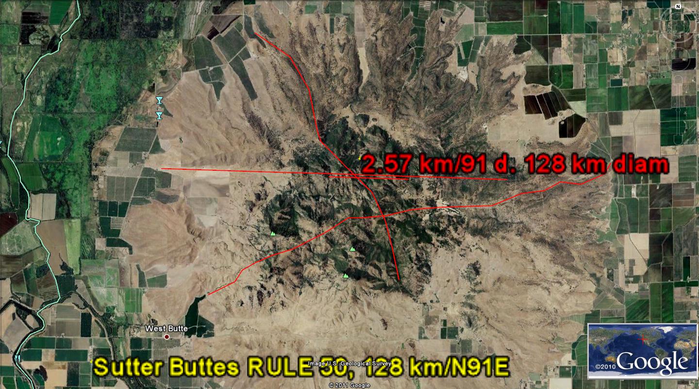
The case of Sutter Buttes has several parallel gridlines or linears, on a scale where they appear to be straight lines, but which actually are curvilinear on a larger view. The curvilinear feature is a circle, which usually incomplete (presently forming), and which denotes the rotation of a reactionary cell, RC. RC may be a Coriolis cell, or it may be “DRAGGED” BY SOME LARGER MOVEMENT. Sutter Buttes has a common linear oriented toward the Geysers geothermal field, which is shown below:
Sutter Buttes and Geysers 128 km radius
The circumference is not so obviously visible, and it is subverted by other dynamics away from the arcs shown, but nevertheless is operative for the Sutter case. Below is the 2nd shear circle, found by photo of the contrasting parallel gridlines:


THERE ARE FOUR ARCUATE FEATURES INFLUENCING SUTTER BUTTES: 2 TO THE NORTH-SOUTH AND 2 TO THE E-W. THESE WOULD NOT BE NOTICED BY GEOLOGISTS, SINCE YOU MUST HAVE THE CRITERIA IN ADVANCE TO FIND THEIR LOCAL INFLUENCE. THE SHEAR AND ROTATION ARE PARTLY DETERMINED AS A REACTION TO THE ROTATION OF MT. SHASTA (WHICH IS IN TURN PROBABLY ASSISTED BY THE ELTANIN STRIKE OF 2.15 M.Y. AGE. DON'T ATTEMPT TO USE THIS RELATION FOR OLDER STRIKES, SINCE THE MULTIPLES WILL BE DIFFERENT. FOR EXAMPLE, THERE IS A 6 M.Y. STRIKE WHICH RAISED CEDAR BREAKS, AND ITS TIME CYCLE HAS ANOTHER MULTIPLE. CONCENTRATE ON THE ONE AT HAND- THE INTERFERENCE OF FOUR ROTATIONS WITH EACH OTHER, ALL OF WHICH CAN BE SEEN AS PARALLEL FRACTURES, (AND LATERAL FAULTING) ON DIGITAL PHOTOS OR ON GOOGLE EARTH.


THE LATERAL SHEAR HAS MOVED WESTWARD WITH TIME, SINCE BOTH SUTTER AND MT. SHASTA HAVE COOLED (ROTATING CW), AND THRUSTING HAS BEEN ACTIVATED TO THE WEST- DRAGGED BY THE MENDOCINO MOVEMENTS. HENCE THE HEAT IS BEING GENERATED BY A NEW SET OF ROTATIONS:

Sutter Buttes and Geysers 128 km radius
The circumference is not so obviously visible, and it is subverted by other dynamics away from the arcs shown, but nevertheless is operative for the Sutter case. Below is the 2nd shear circle, found by photo of the contrasting parallel gridlines:


 THIS ANALYSIS HAS NOW INCORPORATED "MILLAKOVITCH CYCLES" AND THE TWO THAT ARE OF MOST CONCERN ARE CALCULATED TO HAVE STARTED IN LATE PLIOCENE, OR AT THE BOUNDARY OF QUATERNARY:
Applying THE LATEST DISCOVERY of www.Quadransphere.blogspot.com we are now able to measure the AGE OF INDIVIDUAL SHEAR ROTATIONS AT SUTTER BUTTES (there are many, and there are some CAVEATS TO THE CALCULATIONS). EARTH TIDES NORMALLY ARE 20km/m.y. for regions where PARALLEL GRID LINE DISPLAYED (EASILY VIEWED IN OCEAN BASINS). The FIRST CAVEAT
1. IS THAT VOLCANOES OCCUR WITHIN AN ELLIPTICAL ROTATION, CAUSED BY GRAVITATIONAL DEVIATION WITHIN THE SOLAR SYSTEM. WHENEVER THE LARGE PLANETS "ALIGN", THE ELLIPTICAL SHEAR FEATURES ARE ACCENTUATED.

LEEDS VOLCANO HAS 2 SEPARATE DOMES WHICH WERE BELCHED BOTH WITHIN A FEW THOUSAND YEARS; THESE ARE MARKED BY A DIVIDING LINEAR, WHICH IS THE LOCATION OF THE ORIGINAL LINE SEPARATING THE SOLAR EAST TIDES FROM THE LUNAR WEST TIDES. I AM EXPLORING THIS FEATURE, WITH THE INTENT TO FIND WHETHER THE LINEAR OPENED THE CRUST ALL THE WAY TO THE MANTLE- ALLOWING NORMALLY HOT BASALT TO SIMPLY EMERGE BY BUOYANT RISE OF THE LIGHT MAGMA. THIS IS THE SIMPLEST CASE WHERE BASALT RISES UPON ENCOUNTERING AN OPENING (PIPE OR CONDUIT) TO THE ATMOSPHERE. THE DIVIDING LINEAR WOULD NOT BE A CURVILINEAR, BUT WOULD BE A LIMITED EXTENT LINEAR, CREATED BY THE 45 DEGREE TURN TO THE LEFT OF THE VIRGIN ANTICLINE (CORRELATED WITH THE 2 M.Y. ELTANIN EVENT OR LATER):

THIS IS SHOWN IN OBLIQUE VIEW, SO AS TO ALLOW A 3D ANALYSIS.

SUTTER DOES NOT SHOW AN ELLIPTICAL FEATURE, AND THIS MEANS THAT THE 2ND LARGE EXTRUSION HAS NOT YET OCCURRED. IT WILL LIKELY OCCUR WITHIN 1 M.Y. OF THE ORIGINAL, AS FOUND ON THE HAWAIIAN ISLANDS, AND PROBABLY ERUPT ON THE SOUTH SIDE OF SUTTER BUTTES, WHERE THERE IS PRESENTLY A RISE AND ACCOMPANYING GAS FIELD. SEE THE GOOGLE PHOTO BELOW:
2. USE OF 20KM/M.Y. FOR ELLIPSES ENTAILS ERRORS, OF TWO TYPES:
A. ELLIPSES CONTAIN AT LEAST 2 ROTATIONS, PERTAINING TO THE AXIAL AND PRECESSIONAL CYCLES OF 40 AND 25 M.Y. THE 20 DIVISOR TO AGE CALCULATIONS CAN ONLY BE USED FOR THE AXIAL, WHICH HAS A REGULAR DISPLAY OF 40 K.Y., OR FOR HARMONICS OF THIS REGULARITY;
B. THERE ARE NO CONSTANT GRID LINE SEPARATIONS FOR VOLCANOES, THRUSTS AND REBOUND.
3. WHENEVER A "TOO LARGE" DIVISOR OF 20 IS USED, THE AGE CALCULATION WILL BE LOW IN NUMBER OF YEARS. TO FIND THE APPROPRIATE DIVISOR, ONE MUST GO THROUGH THE CALCULATIONS TO OBTAIN THE APPROXIMATE DIVISOR, AND THEN ADJUST THE CALCULATIONS APPROPRIATELY. FOR EXAMPLE, FOR REBOUND AND THRUST FAULTING, AS AT WHIDBEY AND SAN JUAN ISLANDS, THE DIVISOR VARIED FROM 10 FOR THRUSTING, DOWN TO 1 FOR UNLOADING OF ICE (MASS RE-DISTRIBUTION);
4. IT IS LIKELY THAT THE DIVISOR IS 10 FOR SUTTER BUTTES, AFTER ALL MY CALCULATIONS ARE ADJUSTED FOR "CHATTER" OCCURRING FOR VULCANISM, REBOUND, AND THRUSTING. CONSEQUENTLY, THE AGES CALCULATED ARE ERRONEOUS BY A FACTOR OF 2 (1/2 M.Y WOULD MORE LIKELY BE 1 M.Y).

Another way of ANALYZING Sutter Buttes involves the POLYGON EXHIBIT. I have found that most of what I have CALCULATED from ARCUATE ROTATIONS consists of a series of "JERKS" large and small. The SIMPLEST CASE exhibits these LINEARS (as with LATERAL THRUSTING) in a COMPLETE POLYGON. Sutter Buttes has these presented excellently on the SW, W, and NW sides, but incompletely on the NE and SE sides. This indicates that the 3.8 m.y. development is not complete, and the NEARBY GEYSERS GEOTHERMAL FIELD tells a similar story. Look at the ON-GOING MOVEMENT and it is clear that the DIAMETER of the POLYGON can be determied, but not the entire polygon. With this measurement, the approximate PERIMETER can be used to calculate the APPRROXIMATE AGE= PERIMETER/tidal rate of that from trigonometry of 10-12 degrees from DUE E-W:

The 2 EARTH TIDAL LINEARS are almost parallel (within 2 degrees by the compass), and yield a measure of CONFIDENCE to the procedure:

Also, the ORTHOGONAL TRACE overlies a faint DIVIDER of the EXTRUSIONS:

What can we determine from the UNFINISHED POLYGON- the MISSING LINEARS?

Above Google photo indicates that the NE side of the polygon (which rotates at a smaller RATE= 14mm/year) is in DEVELOPMENT, partly since there is an INTERFERENCE from other SOLAR MASSES (2 ratio pertains to Mars, 1.62 to Venus, and 2.5 to Jupiter).
LEEDS VOLCANO HAS 2 SEPARATE DOMES WHICH WERE BELCHED BOTH WITHIN A FEW THOUSAND YEARS; THESE ARE MARKED BY A DIVIDING LINEAR, WHICH IS THE LOCATION OF THE ORIGINAL LINE SEPARATING THE SOLAR EAST TIDES FROM THE LUNAR WEST TIDES. I AM EXPLORING THIS FEATURE, WITH THE INTENT TO FIND WHETHER THE LINEAR OPENED THE CRUST ALL THE WAY TO THE MANTLE- ALLOWING NORMALLY HOT BASALT TO SIMPLY EMERGE BY BUOYANT RISE OF THE LIGHT MAGMA. THIS IS THE SIMPLEST CASE WHERE BASALT RISES UPON ENCOUNTERING AN OPENING (PIPE OR CONDUIT) TO THE ATMOSPHERE. THE DIVIDING LINEAR WOULD NOT BE A CURVILINEAR, BUT WOULD BE A LIMITED EXTENT LINEAR, CREATED BY THE 45 DEGREE TURN TO THE LEFT OF THE VIRGIN ANTICLINE (CORRELATED WITH THE 2 M.Y. ELTANIN EVENT OR LATER):
THIS IS SHOWN IN OBLIQUE VIEW, SO AS TO ALLOW A 3D ANALYSIS.
SUTTER BUTTES, CENTRAL VALLEY, CA results from an opening created by Lunar westward vs. Solar eastward tides:
Photo above shows the arcuate presentation of shear rotations created by EARTH TIDES. These commenced after 3 m.y. (probably related to the ELTANIN EVENT), and have pulled the crusat apart at a rate of 10.24 mm/year, NET. The lunar rate of 20.48 is offset by the solar pull to the east, which is exactly half of the normal westward tidal- as developed by the BINARY THEOREM. This phenomenon occurs ONLY in the NE quadrant of a rotating block of crust, and has been observed for all quadrants I have examined: Gulf of Mexico, Sand Mountain, UT, Offshore channel islands, CA, Loihi, HI offshore Hawaii, and the Aleutian Spiral.
Earth Science, in Quadra-meter
The Globe from space, truly’s a beauty-
(which, thought in field, is naught but duty)-
But requires a search to de-ossify,
With great renown, a bone to classify.
But seen as ART, Makers assure,
The whirls and mounds are Beauty pure;
They spiral around, creating Fire,
Which to the Aesthetician can inspire
The lowly worker on the ground
To search the rigid rocks profound,
For secrets more than grains- mundane
(Which spread their dust across the plain).
The Orb’s a sphere, and almost clean;
It daily rectifies defilement mean,
And eliminates the intent of greed
To accumulate materialistic Deed
To that which fills a constant need
In lieu of fragrance - Rose and seed-
Giving LIFE another chance to breed
For Beauty, Poetry, ’n Art indeed.
Poets return to IDEAS beautiful
Away from Geology’s Do t’fool;
The easy way’s to stop the budget
Then there’s no longer need to fudge’t.
Harold L. Overton
THIS WILL BE AUGMENTED AS ADDITIONAL INFORMATION IS FOUND IN THE FIELD.
No comments:
Post a Comment