
CURVACEOUS CORIOLIS CELLS
By Helical Hal
After documenting this concept for two years, I will now make this more concise in terms of simple description. This is not mathematical, since all the academics with their derivations have not been able to see this presented in the EARTH’S CRUST. They have it for the atmosphere, and THEN later for the circulation of ocean waters, but the GEOLOGY CULTURE does not have this in their nomenclature.
Above is shown a Coriolis Cell found in the Aleutian Chain, part of Alaska:
This rotating cell is being dragged by the SW-ward moving island chain, which is itself a portion of a larger Coriolis rotation. GPS measurements have affirmed that the velocity vector points to the SW along this ALEUTIAN chain, as shown in the following EARTH DIAGRAM:

Meteorology has shown that Coriolis cells are responsible for a good portion of the earth’s weather. Low pressure (stormy, AND RISING AIR) rotating cells in the atmosphere circulate CCW in the northern hemisphere, while High pressure cells of good weather (with descending air- which is compressed, and therefore warm) rotate CW. In the southern hemisphere, cells move in a opposite direction and that is because the gradient of THE EARTH'S CRUSTAL velocity decreases as southern latitude becomes larger. The velocity of the EQUATOR, referenced to the poles, is 900 nautical miles each hour (15 degrees of the earth’s 360 degree circular configuration) and this is equivalent to about 1000 statute miles of 5280 feet each. The equivalent 1 minute of arc of longitude is the same as 4 minutes of time- that is, one nautical mile is traversed referenced to the sun in 4 minutes by the earth’s spin. You remember that a TIME ZONE is 15 degrees in width, and that there are 24 of them in the circle of the earth, for each day (24x 15= 360, and 60 nautical miles/ degree longitude x 360= 21,600 nm, which is the approximate circumference of the earth).
The Aleutian Spiral is easy to see (there are few obstructions in the ocean, and the crust is thin for easy movement) and it is represented in the atmosphere occasionally by an equivalent rotation in the clouds:

The reason why the atmosphere is performing similarly to features in the oceans is that obstructions or bulges in the earth's diameter influence both movements. The main difference for the two exhibits is due to the drastic difference in viscosities of the two media: Crustal rock has viscosity on the order of 100 million times that of AIR- which IS MUCH LESS THAN 1 centipoise (that for water at room temperature). The crust of the earth moves exceedingly slowly, on the order of 1 mm/year, for Coriolis rotations- referenced to and slower than the MANTLE. The atmosphere is rotating on the order of miles/hour, but they both have the same impetus- slower movement on the side of the cell further from the Equator, compared to that on the closer side. For an example of rotation or spiraling in the continental crust, one is shown below for the Zion highlands, Utah- which represents a rise of about a mile above surrounding St. George basin:

ANOTHER IS SHOWN FOR THE HONEYMOON TRAIL ROAD, AT THE ENTRANCE TO A CANYON THERE:


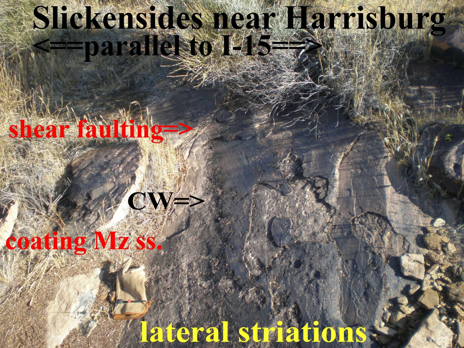
LATERAL ROTATIONS ARE MOST EASILY SEEN (ABOVE) VIA THE STRIATIONS ON SLICKENSIDES- WHICH ARE FOUND WHERE SIDEWAYS FAULT MOVEMENT OCCURS, SUCH AS WITH THIS EXAMPLE (BELOW) ALONG THE GREAT LATERAL B&R FAULT BY FREEWAY I-15, AT LEEDS:

 THESE CLASSIC SLICKENSIDES CAN BE SEEN WITHOUT GETTING OUT OF YOUR AUTO, ON HIWAY 9, ON THE EAST SIDE, HEADING TO ZION NP, IN THE GRABEN SWITCHBACKS JUST ABOVE LAVERKIN TOWN:
 BELOW IS A GOOGLE PHOTO OF THE ZION-GRASS VALLEY REGION, SHOWING THE TWO ROTATING CORIOLIS CELLS:
BELOW ARE DIGITAL PHOTOS OF HIWAY 9, LEADING UP THE SWITCHBACKS INSIDE THE LAVERKIN GRABEN- SHOWING THE MAINTENANCE NECESSARY TO OFFFSET THE SINKING AND SHEARING ONGOING ON THE ASPHALT ROAD. NOTICE THAT THEY ALIGN WITH THE GRABEN WALLS, BUT MOST OF THEM CROSS THE HIGHWAY. THIS INDICATES THAT THERE IS RENEWED SINKING TO THE NORTH, OF THE GRABEN IN THIS EXTENSIONAL REGIME:

 NOTICE THAT EVEN ON THE SHOULDER, WHERE THERE IS NO TRAFFIC, THAT THERE ARE LONGITUDINAL CRACKS ALIGNED WITH THE GRABEN AXIS:

CLOSEUP, THE SINUOUS NATURE OF THE ZION SPIRAL MAY BE SEEN:
 FINALLY,I HAVE ENDED WHERE I STARTED, 2 YEARS AGO, AT THE GRABEN WALLS WHICH PRESENT SUCH REMARKABLE SHINY SLICKENSIDES. I HAVE MADE A COMPLETE CIRCLE AROUND THE GRASS VALLEY CORIOLIS CELL- FINDING THAT IT ROTATES IN HARMONY WITH THE RISING ZION CELL.
WHICH DRAGS THE OTHER? DOES THE RISING ZION CELL, WHICH IS SMALLER, DRAG GV, OR IS IT MORE LIKELEY THE REVERSE? EVEN THOUGH GV IS LARGER AND MOTIVATED BY THE DRAG OF Hf, IT IS YOUNGER IN TIME (FURTHER WEST AND NEAR 1 MILION YEARS AGE FOR IVINS KNOLL), AND HAS VULCANISM STRADDLING Hf. THIS DEMONSTRATES THAT GV DOES NOT HAVE THE MAIN PART OF CP RISING BELOW IT. WE'LL SAVE THIS THOUGHT UNTIL WE CAN SOLVE THE PUZZLE OF IRON MOUNTAIN, SUPER-HIGH CEDAR BREAKS, AND THERMAL INFLUENCES OTHER THAN EXTRUDING MINOR VENTS.

PHOTOS BELOW ARE FOR REVIEW AND "MULLING OVER:"


This demonstrates that NOT ONLY IS THE ZION UPLIFT SPIRALING, BUT IT IS SYNCHRONIZED WITH THE GRASS VALLEY CELL. THESE ARE ROTATING IN OPPOSITE DIRECTIONS, CW (SINKING) FOR GV, AND CCW FOR THE ZION SPIRAL (RISING), SIMILAR TO TWO GEARS IN YOUR AUTO TRANSMISSION CASE (NOT GRINDING, AS WOULD OCCCUR IMMEDIATELY BEFORE THE GEARBOX CREATES HEAT AND FAILURE). The primary motivation for this is probably due to HEAT OF RADIOACTIVITY, YIELDING AN EXPANDING CRUST WHERE THE DAUGHTER PRODUCTS ARE NUMEROUS. ZION IS RISING, CREATING DRAINAGE TO THE WEST AND THE ST. GEORGE BASIN. THIS BASIN IS SURROUNDED ON ALL SIDES BY MOUNTAINS, WITH THE ONLY OUTLET BEING THE VIRGIN RIVER GORGE.
ONCE THE ZION FEATURE STARTS RISING, IT CREATES MORE HEAT BY THE BRITTLE FRICTION OF RISING (CCW) MAGMA SHEARING WALL ROCK. THIS CONTINUES EVEN AFTER THE MAGMA CEASES TO RISE, SINCE THERE IS BRITTLE FRICTION, BY REVERSE CW SHEARING OF THE SEDIMENTARY COLUMN AGAINST NEARBY ROCK (WHICH IS NOT ROTATING) IN THE SINKING GRASS VALLEY CELL OR REGION. INCIDENTALLY, THIS IS NAMED FAULT REVERSAL BY VULCANOLOGISTS (NOT REVERSE FAULTING, WHICH IS A COMPRESSIONAL ENTITY)
BELOW ARE SOME DIGITAL PHOTOS, TAKEN IN APRIL, 2010, SHOWING SLICKENSIDES AND VIEWS OF THE QUARRY NEAR THE HEAD OF THE ZION SPIRAL. THESE PHOTOS SHOW THAT THERE ARE SEVERAL SPLAYS OF Hf, WHERE IT COMBINES WITH THE SPIRAL TO CREATE GRABENS, FRACTURING, SLICKENSIDES, AND TERRACES TO THE WEST:
 THE TRIASSIC ROCK CREEK MEMBER OF THE MOENKOPI HAS BEEN SHEARED TO PRODUCE SLICKENSIDES, WHICH CUT ACROSS QUARTZITES, AND WHICH CONTAIN PEBBLES FOUND IN THE GRAND CANYON (CAMBRIAN, MUCH DEEPER THAN AT THIS ELEVATION) AND IN PLACES AS DISTANT AS THE SAN JUAN MOUNTAINS, BUT NOT LOCALLY. HOWEVER, CAMBRIAN ROCKS ARE FOUND TO THE WEST IN THE BEAVER DAM MOUNTAINS:
 THE LOCAL AREA IS SEEN IN THE FOLLOWING PHOTOS:
 THE LAVERKIN HOGBACK CAN BE SEEN ABOVE, AND THE PVM ARE ON THE SKYLINE BELOW:
 HERE IS A PHOTO OF AN ELABORATION OF THE ALEUTIAN CHAIN, TO STIMULATE YOU TO RESEARCH THE CONNECTION OF THE GREAT ANCHORAGE QUAKE OF 1964, THE REGION OF 10,000 SMOKES (KATMAI), AND THE DYNAMICS OF THE SOUTH ALASKA AREA- EAST OF THE ALEUTIAN SPIRAL SHOWN IN THE FIRST PHOTO AT THE BEGINNING OF THIS BLOG:
ADDITIONAL INFORMATION WILL BE ADDED, AFTER A "BREATHER" IS TAKEN IN THE PUGET SOUND REGION FOR 6 MONTHS.
No comments:
Post a Comment