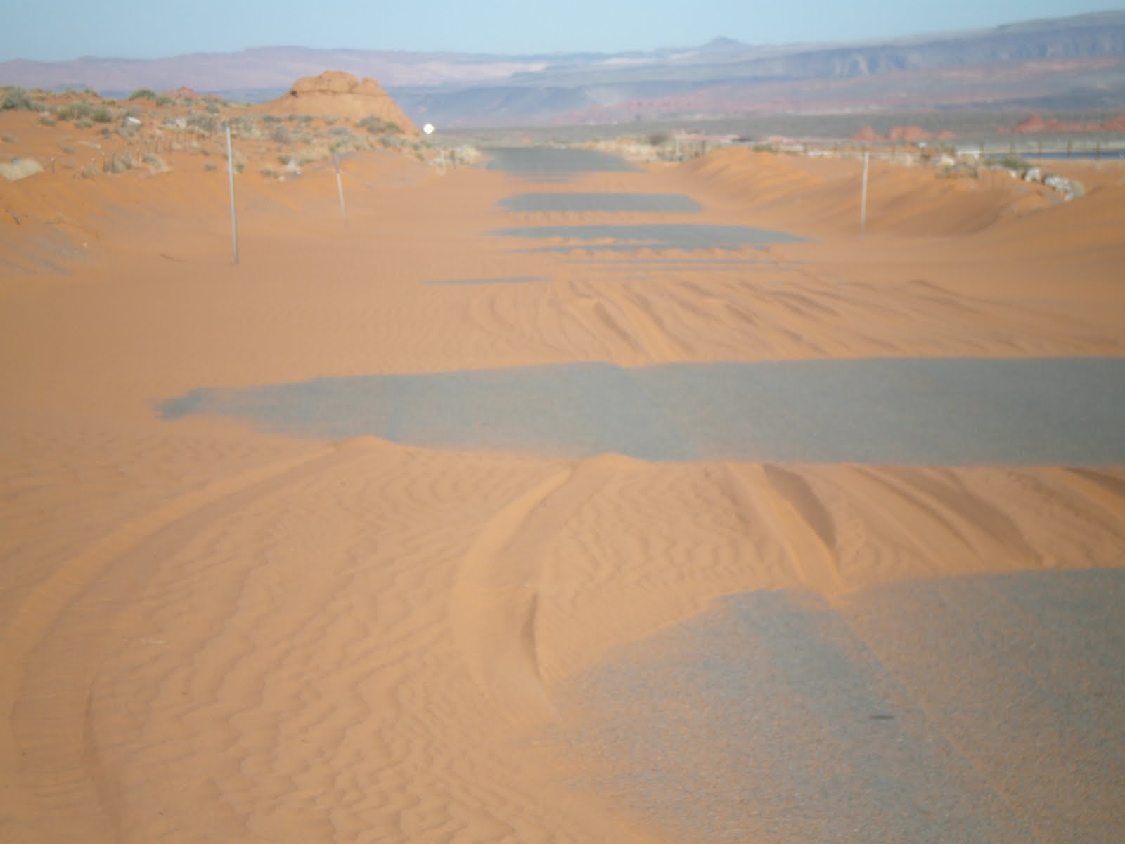


Above photo taken by my digital camera, shows the Sand Hollow Road near the south side of Sand Hollow State Park, and the continual sand which is covering the road. This must be hauled weekly to prevent a roadblock.
To access this road and area, to view Coriolis in action, take Hiway 9 from I-15 freeway, and turn right at the 2nd traffic, or Sand Hollow Road. This road makes a loop around Sand Hollow Lake, running into 3000 South Hurricane road, but stop at the “sand crossing” for photos and then proceed a kilometer further to the east- where there is a sand road to the right, with an unlocked access metal gate. This area is part of the SHSP, and also BLM lands, and is open to the public. There is deep sand on parts of the road toward the sand flow, and this road is made for ORVs. It is better to park just inside the gate (vehicles may NOT park outside the gate, since the SHSP prevents parking on the road shoulder. Proceed by foot to the west, going cross-country to the Jurassic Navajo sand dune crags to the SW. You will see great fractures running N60E, and they are obvious. Drainage traces N-S and the sand flow follows this trend to the north. Jurassic rock fossil dunes orient N-S also, since the wind in those 150 million year days was from the north. Occasionally the dunes will face the east, and this is the first anomaly which is connected with the Coriolis rotation observed. There are arduous treks in some of the deep canyons, and it is best to circle to the south to return in whatever canyon is best for your athletic ability.


Coriolis Force may be seen in action at Sand Mountain
Coriolis rotation (originally noticed by Gaspard Gustave Coriolis, in France) is exerted everywhere on the earth‘s surface. The normal presentation is with weather cells, where any movement of mass in the northern hemisphere causes a spin of moving air -to the right. You have to take the weatherman’s interpretation, where low moisture laden air moves toward a low pressure location, and in so doing rotates counter-clockwise (CCW) as the air always moves rightward of the direct path to the lowest pressure region. The reason for this is that the surface velocity of mass on its south side is greater than that on the north, related to space. This occurs due to the curvature of the earth, where there is zero velocity at the north pole and maximum (900 nautical miles/hour) at the Equator. When you shoot a rocket north-ward from the Equator, it has 900 mph eastward velocity before it is propelled, relative to space. After reaching 1N latitudinal degree, the velocity of the ground surface is about 890 mph (1/90th of the eastward velocity is diminished), but the eastward velocity of the rocket is still 900 mph; consequently, the rocket viewed from the ground surface appears to be going to the right (eastward, where the ground surface has not kept up with the rocket’s eastward component- regardless of the forward velocity of the rocket due to its propulsion).
Although this force and movement occurs everywhere on EARTH, EXCEPT EXACTLY AT THE EQUATOR, it is generally ignored, since it amounts to a small effect. However, for the earth’s crust, the movement is continual and is noticeable on a million year time scale- APPROXIMATELY 1 MM/YEAR. For example, below is shown a river meander, where the movement has a noticeable result (THIS HAS BEEN DATED VIA THE LOCAL VOLCANOES, AT LESS THAN 200 K.YEARS):


The time scale for the Virgin River meander is on the order of 200 k.years, since that is the date at which the last volcanic extrusion filled the old channel of the river. The river has since eroded through the laterally-fracturing basalt to etch a new path somewhat near the old one. Particularly interesting in the above photo is the junction of Gould’s Wash with the Virgin, since the first noticeable rotation occurs at the junction. This has been documented by me, finding slickensides on the canyon walls wherever there is lateral movement of the rotating Coriolis cells against the walls- which are moving at a different velocity. I have found these at the old Power House upstream of Gould’s wash, at vertical basalt beds along the Virgin path, and at locations where significant lateral shearing or scraping occurred.

AFTER YOU HAVE DIGESTED THIS, LOOK AT MY INTERPRETATION OF THE MOVEMENTS AND STRESSES WHICH CREATED THEM, ON THE FOLLOWING PHOTO. NOTICE THE INLET, TAKEN WHEN THE WATER LEVEL WAS HIGHER, OF A SLICE IN THE EARTH (REPRESENTING A FAULT OR MAJOR FRACTURE) ALIGNING WITH THE SPILL OF SAND HEADING NORTH TOWARD THE LAKE. THIS REPRESENTS A LINE OF SHEAR- LIKE THE WASATCH LINE- WHICH SEPARATES TWO ROTATING CELLS OR HILLS (SAND MOUNTAIN):

FINALLY, BELOW IS THE "BIG PICTURE" OF THE SAND MOUNTAIN, SHOWING THE CIRCULAR CONFIGURATIONS SURROUNDING THE UPLIFT. NOTE THE MULTI-ROTATIONS AND ARCUATE CLIFFS, PARTICULARLY THE INDENTATION ON THE SOUTH SIDE- WHICH IS A CANYON SHOWING CONVERGENCE OF TWO OPPOSITELY-ROTATING CELLS:

BELOW ARE SOME SCENES WHICH YOU WILL SEE WHILE HIKING FROM THE EAST, LEAVING YOUR AUTO AT THE METAL GATE AND PROCEEDING SW. THE FIRST PHOTO SHOWS THE WELL-DEFINED N60E FRACTURES, WHICH RESULT FROM THE TORQUE PLACED ON THE LINIATION BETWEEN THE TWO ROTATING CORIOLIS CELLS (THE SO-CALLED "WASATCH LINE":
 :
: THE NEXT FEATURE OF INTEREST IS AN EROSIONAL HOLE, FORMED BY A COMBINATION OF STRESSES: 1. THE LATERAL SLICING ALONG THE N-S DRAINAGE, AND N60E LINES OF SLIP, AND THE SPIRALING OF THE WATER FLOWING THROUGH THE WASH IN WET PERIODS. THE OBVIOUS THING IS THAT THE SAND WHICH SPILLS INTO THE HOLE DOES NOT FILL IT, BUT IS EJECTED FASTER THAN IT SETTLES. YOU CANNOT STAND IN THIS HOLE, SINCE IT IS MORE THAN 2 METERS DEPTH, AND IF YOU DROP INTO IT YOU WILL NOT BE ABLE TO CLIMB OUT- EVEN WITH A COMPANION GIVING YOU A HAND.
2. THIS DRAINAGE RUNNING N-S IS LOCATED AT THE BORDER OF TWO CORIOLIS ROTATING CELLS, WHICH RESULT FROM THE PROTRUSION OF EACH INTO THE SKY- RESULTING IN CORIOLIS FORCE CAUSING A RIGHT-WARD MOVEMENT FOR EACH (ONE IS RISING CCW, AND THE OTHER IS SINKING CW:

THE NEXT FEATURES OF INTEREST ARE 1. THE SPRING WHICH IS SEEPING ALONG AN OBVIOUS FRACTURE. FRACTURES OR FAULTING MUST BE OPEN OR ACTIVELY MOVING OR WATER CANNOT SEEP ALONG THE PLANE OF THE SLICE. I HAVE MEASURED THE TEMPERATURE OF SEEPS TO DETERMINE WHETHER THEY REPRESENT DEEP WATER OR THAT FROM RECENT PRECIPITATION, THIS ONE HAS NO DEEP CONNECTION- THE TEMPERATURE BEING 40F, THE AMBIENT LEVEL:

2. ANOTHER FEATURE, WHICH INDICATES UPLIFT FROM THE SOUTH IS THE TILT OF THE INTER-DUNAL PLANE (WHICH WAS LAID HORIZONTALLY, EVEN THOUGH DUNES ARE TILTED AND CROSS-BEDDED. THESE DUNES INDICATE THAT THE WIND IN THAT JURASSIC 150 M.YEAR AGE CAME FROM THE NORTH- WHICH OCCURS AT THE LATITUDE ZONE NEAR 20-30 NORTH AS OF TODAY (SUCH AS SAHARA DESERT AND SONORA. NE, ON THIS HIKE YOU WILL FIND THAT SOME DUNES FACE THE EAST OR NE, AND THIS INDICATES THAT YOU HAVE CROSSED A STRESS LINEAR, WHERE ROTATION HAS RE-ARRANGED THE ORIENTATION OF THE ORIGINAL DUNES:

VIEWING LOCAL DETAILS BELOW, WE FIND THAT THERE IS A TREMENDOUS AMOUNT OF INFORMATION SHOWN ON GOOGLE EARTH- WHERE WE MAY BE ABLE TO SOLVE THE GREATER QUESTION: WHY IS THE GRASS VALLEY CELL (WHICH CONTAINS SAND MOUNTAIN AND INVOLVES THE VIRGIN RIVER, AT ITS EDGE) GENERALLY ROTATING ABOUT THE GRASS VALLEY VOLCANO AND THE IVINS KNOLL- WHICH IS A BIT OLDER AS MEASURED BY RADIO-DATING?


No comments:
Post a Comment