

 OUR MAIN REGION OF HIKING, PHOTOGRAPHY, AND "LOVE OF THE EARTH" IS THE WESTERN USA, WITH THE 800 KM (IMPORTANT TO REMEMBER) COLORADO PLATEAU, CP, SHOWN BELOW:
I am going to take you for a tour of your surroundings- a useful WALKING and Photographing DESCRIPTION of the thin but wide portion of the North American continent, which I call the QUADRANSPHERE.

Why should you be interested in this? The Earth is your domicile, and you should want to understand the intricacies of it. You certainly will be impacted by such disruptive features as EARTHQUAKES and VOLCANOES.

ANOTHER VIEW OF SULLIVAN KNOLL IS SHOWN BELOW, FROM THE EAST:

And you will find that the entire globe is wiggling relative to itself, as well as hurtling through space. An example of movement is that at any junction of two streams, where it can be easily seen that the layers of the earth have been juxtaposed toward each other:


The EARTH is part of a gravitational system, where events and movements in any part affect the others. For example, when the ellipse created by the attraction of the larger planets for the earth pulls the globe toward the colder regions of the SOLAR SYSTEM an ice age develops. A fellow named Milankovitch discovered this relationship in the earthly 20th century and we will look at the scribing in the rocks which have resulted form these “wigglings”. (SEE FOOTNOTE 1, AT BLOG BASE, BELOW)
 BELOW IS AN ACTUAL PHOTO OF THE PATH OF THE SUN, AS IT TRACES AN ANALEMMA (GREEK, BUT YOU CAN REMEMBER THIS AS AN ANNUAL EARTH MAGISTRIA MANIFESTATION):
  Note that the ANALEMMA gives a measure of the sunlight directed toward both hemispheres; there is significantly less heating in the north, compared to the south. The analemma suggests that this is a driving force which continues to move heat and landmass toward the north. This hints that the dilemma of the Australian and surrounding islands moving northward and creating the Tonga Trench (which has the fastest shear rate- measured so far- of 26 cm/year) is continued by the dominant influence of the sun. Although being much further than the moon, the total eclipse shows that they are of equal importance- the Moon exactly covers the sun during a solar eclipse. Consequently, we now have a phenomenon of heating to add to the mix of factors determining the movements of the CRUST of the earth (in addition to the dominant feature of gravitational arrangement of features in the northern hemisphere).
Meanders of streams are a result of the wobbling of the earth. Monthly, the EARTH-MOON center of mass (some 1000 km below us, but not at the center of the earth) makes a “little dance” about this center, as shown by the gyration about the center of mass, by the combination of EARTH and MOON SPIRALING ABOUT EACH OTHER. This is accentuated by annual “gyrations of the hips” so that the water in creeks oscillates from one bank to the other. This shifting creates erosion on the inside of the concave surface, producing the meander.


ANOTHER FEATURE WHICH AFFECTS YOUR PHYSICAL ENVIRNMENT IS THAT OF COMETS, ASTEROIDS, AND THEIR IMPACT ON NEARBY PLANETS AND MOONS. BELOW ARE PHOTOS TAKEN OF THE PREDICTED STRIKE ON JUPITER, OR JULY 16, 1994, by earth Scientist SHOEMAKER AND WIFE, TO SHOW HOW THIS REMOTE STRIKE PRODUCED PERTURBATIONS ON JUPITER (AND LATER IN THE ENTIRE SOLAR SYSTEM- INCLUDING EARTH WITH LATER EARTHQUAKES, RESULTING FROM THE SMALL CHANGE OF ORBITAL CYCLING TIME AND DISRUPTION):

 GANYMEDE- ACCOMPANYING PHOTO- SHOWS A TRACK OF AN OLDER IMPACT, AND THIS IS SIMILAR TO SOME FOUND ON EARTH (IT IS A MOON OF JUPITER). IT MAKES A LINEAR TRACE, AND THIS ENTITY LATER PRODUCES AN ANTIPODE ON THE OPPOSITE OF THE SPHERE, WHERE VULCANISM RESULTS FROM PROTRUSION OF A SPLITTING DOME (SIMILAR TO ZION NP, WHERE CRATER HILL WAS ONE OF THE FIRST TO ERUPT AFTER THE ELTANIN SRIKE OF 2.15 M.Y. AGO). BELOW IS A PHOTO OF WOBBLES PRODUCED BY SUCH FEATURES AS ASTEROIDS AND "TUGS" FROM OTHER PLANETS:
ANOTHER RESULT OF ASTEROIDS, AND OTHER STRIKES ON THE EARTH IS THAT OF EXTINCTION OF SOME TYPES OF LIFE. THIS IS SHOWN AS "TROUGHS" ON A PLOT OF COUNTS OF FOSSIL GENERA VERSUS TIME, WHERE SOME SPECIES CANNOT ADAPT TO THE NEW ENVIRONMENT AFTER A SIGNIFICANT STRIKE- BECOMING EXTINCT (SEE FOOTNOTE 2, AT THE BOTTOM OF THE BLOG):

AS A RESULT OF MY OWN WORK AND ANALYSIS OF THE WESTERN USA, I HAVE FOUND THAT VULCANISM RESULTS FROM ASTEROID STRIKES (USUALLY ON THE OPPOSITE OF THE EARTH FROM THE STRIKE), WHEREAS ORBITAL CHANGES AND PERTURBATIONS CREATE ARCUATE SHEAR PATTERNS AND FRACTURES ON ROCKS- WHICH WE CAN VIEW:

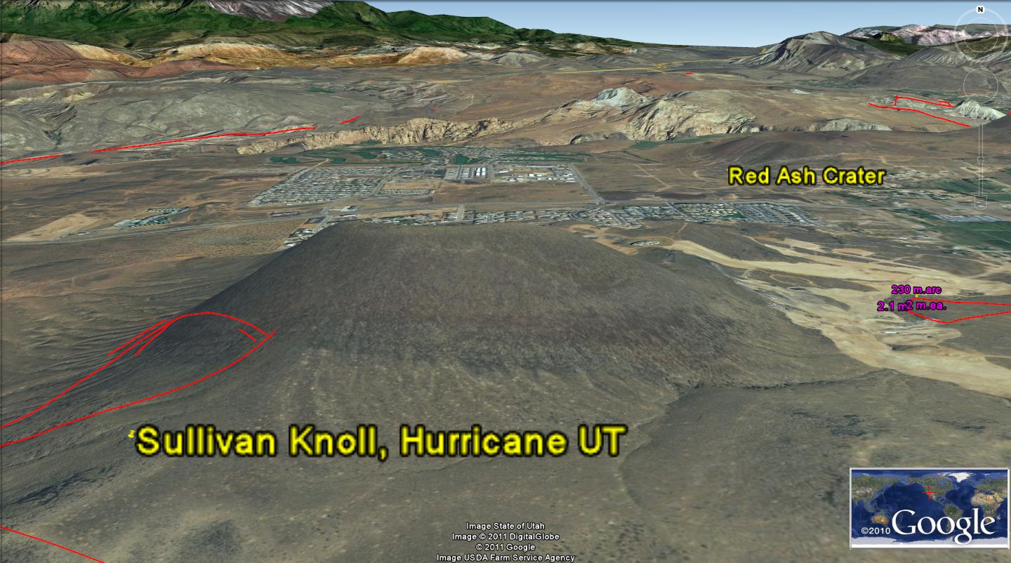
 DIGITAL PHOTOS, ABOVE AND BELOW, WERE TAKEN ON FIELD TRIPS OF AREAS NEAR HURRICANE, UTAH. THESE ARE DESCRIBED IN EARLIER BLOGS, AND DIRECTIONS ARE SOMETIMES GIVEN TO FACILITATE YOUR OWN FORAYS (SCROLL TO PREVIOUS BLOGS, SHOULD YOU WANT TO TAKE A PARTICULAR HIKE):
Journey, cont’d
The photo of the Beaver Dam outcrops introduces the TOPIC of CYCLICAL WOBBLES of the EARTH, which are produced by MILANKOVITCH-LIKE ORBITAL PERTURBATIONS. These occur due to interferences of the Moon, other planets, and the Sun with the gravitational positioning of the EARTH in the solar system. All bodies of rock and gas encircling the sun are arranged by distance and rotation rate by GRAVITY, as it “fixes” all mass with the equilibrium attained between outward sling (centrifugal force) of rotating masses and the inward pull (gravitational attraction) of the sun.

Large bodies distant from the earth impinge on this positioning to create small changes in the orbit of the earth, such as slowing by the Moon’s “friction”, or by creating elliptical orbits around the sun by large Planets. As a result, the earth gradually slows its spin rate (day length) and positions itself further from the sun with time. JSUN, or Jupiter, Saturn, Uranus, and Neptune are the principal “re-arranger” planets, while the moon-being smaller, but closer- is the most obvious body re-positioning our globe. These orbital changes create a steady force on the earth’s crust, and this causes a rotation which can be seen and measured in ROCKS. Below is a photo of a sandstone outcrop in Sand Mountain (near the Virgin River, on Sand Mountain at Hurricane, Utah), which shows this circular “scribing” of the rotation. This is a 40,000 year event, created by changes of the TILT of the GLOBE- marked by the TROPIC of Cancer at its 23.5N latitude location. This latitude is slowly changing as the planets “pull“ on the earth- causing it to wobble:

 THE WASHIINGTON CITY FAULT IS EASILY SEEN AS FRACTURES OR CRACKS CROSSING THE ROAD, ON THE NORTH SIDE OF I-15 FREEWAY, AND THE "BOILER" SPRING NEARBY IS WARM (77F)- ISSUING FROM AN OBVIOUS OPENING IN THE Jn RED CLIFFS THERE:
Geologists classifying features in the field would not miss this circular feature, but they probably would not know what created it. It is created by the 40k year rotation of part of the crust, as the tilt of the earth axis changes (with interference by the Moon and planets).
This display of beautiful circular arrangement has some practical value, since it represents a given time (40,000 years), and a rate of movement can be used to measure TIME. This is possible because there always occurs another shear feature at the edge of the outcrop- which is separated from the main rotation by a distance which is a constant fraction of the diameter of the circle seen above. This Ratio is 50:1 for the 40k cycles, 20:1 for the precessionary, and 100:1 for the elliptical cycles. This can be viewed by driving to the Green Springs Road in Washington, UT, or on Goggle earth as shown in the following photo:
 THE "GRID" IS SHOWN AT THE GREEN SPRINGS DRAINAGE (RAINFALL FINDS THE SHEARED SURFACE OF THE EARTH, AND IT PREFERENTIALLY ERODES CREEK BEDS OVER THE CRACKED AND FRACTURED EARTH). I FIND THAT THE SMALL GRID IS FORMED BY THE SMALLER (20K YR.) PRECESSIONAL CYCLE, WHICH IS SHORT-LIVED, SINCE THE EQUINOX CHANGES REGULARLY- NOTICE HOW SHORT THE DRAINAGE ALONG GREEN SPRINGS OCCURS.
The most western expression part of the Washington fault is shown along the road as a short N-S feature, lasting only a mile or so. It is produced by the wobble of the earth during the precession of the EQUINOX, as the earth‘s pole wobbles (producing the “curl“ at the top-North- of the spring-fed creek).
 THIS ACTIVELY-SHEARING LATERAL FAULT CREATES CRACKS CROSSING THE ROAD:
 TRY YOUR HAND IN FINDING AND INTERPRETING THE ARCUATE TRACES ON THE BELOW PHOTO. YOU MAY "ACE OUT" FIELD GEOLOGISTS- WHO WHEN CONFRONTED WITH THIS DISPLAY- THINK OF AT LEAST 5 DIFFERENT EXPLANATIONS, WHY THIS IS NOT AS SHOWN:
Let's take another TOPIC, which will demonstrate how the outer planets and the Moon create features which you see daily, and which you take for granted. There are several of these, near St. George and Hurricane, whch make beautiful scdenery, and which are young (relatively, GEOLOGICALLY)- that are associated with the same asteroid whch created the ICE AGE: this includes Sand Mountain, the Bend in the Virgin River, near the landfill, and Shnabkaib Hill, along the Washington Fault.
The “Hurricane” hurricane, and associated EYE of the HURRICANE

Digital photo shows a sink hole in Sand Mountain- which is in the bottom of a major drainage, flowing from the south- near the Virgin River, in the town of Hurricane. The Jurassic Navajo sandstone, with its multi-layers of dunes, was laid down in the Mesozoic time of about 150 million years age. This was during a time when there was a similar circumstance to that in the Sahara desert now. Latitudes of about 20N or 20S have winds returning to lower levels, completing the circular vertical pattern from the tropics by sinking. They sink because they are heavy- having been stripped of their moisture by raining in the latitudes near the Equator. As they sink, they heat, as in your tires, when you inflate them. The compression generates heat, and the combination of heat, high density, and sinking becomes high pressure air with clear skies, no rain, and desert-like conditions.
The sink hole occurs in this formation, which is entirely sandstone- mostly of dunes. Consequently it has a large fraction of pore space, or portion with only water or gas (air or other vapors). It easily erodes and brings sand everywhere. If you live near this feature, you will have fine sand continually blowing into your windows. This sinkhole has developed in such a sandstone.
Even though this sink is in the bottom of a wash- where seasonal rains flow- it remains clean and circular, with steep walls. It has not crumbled or filled. This is a testament to the fact that it is continually being kept circular, deep, and open. It is being kept distinct by circular stresses which allow it to drain downward, rather than through the young arroyo. The Google photo below shows that the entire mountain is rotating, developing a circular mountain, and this happens fast enough to offset erosion which tends to degrade all cliffs, scarps, and sinkholes:


I HAVE ADDED CIRCULAR ARCS, TO SHOW HOW THE VARIOUS MALINKOVITCH ROTATIONAL CYCLES HAVE LEFT THEIR IMPRINT ON THE COMPACTED SANDSTONE. THESE ARE AS OLD AS ONE MILLION YEARS, BUT THE ONES SHOWN ARE 40-100 K.YEARS. THESE ARE NOW REASONBABLY RECOGNIZED: ELLIPSES ARE OF THE 100 K ELLIPTICAL VARIETY, WHILE CIRCULAR ONES ARE EITHER 40 K OR EQUINOX 20-25 K.Y. PRECESSINAL- WHICH ARE RELATIVELY RARE (ALTHOUGH YOUNGER, THEY VARY RAPIDLY IN DIAMETER, BECAUSE OF INFLUENCES OF MANY BODIES IN SPACE).
FRUITS OF MY LABORS
I yearn for accolades galore,
Which never fail to fill the store
Of memories so bitter-sweet
That my legs can again remain UP-beat-
In the path of Nature, so displayed
That leaves POTATOES IN THE SHADE
From the couches they press down
Which leave their muscles with a frown
And allows me to funerals ATTEND
Where widows can their exercise amend;
If my torso ne'er relent,
I'll, by engineering, get EXTRA ten percent
Of smiles and giggles all around
While those more indulgent are sooner found
In ambient temperature 'neath the ground!
Harold L. Overton
Footnote 1: The farthest extent of the Sun to the south, near the WINTER SOLSTICE- was measured by referring to a flat-topped Mesa in Arizona, east of my dwelling during 1990-93. I was surprised that the shortest day of the year was not December 21, or even Christmas (which I thought was a cultural celebration of the beginning of increased sunlight). I measured this event by finding the exact time when the sun’s first gleam (before it ruined my iris) arrived on the mesa top. No allowance was made for refraction, air pressure, or temperature, since the dry desert air had low humidity of 10-20 percent. This emphasizes that there is a greater amount of heat from the sun on the southern hemisphere than occurs in the north. Although less continental landmass exists in the southern hemisphere, there is a hotter half-year in Australia as a result. Argentina is less affected, and Chile- being cooled by the adjacent cold currents, is dryer but relatively uninfluenced. The larger fraction of ocean waters absorbs the excess heat, which adds impetus to the circulation of South Pacific waters toward the north.

This entire phenomenon is determined by the ANALEMMA and the PEAR-SHAPED EARTH, developed from the incident of the separation of Australia from Antarctica; this is also co-incident with the PTr extinction of 256 m.y. age.

FOOTNOTE 2:
Instability of the CRUST, as seen by FOSSIL EXTINCTIONS
A GRAPH of regional rotation for the crust may be made from changes of orientation of ocean basin transforms, shown on
Google earth, as discontinuities of compass angles of adjacent transforms (for NV Miocene, Olympic Mountains, WA, Chixculub, Mexico, and Australian south coast).

CRUSTAL ROTATION, degrees= .35(5 x 16, Miocene, 4 x 32, EO, 3 x 64, KT, 2 x 128, Mid K, 1 x 256, PTr)=
Reverse series= 28, 44.8, 67.2, 89.6 degrees surging, regionally.
This is of the mathematical series: Rr (regional
Rotation)= Change/m.y. (n x age, n-1 x next older age, n-2 x earlier age, n-3 x age, n-4 x largest age). I have measured the change/million years for the Gulf of Mexico, and I will find a more appropriate and sharper presentation in some other
Tertiary location.

This series produces an approximation of the GRAPH, shown as transform orientation in “jerks”: 30 degrees, 45, 60, and 90 degrees SURGE. The 128 k.y. feature is missing, but repeats the 256 year of the GREAT EXTINCTION of the Permian-Triassic boundary. A plot of extinctions versus time indicates that this is mission on the fossil record, also.
THIS PUBLICATION WILL CONTINUE, WITH AUGMENTATION WEEKLY.
No comments:
Post a Comment