Wednesday, June 27, 2012

MIMA MOUNDS at the south of HOLMES HARBOR are older and larger than those at HOLMES GOLF- west of the WATERWAY and for PENN COVE

Near the SOUTH END of Holmes Harbor- a TROUGH of the Pleistocene GLACIER- THERE OCCUR  a series of MOUNDS, which occur in an ELLIPTICAL ARRANGEMENT that convinces me that they are TRUE MOUNDS of UPLIFT  CREATED by the STRESSES of ROTATION DURING INTERSTADES of the glacial RETREAT-ADVANCE. There should be 12 of these mounds (according to the MOON-SUN influence on EARTH EACH 12 months). There sometimes occur 12.5 of these, because of the RATIO of orbit times: 365.24/29 days for the two DOMINATING MASSES DETERMINING the gravitational re-arrangement of the EARTH'S CRUST:

WHAT CONCLUSIONS ARISE from the UPLIFT of MIMA MOUNDS at Freeland, WA- south of Holmes Harbor?

1.    The taller, wider MOUNDS, by the BINARY THEOREM, suggest that the mounds increase in size with TIME! This is not due as much from RISING of the ISOLATED MOUND, as to rise of the landscape; the higher landscape creates increased EROSION (and there are deep adjacent arroyos or gullies here); they are taller since the CRUST is eroding increasingly at the base)!


NOTICE the RATE CALCLATIONS (which should be between 10 and 20 mm/yr, from EARTH TIDES). These yield a check on the accuracy of my work! I am solving the EARTH TIDE MAGNITUDE at the same time that I am USING it! Consequently, I have to constantly check with some other method, to determine the CORRECT MAGNITUDE!


2.    Holmes Harbor is older than Penn Cove- which orients to the west and obviously occurs AFTER the older N-S movement of the Pleistocene glaciation. The 50 k.y. calculation indicates that the GLACIAL PROGRESSION-SHEAR LINES ORIENT N182 degrees (we must check to find the GLACIATION AGE of Freeland moraines). This finds that HOLMES HARBOR is aligned with the MIMA MOUNDS, and is associated with their creation, and that MOUNDS are a result of “CHATTER”- which is the 2nd derivative of acceleration- d(jerk)/dt, where JERK is the first derivative: d(acceleration)/dt- the EARTH’S CRUST temporarily encounters less LUNAR TIDAL SLOWING, creating BUCKLING or chatter in DIFFRACTION PATTERNS (see the classic arrangement at the TOP PHOTO- which was taken from the LITTLE ROCK MIMA MOUNDS STATE PARK);


Artificial EARTH WORK, or grading of roads and lots, creates a chance for error due to mis-interpretation of GOOGLE EARTH slicing, lateral movement, ARCS, and RISE-SINKING. Above photo shows the later history from the straightening of tree trunks, after SLUMPS have caused the trees to lean away from the RISES. I have digital photos I will insert to show the slumping which allows the TOP OF THE RISE to be identified.


A LARGER VIEW of MOUNDS to HOLMES HARBOR is shown above, to show the RELATIONSHIP of MOUND DEVELOPMENT to the SOUTH-TRENDING GLACIER MOVEMENT (CREATED in advance of the ICE, by TIDAL SHEAR ALONG N-S LINES). My finding is that the ICE followed the TROUGHS CREATED  by the GRAVITATIONAL FRAGMENTION created by the PERIODIC N-S SHEAR!


3.    The age of the CONTOURED ARC (to the south of Lot 14) is approximately 1/4th of that found to the west. Again, the BT has regular changes with x2 intervals, and MAJOR CHANGES with x4 multiples; the 4:1 ratio for the western feature indicates that the SPACE-TIME ROTATION is CW, with the mounds forming in a CW ORIENTATION with time (a DOMINATING ELLIPSE, formed by the MOON-SUN TIDAL OFFSET-COMPETITION); AND,

4.    Should these interpretations be correct, the CW ROTATION is against the trend of RISING CCW mounds, and must be incorporated in ANALYSIS. A similar occurrence is that of the CW ROTATION of BASALTIC EXTRUSIONS (east to west with time) around the Colorado Plateau, while the CP rotates CCW. This is created by the "RIP" induced by EXTENSION of the CP, as it RISES WITH TIME (visualize two waves enlarging with time, with the outer wave creating a GAP between the SPREADING WAVES- similar to a piece of cloth pulled apart at the LEADING EDGE.
These MOUNDS are formed with the COMPRESSIONAL FORCE CREATED by the SHRINKING EARTH as the ICE AGE ENDED- earth becoming closer to the sun. VIEW the SIMULTANEOUS RISE of Mt. Erie, as it aligns with Holmes Harbor along a N_S meridian (loxodrome):
 
ABOVE IS THE SMALL VIEW and below is the "BIG PICTURE" of the area near USELESS BAY, showing the GRAVITATIONALLY-FORMED ELLIPSE of 125 k.y.


Double Bluff is a set of cliffs to the SW of the Freeland-Fish mounds area. It should yield insight into the relation between the mounds, island dynamics, and GRAVITATIONAL SHOVE of landmass to the west and south. DB consists of two CCW rising cliffs, separated by a sinking CW small arcuate rotation (somewhat similar to 3 gears meshing- with the middle gear counter-rotating between the 2 larger outer GEARS). Though they protrude into the Admiralty Passage, and have GREATER storm erosion as a result, nevertheless they remain. This indicates that they move to the west faster than erosion can remove them. They are rising CCW, so that the older PEATS and Till may be viewed. Photo below shows the 3 arcs:
We can check the TIDAL MOVEMENTS RATE, by calcuating the AGE of regular arc features- by using the appropriate QUADRANT, and then measuring the separation of ARC CENTER LOCATIONS. Above is one such, first showing that the AGE is generally less than 1 m.y. for all features near the south end of the island. Above separation is near 30.72 mm/yr, with a 4.5% error. 
DOUBLE BLUFF is a result of earth waves- in this case about 5 km in extent, and at least 125,000 years in construction (geologocal age dating). this yields a time interval of 125km x 365.24 days/yr= 45.65 million days.  should the waves have a separation of 5 million mm= 5 km,the ratio of upward movement is near 10 mm/yr, as predicted by the binary theorem.


we will work with the calculated 4000 year cycle for deception pass island, to determine its ratio of occurrence, in relation to gravitational influence:
using the moon cycle of a half month,

4000 years x 365.24 days/year= 1.46096 million days, and comparing this to the half month= 14.5 days, the ratio is 100,000 to 1. therefore, the 4000 year land wave is equivalent to a half month water wave. this indicates a viscosity ratio, (10)exp 5, similarly, and you should wonder why this is not the (10) exponent 8 for water, found from the colorado plateau. this demonstrates the one-thousandth harmonic of the 41 m.y. feature, and i have previously found harmonics of 1/10th, 1/100th, and 1/10,000th.
 there occur other waves in the cliffs of whidbey island, which are generally smaller: 1000, 400, down to 320 years. hence there are smaller waves, which are due to smaller entities- such as small planets. these will induce land tidal waves of smaller length.


This region shows the VARIOUS FEATURES- such as SUN-MOON ANALEMMA (Sandy Hook), RISES, SINKS exhibiting 125k.y. PEATS, and a LINEAR DIVIDER (in white) which occurs near the previously-investigated LOWER MAXWELTON CREEK FAULT. This is an excellent area to attempt to correlate the various GRAVITATIONALLY-MOVED FEATURES, so that the SPACE-TIME RELATION rotating, vertically-moving, and shearing entities may be better undertood!
This is enlarged below:
NOTE the SHEAR ALONG the white line- TIDAL DIVIDER- which separates LUNAR fron SOLAR TIDES. This is smilar to the WASATCH LINE- which separates the RISING CP from the SINKING B&R, at a much more MAGNIFIED SCALE:


The larger ellipse- surrounding the top of the hill, just above LOT 14- has a DIAMETER of 1.28 km, yielding 125 k.y. AGE. This has occurred since an INTERSTADE- an ICE RETREAT- but  the retreat should not be construed as being the cause of ELLIPSE FORMATION. Rather, they both are formed by the GRAVITATIONAL CYCLE of the opposite of EXTINCTION (distinction- 2x intervals which are sandwiched between MAJOR 4x EVENTS)! The interval of 49.8 k.y. to 15.625 k.y. (43, 175 years) is the last ICE AGE ADVANCE EPISODE, according to the BINARY THEOREM. Local geological field work, dating PEAT BEDS, has established this age of the last INTERSTADE. It can be seen south of this ELLIPSE near the MAXWELTON BEACHES. Cycles of SINKING-UPLIFT can be viewed in the cliffs; currently, the PEATS are ROTATING CW- SINKING! I will hike to this area again, to see the CYCLES OF RISING-SINKING in the CLIFFS. Anyone interested in this 3 mile total HIKE, SEND MESSAGE to overtonharold@yahoo.com

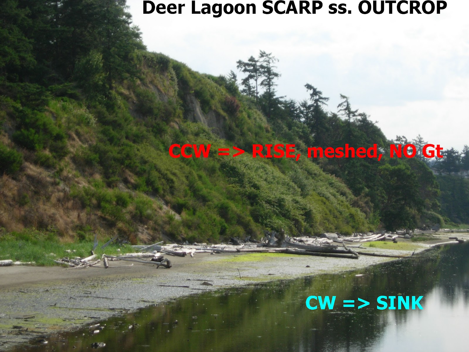
Double Bluff- Deer Lagoon is another ANALEMMA (RISE-SINK COUPLET) which bears on the exhibit of MIMA MOUNDS in the Freeland area. Notice that the largest AGE CALCULATED is 100 k.y.- the MILANKOVITCH CYCLE noticed since the beginning of the ICE AGE (2.048 m.y.?). Overall, Whidbey Island has been formed in that TIME INTERVAL, exept for the Deception Pass METASEDIMENTS. The white LINEAR is a demarcation-SEPARATION (WASATCH LINE) of CIRCULAR FEATURES- which have different TIDAL MOVEMENT RATES (SOLAR, 10.24 and LUNAR of 20.48mm/yr). These are pertinent except for SW QUADRANTS- which exhibit 30.72 mm/yr.


Hiking again this peat-strewn beach, the following CONCLUSIONS are reached:
1.    There is a PERIODICITY to the lateral measurement of the UPLIFTS-SINKS in a N-S DIRECTION (LAND WAVES): measurements (separations of CLIFFS’ MAXIMUM HEIGHT-EXPOSURE) are near 1920 (overall) to 330 (smaller waves) meters;

2.    Peats increase in thickness in the cliffs, and with MORE loose occurrence, to the south- where the SPALLING is most obvious (47 55'19.9N 122 26'34.4W);

3.    The ESPERANCE SANDSTONE (iron-stained sedimentary layers) rises generally to the south, interspersed with inflection-related seeps and rivulets. A photo of ESPERANCE (hope) is shown below:
Notice the ANALEMMA of SANDY HOOK at Possession point:

4.    Cliffs and tree-filled slumps (exhibiting seeps and water flow) alternate; and,
5.    There is a DISCONTINUITY in the cliffs (fault?) immediately preceding MAPLE POINT.

Digital photos show the MIMA MOUNDS, which my wife indicated were plain ol' KENTUCKY HILLS! Watch for these in your travels, where you are not biased in advance, to find the regularity (they are in ELLIPSES of 12+ mounds each!


Wednesday, June 20, 2012

CRUSTAL BLOCKS MOVING EASTWARD- Marianas Islands- illustrate that EARTH TIDES COMBINE LUNAR PLUS SOLAR in SW CORNERS of ORTHOGONAL FEATURES; e.g. the Basin and Range- 30.72mm yearly.


 I have previously solved the case of the B and R, where the younger valleys are 20 km in width. Further west, where the valleys are older, they are 30 km wide, illustrating that EARTH TIDES change from 20.48 to 30.72 mm/year in the intervening years. This occurs due to the movement of the Sierras to the west, while opening such features as Mammoth Hot lakes, as the Sierras-Central Valley rotates CCW VERTICALLY, causing the valleys to sink while the mountains rise (looking from the south). This opening allows geothermal features to develop (Monocraters and Mammoth Hot Springs), while shoving the new linear mountain ranges to the east (created on the east side of the SIERRAS each million years). Development of Expanding valleys occurs due to the expansion of ELLIPSES within the valleys- the width increasing with time due to an ellipse forming each 1 m.y. This occurrence happens in the SW CORNER of the B&R block. 
 This was solved for the case of the Marianas- where I served for two years in the USAF, at Anderson AFB, Guam. This is shown below, with a progression of photos showing that the Marianas-Guam is located in the SW corner of an orthogonal block (evidenced by the contact of N-S linears to the west and E-W linears to the east).


 The TIDAL MOVEMENT RATE must be checked independently! This can be done by determining the AGE of two separate features (on either side of Guam), and then finding the separation of the two features/years calculated by the DIFFERENCE of the AGES of the two ARCS. The age of both features requires that the divisor be known (which is the quantity to be solved). This requires that several rates be tested, and that the one confirming the feature to be solved is finally selected (TRIAL and ERROR)!


Now we can APPLY THIS FINDING to the BASIN & RANGE- which is a BLOCK of CRUST in the SW corner of the CP-B&R DUO analemma. The MOVEMENT there is SIMILAR to that of GUAM'S: EASTWARD in an ORTHOGONAL BLOCK, formed by addition of EARTH TIDES yielding 30.72mm/year (ULTIMATELY, from a 20.48 initially).

Below is one photo showing where a TRANSITION OCCURS: NEVADA'S AUSTIN SCARP (which divides the old WESTERN SINKS from the YOUNGER EASTERN VALLEYS-RANGES):


ABOVE INFORMATION is NOT VERY ACCURATE, but it is a start for FINDING  CRUSTAL ROTATIONS, which occur at least EACH 41 m.y.- as shown in the KIMMEI SEAMOUNT (exhibiting formation of the MENDOCINO TRANSFORM). This rotation has HARMONICS: 41 k.y. for the MILANKOVITCH AXIAL CYCLE, and others of smaller TIME PERIODS.


SUMMARY, EARTH TIDES from SUN and MOON:

 The earth has 4 quadrants, and EARTH TIDES VARY BETWEEN THEM. The TIDES result from a combination of LUNAR + SOLAR FRICTION, and they may OFFSET each other. Lunar friction occurs, dominantly, whenever the CONVEXITY of PRESSURE CELLS or CRUSTAL SHEARING CIRCLES point to the west (the case of NORTHERN HEMISPHERE America and Africa). SOLAR INFLUENCES can be seen (THERMAL and TIDAL) HAVING CONVEXITY to the east. This PATTERN of movement, WHICH IS APPLICABLE for CRUSTAL and OCEAN LOOP CURRENTS, indicates that the SE quadrant will exhibit 10 mm/year to the east, so that the net effect of all EARTH TIDES is 10 mm/yr. (20 west for NW, 10 EAST for NE, 30 east for SW, and 10 east for the SE- such as Florida- the average being (allowing only half of 30+10 in the SW and NE portions) 10 mm/year WEST- FOR THE LONG TERM). I am using the 2 digit numbers, but the BINARY THEOREM indicates that the more accurate RATES SHOULD BE 10.24, 20.48, and 30.72 mm/year!
NOTE that Florida is PRINCIPALLY MESOZOIC LIMESTONE, possessing KARST TOPOGRAPHY! This informs me that it has been subjected to DIFFRACTION PATTERNS CREATED by SOLAR TIDES OFFSETTING LUNAR TIDES. These create SINKHOLES, which are dynamic with the continuing GRAVITATIONAL DESTRUCTION of the CRUST (as DEEP as the CONTINENTAL SHELF SHEARED SURFACE).
There are DOUBTS about the SE CORNER, and these can be examined for Africa SE of the RIFT VALLEY. Florida is moving eastward, but the KEYS are creating an ARCHIPELAGO to the west. The influence of the MOON is directed toward the individual continents , and only a portion (15 days out of 365, for the irregular orbit compared to the sun's year) remains for formation of PROTRUSIONS (such as the ROCKY Mts. to the NW and South to the termination in Central America). This reveals that Mexico is older (post-4.096 b.y.) than Florida- which followed the 256 m.y. PTr uplift (SE from the Appalachian orogeny).

ABOVE IS THE SOUTHERN PART of AFRICA, BELOW the EQUATOR, and below is LAKE VICTORIA- which should exhibit reduced EARTH TIDES (10.24 MM/YR), because it is in the SE CORNER of the CRUSTAL BLOCK- which is AFRICA EAST of the RIFT ZONE:

NOTE THAT I HAD TO USE TRIAL AND ERROR TO FIND THE TIDAL RATE WHICH YIELDED THE MATCH TO THE AGE SOLVED BY CALCULATING THE RATE FROM EXPLORED MAGNITUDES of 10.72 to 30.72 mm/yr (km/m.y.).

There is DOUBT THAT the Lake- which borders the Equator- has CORIOLIS ROTATION- hence FORMATION of an ANALEMMA (they accompany each other, and are physically related) is NOT CONFIRMED! We have the beginning of the feature to the south, and the drainage MUST BE INSTITUTED there (otherwise this will NOT be the divider we seek). The literature reports that LAKE VICTORIA has developed since 800 k.y. AGE, and that it LAST started because of a DIKE BLOCKAGE to the north. My findings are that the lake has re-started many times, and that it is ANCIENT! At the equator, the BULGE rises and falls with the GRAVIATIONAL CYCLES, and I suspect that this occurs at least each 41 m.y. (with lesser harmonics- such as 41 k.y. MILANKOVITCH CYCLES).  I CANNOT SOLVE THIS TIDAL FEATURE YET, and will resort to analyzing others nearby: such as the SEYCHELLE ISLANDS- WHICH MAY BE OUTSIDE of the SE AFRICA CRUSTAL BLOCK:


NOTICE THAT the Seychelles are located in a NE CORNER of a separate location, so that we have interesting information, but it does NOT APPLY to SE BLOCKS- which is the locations of interest now!

Although the Seychelles are subject to the rotation of a block separate from AFRICA, the larger rotation involvng Madagaskar exhibits a SE CORNER, where the 10.24mm/yr movements occur! This represents NEW INFORMATION, and is outside of my analyses for Qsna. It will require significant anayses to determine why SEYCHELLES is not in the BLOCK, BUT THE LARGER BLOCK is PERTINENT! This may become clear with further analyses near the GREAT AFRICAN RIFT VALEY, where afterall, man (Lucy) developed into a RATIONAL ANIMAL- ABLE TO MAKE THESE ANALYSES!!


The case of MADAGASCAR-AFRICAN RIFT (offshore) illustrates that EARTH TIDES are gradually changing: from the OMNI-PRESENT SUN’s 10.24 mm/year to 30.72 when the NEW MOON adds its contribution. The FULL MOON creates maximum friction with the EARTH’S SURFACE for at most 4 days. After and beforehand, TIDAL FRICTION is reduced from westward to eastward- becoming maximum COMPRESSIVE at the new moon. The full moon and the sun pull the earth in opposite directions (CREATING EXTENSION) about one- sixth of the time, and this may account for the 13.6mm/year calculated for the RIFT-MADAGASCAR ROTATION of 60 to 216 m.y.

Compare EARTH TIDES with observable WATER TIDES; THE USUAL TIDE MOVES TO A MAXIMUM, remaining high for an hour or so. The in-coming and ebb contribute another 2 hours of high water. But this is a sinusoidal function, and it remains at a constant level (HIGH or LOW) for less than an hour! AFTER SUN’S TIDAL FRICTION, MOON’S is DOMINANT, but only for a portion of the time. Analysis of the Gulf of Mexico basin (a large feature, with maximum GOOGLE EARTH DETAIL) reveals that a quarter to a half of the rotation exhibits less than 20.48 mm/year TIDAL FRICTION. This represents at least a QUADRANT of the ELLIPTICALLY-SHAPED BASIN! This emphasizes that:

1.    AGE or time interval measurement requires that the SPECIFIC QUADRANT (of four) for any block of crust be known;

2.    The separate block must be determined from PARALLEL SHEAR LINES- which approximate a TRAPEZOID, with at least one side indeterminate (e.g. PARIA PLATEAU);

3.    The calculation of TIME INTERVAL= ARC DIAMETER/friction RATE, MUST be independently assessed, using either LOCAL GRID SEPARATION, or AXIAL CYCLE DIAMETER (e.g. COLORADO PLATEAU); and,

4.    The largest and widest CONTINUOUS ARC must be used for MAXIMUM TIME INTERVAL. There will occur other smaller arcs which are enclosed within the largest, and these represent subsequent EARTH WAVES. A good test is that they are concentric. There will ALWAYS OCCUR an opening or GAP or missing portion of a complete circle, and this may display another SERIES of ORTHOGONAL PARTIAL ARCS (e.g. analemma or figure 8 for another block of crust).

The above admonitions are made MORE COMPLICATED by the significant influence of VENUS’S GRAVITY (and of the other planets- according to their distance and mass: m/d). I am still solving these relations, but it appears that smaller masses in space result in SMALLER HARMONICS for smaller features (e.g. Sand Hollow and Mountain, UT- near the Hurricane fault, Hf). 


We will solve another case, connecteed with the OLYMPIC MOUNTAIN 45 degree ROTATION of post-eocene age. This has resulted in VANCOUVER ISLAND to Mt. Elias, AK being rotated from N to the NW. This one I can investigate this year in the field, since it is very near my summer digs. Take the ALASKAN FERRY and you can see closeup, without getting off the ferry, the TRANSFORMATION of MOUNDS to VERTICALLY-JUTTING METAMORPHIC MOUNTAINS! Relatively they rise- above the landscape as EROSION WEARS the base, TWIST CCW (with the RELATIVE RISE), and harden with the twist. When rock POROSITY is reduced to zero, METAMORPHISM BEGINS (regardless of the vertical location of the MOUND).


Mt. St. Elias has advancing GLACIERS, as opposed to MELTING ICE from GLOBAL WARMING! This appears to be due to the ALTITIDE INCREASE as the CRUST is shoved by LATERAL GRAVITATIONAL MOVEMENT (with the OBVIOUS INFLECTION at the turn from NW to west).

DIAGRAM below is a TRIAL BALLOON, FOR LATER IMPROVEMENT:

 These diagrams were drawn using the GEOLOGICAL METHOD: When there is little understanding, CATEGORIZE the information. I intend to go further- to determine the PHYSICAL MECHANISM, and then to MATHEMATIZE the PHENOMENA, or at least to present the data in a GRAPH. I have found that there are several MOVEMENTS, which can be discerned from GOOGLE EARTH VIEWS:
1.    DIFFRACTION PATTERNS form on the SURFACE of the EARTH’S CRUST- BOTH on LAND and UNDER the seawater- in the case of PUGET SOUND’S SALT WATER and adjoining WHIDBEY ISLAND;
2.    These WAVES have only shallow influence on the crust, and are similar to Rayleigh or other WAVES moving along the SURFACE of the earth;
3.    Diffraction occurs when a primary wave is impeded by an OBSTRUCTION, and two or more waves supersede the primary one- after passing the BARRIER (a mass transfer BARRIER for the case of ICE MELT being transferred to the sea for 15 k.y. GLACIERS). These waves interfere or cross each other, and REINFORCE (become stronger) with TIME. The process is such as to result in wider and deeper MOUNDS and DEPRESSIONS (KETTLES) as the process continues;


4.     WAVES OCCUR on MANY SCALES, and result in rises and inverse sinks; the larger scales produce SALT DOME RISES-KARST TOPOGRAPHY, and METAMORPHIC MOUNTAINS-DEEP TROUGHS, for the  larger and longer-in-time waves;
5.    These waves not only REPRESENT RESONANCES, but also occur in CYCLES- the most regular of which repeat at HARMONICS of the MOON CAPTURE, at 4.096 b.y., at 41 (40.96 or 1/100th) m.y.; and,
6.    Milankovitch’s 41 k.y. cycle of the POLAR AXIAL CYCLE (40.96?) is a tenth of a million (one hundred thousandth) resonance of the ORIGINAL LUNAR CRASH at 4,096 million years AGE.
Now proceed to the next DIAGRAM, which is a 3D view of the DYNAMICS of the SIERRA MOUNTAIN UPLIFT-CASCADE INITIATION:


Previously, I have developed a MODEL of "squeezing" of MASS at the base of the CRUST. This allows MOLTEN CRUST to be moved from just above the MANTLE to the SURFACE- thereby causing sag in other places, IN A CIRCULAR FASHION, CALLED a VOLCANO. This is a start to understanding the MORE GENERAL PHENOMENON of GRAVITATIONAL TRANSFER (LATERALLY), in CIRCULAR RINGS or "WAVES":
The next diagram hopes to understand the TRANSFER of MASS which occurs vertically at SINKHOLES ALONG MOGOLLON RIM, AZ. This process has created a SINK- CALLED METEOR CRATER- WHICH TRANSFERRED MASS over a time interval of 2.5 m.y. in JERKS. This is not a true meteor crater, but is similar to a PHREATIC EXPLOSION- where the CRUST was sheared at regular intervals and where the vertical PIPE WAS EMPTIED about 62.5 k.y. AGO (NOTICE the RATIO of 2.5m.y./62.5k.y.= 40- a critical number in the EARTH'S MOVEMENTS!


We may be able to increase UNDERSTANDING, by making a graph of the angular changes which the CRUST MAKES at CRITICAL SPACE-TIME intervals. This is plotted for several UNDERSTOOD FEATURES, that I have investigated in the field: Olympic Mountains POST-EOCENE turn of 45 degrees of VANCOUVER ISLAND, COSTA RICA 41 m.y. EVENT, and the ORTHOGONAL FEATURES at the COLORADO PLATEAU TRANSITION ZONE.


This will be investigted this summer, with FIELD TRIPS at the Olympic Mountains and Vancouver Island:
You see already how the CRUST MAKES VERTICAL ROTATIONS- SHOVING MASS down under the Pacific and lifting it at the BITTERROOTS! This represents at LEAST a 1280 km LATERAL MOVEMENT, for only a FRACTIONAL PART: 32km? VERTICAL RADIUS (NOTICE the 40 RATIO)!

TO BE CONTINUED: