Monday, March 19, 2012

Great Basin NP, NV, Miocene ANALEMMA Anomaly and ELLIPSE


SUMMARY:
WHEELER PEAK AND GREAT BASIN NP ARE OF 7 M.Y. AGE, AND ARE PART OF A LARGER ANOMALY AT 41 M.Y. (SPECULATED TO BE CAUSED BY AN INCREASE OF THE EQUINOXIAL CYCLE FROM 20.5 DEGREES, TO THE PRESENT 21.5 TO 24.5 TILT OF THE POLES).
EQUINOX SHIFT of 3 degrees (21.5 to 24.5?) is measured between the GAKKEL and LOMOMOTOV RIDGES for the TIME INTERVAL of 41 m.y.; SINCE GAKKEL SPREADING RIDGE has HEAT EMISSIONS, this is PROBABLY the AGE also. I have found this TIME INTERVAL in many locations: the ALEUTIANS, CENTRAL AMERICA, OLYMPIC MTS, WA, and now at the CRITICAL LOCATION- the NORTH POLE! THIS TILT IS EXPRESSED AS A TILT OF THE MOUNTAIN RANGES- UP TO THE WEST FOR B&R, AND DRAINAGES ARE TO THE EAST, AND WELL-DEVELOPED 1 M.Y. ALLUVIAL FANS. THE SOLAR TIDES ARE DOMINANT IN THE B&R, WHERE MOVEMENT OF NEW RANGES ARE TO THE EAST, IN A TOTAL OF 13 (EXTRUSIONS AT THE ID, UT, NV BORDERS: 12?), DETERMINED BY THE EARTH-MOON-SUN COMBO IN A 12-13 FULL MOON CYCLE, AUGMENTED BY JUPITER- WHICH HAS A 12 YEAR ORBIT AROUND THE SUN. MAJOR DRAINAGES OCCUR IN CANYONS, WHICH ARE ORIENTED BY SOLAR TIDES- WHERE A LINEAR (NOT A CURVILINEAR) "SPLITS" THE CRUST ALLOWING ATMOSPHERIC PRECIPITATION TO FIND THESE WEAKNESSES AND GRADUALLY DEVELOP MAJOR CANYONS. THESE ARE IDENTIFIED BY CONVEX TO THE NORTH ARCS ON THE NORTH SIDE OF CANYONS AND CONVEX TO THE SOUTH ON THE SOUTH SIDE- CREATING CANYONS WHICH FOLLOW THE SHEAR AT 10.24MM/YEAR. THESE "SPLITS" ARE YOUNGER THAN THE DRAINAGES, SINCE WATER FLOWS FROM ANY RISE, AND THE RISE MUST BE SIGNIFICANTLY HIGH IN ELEVATION FOR THE CANYONS TO WIDEN AND PRODUCE MORE SEDIMENTATION TO THE EAST. AN ANALEMMA IS FORMING, WITH THE MAJOR DIVISOR BEING ON THE WEST SIDE OF THE RANGE- WHERE A SMALLER ARC IS FOUND. THE RATIO OF DIAMETERS OF THE CCW/CW ROTATIONS IS 1.6- WHICH IS THE SAME AS THE ORBITS OF EARTH/VENUS. SMALLER ANALEMMAS ARE FOUND, AND THE LARGER MUST BE DETERMINED FIRST FOR AN APPROPRIATE ANALYSIS. THE LARGEST ANALEMMA IS SIGNIFIANTLY DIFFERENT FROM THOSE ON THE COLORADO PLATEAU, CP, SINCE THE TILT OF THE RANGE HAS PRODUCED A TRUNCATED CCW RISE AT WHEELER PEAK. THIS IS DUE TO THE SOLAR TIDES SHOVING THE WHOLE RANGE EASTWARD- ABANDONING THE OLD TRACE TO THE WEST, AS THE RANGE MOVES EASTWARD. NEW RANGES ARE PRODUCED EACH 1-2 M.Y., AND THE CYCLE IS NOW TERMINATTED WITH THE 12-13 RANGES PORTRAYED (END OF THE CYCLE OCCURS AT THE 13TH RANGE).


Google earth photo above shows how CANYONS ARE FORMED, when SOLAR TIDES OFFSET LUNAR TIDES. Two ARCS ARE CONVEX in opposing directions, which opens a LINEAR SLICE of the crust. This weakens the rock (with the shear along the advancing SLICE), and over TIME- HALF MILLION YEARS, IN THIS CASE- the atmospheric precipitation "finds" the weaknesses. These canyons are shown younger than the OUTWASH PLAIN to the east, and that is to be expected- since CANYONS OPEN NOTICEABLY as the sediments wash away (sedimentation follows the slightest rise, and canyons develop after a significant rise). This type of ACTION- OPENING of CANYONS in the CRUST- is RARE- DEVELOPING ONLY in the NE corners of BLOCKS of CRUSTAL-TRAPEZOIDS DEFINED by analemmas, where the RATIO of CCW/CW ARCUATE FEATURES (RISE/SINK) = 1.6, the same as the RATIO of orbit times for EARTH/VENUS. EXAMPLES easily seen on GOOGLE EARTH include GULF of MEXICO, the ALEUTIAN SPIRAL, and the CENTRAL AMERICAN CURLICUE.
INTERMEDIATE SUMMARY:
WESTWARD-MOVING EARTH TIDES are exhibited in The GREAT BASIN NP. It is youthful- less than 8 m.y. and lies within a larger 41 m.y. elliptical arrangement of the BASIN and Range Province. It exhibits actively-moving MILANKOVITCH CYCLES of 100 k.y. and younger arcuate-shearing features, easily measured on GOOGLE EARTH. ALLUVIAL FANS may be measured for AGE, and the drainages to the east may be seen to be augmented by small canyons created by opposing EARTH TIDES- allowing water to rise near the east edge of the rise. Advancement of the RANGE to the west may be measured by westward-moving ELLIPSES, moving at a separation of 40 meters per cycle, for 4000 year cycles (10 mm/Year).


The Great Basin is approximately 7 m.y. in AGE, and it is part of a larger feature- the 41 m.y. ELLIPSE within which it rotates. This is shown in the above GOOGLE EARTH view, where the CW rotation of the larger basin borders on the GREAT SALT LAKE. The Great Salt Lake, bordering the Wasatch Range shows that the Great Basin is rotating CW, since all sinks rotate similarly. Remember that RISES rotate CCW (the bordering CP), and they mesh with the adjoining SINK, CREATING ONLY MINOR HEAT and VULCANISM. The age of 41 m.y. is a major indicator of EARTH CHANGE, since this age occurs for the following:
1. The rise of the Sierras, in California;
2. The incipience of the Central American curlicue;
3. The initiation of vulcanism near Taos, NM, in the Llano Quemado- which proceeded to erupt to the west around the southern edge of CP;
4. The formation of an analemma in the Gulf of Mexico;
5. Rotation of the Great Plains, from the Mississippi River to the gap in the Rocky mountains, at the Arkansas River gorge; and,
6. Over-riding of the continent at the Olympic Mountains, WA- as evidenced by the Eocene rocks at the base of the anomaly.
A PREVIOUS BLOG THIS YEAR (SCROLL TO EARLIER SUBMISSIONS) HAS SPECULATED THAT THERE WAS A SIGNIFICANT CHANGE IN the TILT OF THE POLES AT THE 41 M.Y. AGE, BASED ON THE APPEARANCE OF THE KIMMEI SEA-MOUNT OF 41 M.Y (in the Hawaiian-Emperor seamount chain) RADIOACTIVITY-DATED AGE. NOW THIS NEW FINDING THAT THE GREAT BASIN STARTED ROTATING AT THE SAME AGE GIVES ADDITIONAL CREDENCE TO THIS SPECULATION.
LOOKING AT SMALLER DISTANCES AND TIMES, WE FIND THAT THE SOLAR TIDES ARE INVOLVED, SUCH AS TO CREATE CONVEX ARCS TO THE EAST. ALONG WITH THESE, THERE ARE STRAIGHT LINE LINEARS (NOT CURVILINEARS), WHICH OCCUR WITH INSTABILITIES OF GRAVITATIONAL WAVES. DATES CALCULATED AT OR NEAR THESE LINEARS ARE HIGHLY SUSCEPTIBLE TO LARGE ERRORS, AS WAS SHOWN FOR THOSE OCCURRING NEAR SULLIVAN KNOLL, UT, in an earlier submission.


I HAVE FOUND THAT A LINEAR (A STRAIGHT-LINE OR TROUGH) IN THE NE CORNER OF A TRAPEZOIDAL BLOCK OF EARTH CRUST, BORDERED BY CONVEX TO THE EAST (SOLAR) AND CONVEX TO THE WEST (LUNAR)- OPPOSITELY-OCCURING ARCS ABOUT THE LINEAR ESTABLISHES A MAJOR GRAVITATIONAL SPLIT. THIS "FIXES" AN UPLIFT, WITHIN WHICH THERE DEVELOPS A CANYON OR TROUGH. THE TROUGH WILL ALLOW HEAT, ANOMALOUS WATER, OR VULCANISM TO RISE. THIS IS THE CLASSIC CANYON FORMATION. NOTICE THAT THIS OCCURS SEVERAL TIMES IN THE GREAT BASIN:

NOTICE THAT THE SINKS IN THE VALLEY TO THE EAST ARE ONLY OF 1 M.Y DURATION. THIS TIME IS AN INTERVAL, NOT PERTINENT TO THE INITIATION OF THE GREAT BASIN UPLIFT- WHICH STARTED IN MIOCENE TIME. RADIO-DATING ESTABLISHES AN AGE PRIOR TO NOW. ARCUATE ROTATIONS OCCUR, AND ARE PRESERVED, FOR AN INDETERMINATE PERIOD- SINCE TIME OF DEVELOPMENT (THIS COULD BE THE AGE). IF THEY ARE IN PROGRESS, AGE WILL BE THE SAME AS THE TIME INTERVAL. SINCE MILANKOVITCH CYCLES MAY PERSIST (IN VIEW), THEY MAY NOT YET BE ERODED FROM THEIR INITIAL LOCATION. HENCE, ONLY WHEN TWO ARCS ARE ADJACENT, CAN WE BE SURE THAT THEY FOLLOW EACH OTHER, IN TIME SEQUENCE.
WHAT WE HAVE FOUND PERTAINS TO GRAVITATIONAL WAVES, WHICH ALLOW FEATURES IN NE CORNERS OF CRUSTAL BLOCKS TO EXHIBIT AN "INSTABILITY OF THE WAVES". I SPECULATE THAT THIS OCCURS IN 3 DIMENSIONS IN THE ATMOSPHERE AND IN SPACE, WHERE INSTABILITIES PREVENT PLANETS' LOCATIONS IN THE ASTEROID, KUIPER, AND OORT BELTS. IN SHORT, THIS RELATES A NEW ACTIVITY OF GRAVITATION- WHICH BEHAVES SIMILARLY TO LIGHT (VELOCITY, WAVE NATURE, AND FREQUENCY?)


GREAT BASIN has developed alluvial fans on the slopes to the west, and DRAINAGES to the east. These result from EARTH TIDES, where solar offsets lunar- convex to the west- and where a LINEAR SEPARATES the opposing movements to the east and opens the sediments for springs, seeps, and warm water. This allows shallow water for farms and "GOOD LIVING" along the edge of the basins. NOTICE the opposing ARCS along the drainage to the east.

ABOVE IS A FINAL ASSESSMENT OF THE LARGER REGION ABOUT THE GREAT BASIN NP, NV: THIS PHOTO SHOWS THAT THE ANALEMMAS IN THE B&R PROVINCE ARE MORE COMPLICATED THAN THOSE IN THE COLORADO PLATEAU, CP! SINCE THE MOUNTAIN RANGE IS TILTED UP TO THE WEST (OLDER FORMATIONS ARE EXPOSED ON THE WEST SIDE OF WHEELER PEAK), THERE ARE ALLUVIAL FANS ON THE EAST SIDE AND STARK SCARPS ON THE WEST. THE DRAINAGES THEREFORE FLOW TO THE EAST, SINCE THEY CANNOT CLIMB THE GRADE TO THE WEST. THE DATE OF 7 M.Y. IS CONFIRMED FOR THE OVERALL AGE OF THE RANGE, WHICH IS A PART OF A LARGER ANOMALY, STARTING AT 41 M.Y. (I SUSPECT THIS WAS INITIATED BY A SHIFT OF THE EQUINOXIAL CYCLE FROM 20.5 TO THE PRESENT 23.5 DEGREES- OF A CYCLE OF 21.5-24.5 DEGREES.) THIS IS PART OF A 13 M.Y. MOVEMENT, WHICH PRODUCES THE RHYOLITIC EXTRUSIONS AT THE IDAHO BORDER, AND THESE MOVE EAST-WARD BECAUSE OF THE DOMINANCE OF SOLAR TIDES IN THE B&R. THERE ARE LUNAR TIDES, AND THEY ARE ON THE WEST SIDE OF RANGES (WHICH ARE CONNVEX TO THE WEST); THEY DETERMINE THE SMALLER ARCS FOUND THERE, SO THAT THERE OCCUR MOVEMENTS TO THE WEST- SUCH AS THE SIERRAS PRODUCING THE MAMMOTH HOT SPRINGS ANOMALY. THIS IS FOLLOWED BY LINEAR-PRODUCING SOLAR TIDES EACH 1-2 M.Y. AND THIS IS THE DOMINANT ENTITY IN THE B&R.


GREAT BASIN RANGES move eastward with TIME since their incipience at MIOCENE 13 m.y. AGE:
ABOVE GOOGLE PHOTO divulges that the B&R has moved eastward, as it has created further east N-S ranges each million year period. This is followed by a west-developing arcuate range in the 2 million year entity; the succession is:
1. The Sierras move westward (41 m.y. uplift with the speculated EQUINOX TRANSITION from 20.5 degrees, arcuate CONVEX to the west), which opens the immediate valley to the east- such as MAMMOTH LAKE and HOT SPRINGS. This valley is then followed by a 1 m.y. RANGE to the east (RISE within a SINK);
2. THE FOLLOWING 13 (12?) m.y. TIME INTERVAL produces a series of N-S ranges, terminating at the TRANSITION ZONE, adjacent to CP;
3. Great basin is the 7th in the series of the 13 (or 12th?) proceeding towards the CP transition zone- which terminates the MIOCENE origination of ranges and valleys within the CW rotation around the entire B&R (including the 12-13 rhyolitic extrusions at the north border- SNAKE RIVER and Yellowstone blasts); and,
4. Each million year range is followed by a 2 m.y. rotation to the west (convex west)- developing an elliptical basin. These fit within an ANALEMMA which includes the large RISE and the somewhat smaller SINK (BASIN).
ALL OF THIS IS FASHIONED BY THE GRAVITATIONAL ADJUSTMENTS OF MOONS, PLANETS, AND SUN of the EARTH’s WOBBLES, with the exception of about 4% influence from HEAT from the SUN and radioactivity, magnetic-electrical variations, and extra-solar anomalies.
ABOVE PHOTO INDICATES THAT LAKE SEVIER (DRY) is the FOCAL POINT of a large rotation TANGENT to the GREAT BASIN; this is approximately 16 m.y. AGE, and hints that the destructive EVENT of FLOOD BASALTS IN WA AND OR was a continent-shaking AFFAIR:
GREAT BASIN NP, NV is located at the UT BORDER, and contains the 2nd largest peak in Nevada. It yields information about the formation of the B&R VALLEYS and RANGES. It also pertains to the SHIFT of the EQUINOX at the 41 (40.96?) INFLECTION, shown elsewhere at the KIMMEI SEAMOUNT, CENTRAL AMERICA CURLICUE, THE ALEUTIAN SPIRAL, and the MENDOCINO 40N TRANSFORM.
ABOVE PHOTO SHOWS THE LINEAR FEATURE JUST EAST OF THE WASATCH LINE, WHERE THERE IS A CIRCULAR ARRANGEMENT WHICH CONTAINS A LINEAR SPLITTING IT. THIS SIGNIFIES THAT THERE WAS A REVERSAL OF LUNAR VS. SOLAR TIDES, AS WELL AS AN ANOMALY IN THE EQUINOXIAL ANGLE (CURRENTLY 23.5, BUT EARLIER 21.5 DEGREES TILT). THIS IS ENLARGED TO VIEW THE WESTERN USA, SO AS TO DETERMINE THE RELATION OF G.B. TO THE FORMATION OF THE ROCKY MOUNTAINS, AND FINALLY TO THE CONTINENTAL SHELF:
ANALYSIS of the 41 m.y. EVENT, DISPLAYED in many OUTCROPS The first notice of the 41 m.y. was found in the Kimmei Seamount- a fulcrum of the rotation of the HI-Emperor Chain. The rotation of the chain at that point is not precise, and the 45 degree turn takes a few million years to make the transition of the chain to one of roughly NW-SE orientation. This slow transition seems to be typical of these earth movements- where the PTr, or Permian-Triassic transition, (which left most fossils absent in the Triassic) required a few million years to allow the Petrified remains of trees to become obvious. Later, it was noticed that the calculated 41 m.y. event was found in the Aleutian Spiral, the Central American curlicue, the rise of the Sierras, the initiation of basaltic extrusion in the llano Quemado (Taos, NM), and the start of over-ride of the Olympic Peninsula. The 40N latitude Mendocino TRANSFORM connects with the large rotation at the Kimmei seamount, and this slice has replicated itself many times- calculated to have occurred since 192 m.y. AGE. There are as many as 5 slices parallel- roughly- to each other. Previously, I have indicated that the 41 m.y event is related to the change of the angle of the EQUINOX, from a smaller magnitude to that near the present 23.5 degrees, by the relation: 41m.y./2 m.y. ELTANIN EVENT= 20.5- a harmonic of the EARTH’S “ ringing” mechanism, where 360 degrees refers to a circumference of approximately 40,000 km (333.33 km/3 degrees of latitude- less than 20.6% deviation, from the 420 km- measured at the GAKKEL-LOMONOTOV separation). There is still doubt as to the applicability of the number 41, compared to 40.96 m.y., as would be indicated by the BINARY THEOREM. The hundredth harmonic of the series: .02, .04, 08, .16, .32, .64, 1.28, 2.56, 5.12, 10.24, 20.48, and 40.96 indicates that this should be the magnitude of such cycles as the MILANKOVITCH AXIAL ROTATION (k.y.), and the age of the MOON, in b.y. since the measured radioactivity AGES of such events as KT (65 m.y.) and PTr (251) have a less than 4% variation from the BINARY THEOREM (64 and 256 m.y.). I take this to be departures due to non-gravitational influences. These could be due to magnetic-electrical, thermal, or extra-SOLAR event, and I have made NO DETERMINATION of the one which is pertinent to GRAVITY ALONE. WE CAN EXPLORE the pertinence of both by use of RATIOS, such as the EARTH/VENUS ORBITAL CYCLES (days/year)= 1.62, from calculation, and from ccw features/cw rotations of crust- such as ANALEMMAS shown by the Aleutian Spiral, DAILY WEATHER LOW/HIGH PRESSURE CELLS, or by measured diameters of CP/B&R ARCUATE FEATURES in the EARTH’S CRUST. I have measured both 1.6 and 1.62, so that the evidence presents a MIXED BAG. CALCULATIONS YIELD: 40 k.y. AXIAL WOBBLE/25 k.y. PRECESSIONAL= 1.6, but the Precessional angle varies over a cycle from 21.5 to 24.5 degrees (literature reported), so that 40/21.5= 1.86, to 40/24.5= 1.63. The present calculation is: 40/23.5= 1.70- which yields NO CONCLUSION! ALTERNATIVELY, 40.96/21.5= 1.9; 40.96/24.5= 1.67, and these are close to: 41/21.5= 1.907; 41/24.5= 1.673. it appears that the RATIO 1.63, for 40,000/25.5 k.y. is closest to the 1.6 ratio I get from GOOGLE EARTH, so that I will continue to amass data which is measured, and NOT CALCULATED! Below is that for the COLORADO PLATEAU/BASIN and RANGE:
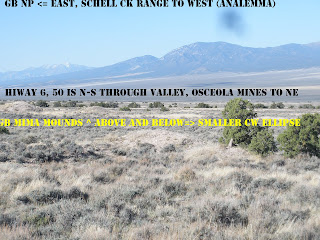
Digital photos, taken on an expedition May 4,5 2012 are shown below. I had 2 objectives: 1. Find a PC outcrop of AGE 1.024 B.Y. OR MORE, to determine whether there are more that have "escaped" the great UNCONFORMITY (SCALPING) found in the GRAND CANYON in a GRABEN. I hope to shed more light on the "EJECTION" of half b.y. or at least 96 km of missing stratigraphic column (except for elliptical waves found from AZ to Canada), and 2. Determine whether the Snake Range has expanded, starting in the POST-mesozoic, at about the 41 m.y. AGE: %2BMIMA.jpg" imageanchor="1" style="clear:left; float:left;margin-right:1em; margin-bottom:1em">
GOLD was found to the west of present GB NP, in the Osceola area to the NW. This area has a good gravel road, where MIMA MOUND and analemma ANOMALIES may be seen:
An ALLUVIAL FAN is unusual, being older than a 100 k.y. cycle, enough to have allowed junipers to proliferate (notice the ones to the south are scant, as is the SEPARATION of the Drainages- which are wider and older to the NORTH:
SCHELL CREEK has beeen documented via an erxcellent LANDSAAT 5 SATELLITE PHOTO (availlable at the NPS visitor centers), and it shows EARTH TIDE INFORMATION and ARCS clearly for calculations- better than GOOGLE EARTH. LOOK for both LINEARS and curvilinears, which allow calculation of INTERVAL TIMES for development of analemmas, trapezoids, and MILAQNKOVITCH CYCLES:
SCHELL RANGE IS THE NEXT TO THE WEST, TRENDING N-S, AND EXPECTED TO MIRROR the SNAKE RANGE. Upon expanding or exhibiting EXTENSION, TWO RANGES SHOULD PULL APART WITH TIME, AT A RATE of 20.48 mm/yr, if both are arcuate to the WEST, or 10.24, if opposing arcs occur.
AUSTIN, NV has a SCARP which divides the BASIN and RANGE into the western part- an older 7-13 m.y. greatly eroded region, and the EASTERN PART, INCLUDING GREAT BASIN NP- which is less than 8 m.y. AGE. This is regular, due to expansion or EXTENSION to the east. Simultaneous with this, 13 violent RHYOLITIC EXTRUSIONS OCCURRED (until present 3 ATTEMPT Yellowstone calderas). NOT TO WORRY, the trend cannot push east of the ROCKIES, since earth tides cause the ROCKIES TO PUSH TO THE WEST!
VARIOUS VIEWS of the DIVIDING SCARP are shown below:
The anomalies and SCARP have provided a rich MINERAL DISTRICT!

Saturday, March 17, 2012

DISCONTINUITIES, or INSTABILITIES in GRAVITATIONAL WAVES:

Summary: gravity is expected to travel at the speed of light- 3 x 10exp.10 cm/second, or 10exp5 km/second. What is not known is the discontinuous nature of the gravitation waves, in positioning mass as planets, asteroids and comets. The asteroids represent “forbidden zones” where planets are unstable- as with the asteroid belt between Mars and Jupiter, the Kuiper belt outside of Pluto, and the irregular comet origination distances. Gravity appears to prevent normal TIDES, in the positioning of mass at 1/4 to 1/8th of locations I have noticed on earth (NE corners of BLOCKS of CRUST) SUCH as the NE corner of the Gulf of Mexico, and in the NE corner of a block containing Sand Mountain near the Hurricane fault.
GOOGLE EARTH has revealed that there are periodic drastic changes in the orthogonal arrangement of breaks in the history of the EARTH: 256, 64, 16, 4 m.y. and there is now a hint that there was another at 1 m.y. This is also predicted in the BINARY THEOREM, where there are regularities in the fossil extinctions (2, 4, 8, 16 flood basalts, 32 Oregon plant changes, 64 KT dinosaur die-off, 128, and 256 m.y. PTr Permian-Triassic extinctions).
There seems to be another gravitational regularity of breaks in the positioning of objects about the SUN. P is planet, B is a break:
OBJECT DISTANCE, km, DISTANCE AU, RATIO to Mercury
Mercury 1 unit, .58 x 10exp.6 .387, to earth 1.0 P
ASTEROIDS 414.6 x 10exp.6 2.764 B 7.142, basic ratio
PLUTOIDS 5.9 x 10 exp.6 B 39.3AU 101.7, 14.24 (2 x asteroids)
KUIPER BELT 39 to1000AU, 102 to 2584 x Mercury (14.2to 935)
This is a multiple of 65.8, about the same as the KT multiple (64).

OORT CLOUD: up to 10 exp.5 AU, or 150 x 10exp.11 km (258,400 ratio to Mercury). This is near 1000 x 256- the PTr extinction in m.y. Again, we are equating time and distance, which Milankovitch has found correlates with the wobble and elliptical anomalies of the Pole positions.
The regularity is shown by the RATIOS: 2 (asteroid belt), 4 (Plutoids), 16 (inner Kuiper?), 64 (Kuiper), 256 (Oort cloud x 1000).
All this reveals that there are “forbidden zones” in the arrangement by GRAVITY of mass locations. Extrapolating, this would explain the zones between Lunar and Solar tides, where there is unusual error in using either 10.24 solar, or 20.48 mm lunar TIDAL MOVEMENTS. I measured 1 mm/year, for the Whidbey Island Penn Cove, where there was an inexplicable westward turn in the movement of the last glaciations (from southward to 256 degrees from north). This was accompanied by a reduction of tidal movement to 1 mm/year, and occurred with the last surge of ICE at approximately 14,000 years prior to now. I explained this anomaly as due to the transfer of mass (ice) to the seawater, causing the pole to develop a wobble with the weight of the ice moving away from the mountains to the sea.
IT APPEARS THAT GOOGLE EARTH IS TELLING US THAT GRAVITATIONAL ANOMALIES OCCUR ON THE 2-DIMENSIONAL MAP AS WELL AS IN 3-DIMENSIONAL SPACE. THE SUN ARRANGES MASS ACCCORDING TO THE BINARY THEOREM!

PROMOTION OF JUPITER:
The requirements for classification of a STAR are as follows:
1. The mass should be sufficient to promote FUSION, requiring Hydrogen and Helium be the main components. A BROWN DWARF is a star not meeting the mass necessary for heat generation by fusion, and this could be the case for Jupiter;
2. The size of the star determines the compression of the mass for fusion and this can be smaller than our SUN, with its 1.5 million km diameter (1 % of the distance from the EARTH);
3. Jupiter has more heat generated than is transmitted from the sun(a NET OUTFLOW), and this is thought to be due to compression, but could easily be due to nuclear processes. Due to the density being larger than that of the sun, this indicates that the core is not HYDROGEN and Helium but metallic. This may be an error, in which case Jupiter could be generating heat by processes unknown. This allows the planet to be a dwarf star, and this could be the case for re-consideration; and,
4. I have found that there is an instability at the ASTEROID BELT (between Mars and Jupiter), and this indicates that Jupiter is in the initiation of a new category of GRAVITATIONAL WAVES.
Altogether, Jupiter may be a CANDIDATE for DWARF STAR category- one which generates insufficient heat (FISSION OR RADIOACTIVE DECAY- PARTICULARLY K40?) for the case of FUSION, but sufficient for it to become a TRANSITORY STAR. THIS would be that of a BINARY twin to the SUN.
Although the mass of Jupiter is only 1/10 % of the parent SUN, this does not eliminate it from consideration as a dwarf star. It has some 60+ moons, is composed mostly of hydrogen and helium, and is generally considered as a mini-solar system. Let’s promote it to a BINARY DWARF STAR, SINCE THE BINARY THEOREM WORKS EXCELLENTLY (WITHIN 96% OR 4 PERCENT ERROR)!

GRAVITATIONAL INFLUENCE appears dominant in the creation of displacements, shear, rotation, and CRUSTAL EARTHQUAKES on earth. Possibly a tabulation of the measurements of planets’ mass, distance from the sun, and RATIOS of these magnitudes will yield insight about the relative importance of the planets. Further, there is the finding that the asteroids represent discontinuities in gravitational waves- such that planets in the asteroid, Kuiper, and Oort belts cannot survive (and only fragments, such as comets and asteroids- remain). We will look for hints that the RATIOS of distances of the planets will denote the importance of categories of planets:

ORDER of PLANET DISTANCE from SUN and RELATIVE RATIOS
Mercury Venus Earth Mars Jupiter Saturn Uranus Neptune, M km
57.9= 1: 108.2 150 227.9 778.4 1,426.7 2,871 4,498.3 M km
1.0 ref. 1.86Hg 2.59 3.936 13.44 24.641 49.59 77.69 to Mercury
.386earth .721 Earth=1 1.52 5.19e. 9.51e. 19.14e. 29.99 disc.@Jup.
.254Mars .475M .658 1.0 ref. 3.42 6.26 12.60M 19.74 Mars 3.94
.074Jup. .139 J .193J. .2937 Jup.=1 1.833 3.688 5.779
INVERSE 7.19 5.18 3.405 1.0 .546 .271J (preces?) .173 (5.78)
Sat. INV: 24.6 13.2 9.5 6.26 1.833 1.0ref. .4969 (2) .317 (3.15)
Ur.INV: 49.59 19.14 12.6 3.688 2.012,binary1.0 .6382 (1.59,anal.)Nept.INV: 77.7 41.57 19.74 5.7789 3.153 1.567 1.0 ref.

RATIOS most prevalent in CRUSTAL ROCK SHEAR occur more often with Mercury and Uranus. There is a hint that Jupiter represents a discontinuity, but this is not confirmed by Uranus- which has more familiar RATIOS than other planets in the ROCKY category. Earth/Mars ratio of 2.59 is the closest to the 2.5=100/40k.y. of Milankovitch cycles, whereas Venus/EARTH RATIO of 1/.721= 1.387 is closest to the expected ratio of earth radius/barycenter (center of mass from earth center, of EARTH-MOON COMBINATION) of 1.4. Although Jupiter has more mass than all the other planets combined, and is expected to represent the initiation of a 2nd gravitational wave from the sun, it does not divulge any RATIO which makes it pertinent to shear or rotation in crustal rocks. CONCLUSIONS:
1. MERCURY is of greater influence than others, as shown in the above table. I had expected that its influence is minimum, since it is the smallest, has little wobble, and represents the beginning of the first gravitational wave from the sun. It even displays the ratio Uranus/Mercury= 50- which is the EARTH CIRCUMFERENCE/distance between major TRANSFORMS in the Pacific (7.2 degrees of longitude, or 800 km- 1/50th of 360 degrees or 40K km for the entire earth);
2. URANUS is at the termination of a GRAVITATIONAL WAVE (beginning of the PLUTOIDS, or Kuiper belt planetoids; NEPTUNE?), whereas Mercury is at the start of the 1st wave. Middle ground exists at Jupiter, but the LARGEST PLANET represents more of a disruption than anything else. I expect that Jupiter occurs at the opposite portion of a gravitational wave- at an inflection (a downturn, if Mercury and Uranus represent initiation of waves); and,
3. Mars exhibits the ratio of 3.94- the ratio of Milankovitch’s ELLIPTICAL/PRECESSIONAL cycles= 100/25= 4.0. It is an intermediate, and the last of the rocky planets. It should have maximum wobble of the poles, and influence earth considerably, since it is closest. Although it is smaller than earth, it is almost as bright as Venus- the one influencing our weather the most.
ASTEROID CERES is likely at a LIGHT WAVE INFLECTION Although Jupiter is the beginning of an anomalous location of a GRAVITATIONAL CHANGE, the most likely inflection would occur within the ASTEROID BELT. CERES is the largest of the candidates, and it exists 2.767 AU, or 500 seconds/AU, at 1385.5 seconds from the sun. This is equivalent to 1385/60 minutes/1440 minutes/day= .01604 days (1/60th day). Pluto at 5906.38 million km, or 19,688 sec. (.2279 days), may be a candidate for the inflection occurring at the Kuiper Belt. The ratio of these 2 inflection distances is 14.23. This calculates 6.24x10exp-4 years for the Kuiper belt, and 4.392x 10exp-5 years, for the asteroids.
The anomalous 41 m.y. feature occurring many places on EARTH is equivalent to 1293.83x10exp+6 seconds, which is 3.88x10exp+9 km. The circumference of EARTH is 4x10exp+4 km. or approximately 1/100,000th (10exp-5) of the distance LIGHT TRAVELS in 41 m.y. (3% error). This is a resonance, and further related to the inflections at .107 for Ceres (415.05 million km/3880), and 1.52 for Kuiper (Pluto at 5906 million km). The expected error of 4% or less applies to Kuiper (1.5), with an error of 7% for Ceres (1/10th HARMONIC). The 41 m.y. anomaly can be related to the resonance of gravitational waves at the asteroid and Kuiper inflections or “FORBIDDEN ZONES”.
LET'S ANALYZE AVAILABLE MEASUREMENTS for the VARIOUS AGE EVENTS

EVENT AGE POSITION LOCATION ARC-ENCLOSED FULCRUM, BEYOND EVENT:
PTr 256 m.y. SW coast, Australia Spratly I. 5000km/N (2x KT)
KT 64 M.Y. Yucatan Mexico Cayman SE900km, Curacao 2600km
Flood basalt 16 OR WA USA Olympic R.-Siskiyou 590km/60 (1/4)
Hudson Byam 4 Canada NW passage 1856km/347, NNW (1/1.4)
Chesapeake 8 USA Cape Hatteras 362 km/N (1/8th)
Puget Sound 15,625 USA Olympic Mt. 98km/E E. side of SOUND

RATIOS of FRAGMENTATION separation are in the 2x ORDER, except for NW passage, and 1/26.5 (near 1/24th) for Puget sound, or the ELLIPSE formed at Byam Martin Island. This requires an investigation into the excessive elliptical extension to the north. This is the method used with gravitation, to form the ELLIPSE ENCLOSING an ANALEMMA. THIS EXPLAINS THE SHAPE, but NOT the FRAGMENTATION! It appears that WAVES have destructive power, in both SPACE and at ORTHOGONAL (CARDINAL POINTS of the COMPASS) extremities on continents. Notice that the FRAGMENTATION OCCURS at borders of land mass (coastlines), and that the SEPARATION DECREASES with time- since the AGE of the EVENTS. The important question to ask: “1. Why does the severity decrease with time, and 2. why does it occur at extremities?”
The answer to 1. the edge-of-continent query, should be: GRAVITY WAVES fashion most obviously at the contrast of LOW DENSITY SEAWATER and HIGH DENSITY ROCK (note that basalt contrasts more than continental crust, with water, and that OCEANIC VOLCANOES fragment more rapidly than coasts: witness MAUI, of 2 m.y- compared to SAN FRANCISCO PEAKS, AZ, which are just beginning to fragment.
2. The distance of EARTH from SUN increases with TIME (EARTH ORBIT SLOWS, and the ellipse ELONGATES). It has been reported that the 100 k.y. MILANKOVITCH CYCLE has become noticeable in ICE AGE CORING, (NOT BEFORE, with 40k.y. cycles dominating in older samples, less for those occurring after 2 m.y.) and there occur million year and 2 m.y. ellipses in rock outcrops. There may be Critical DISTANCES, above which gravitational destruction becomes of lesser importance!

CARDINAL POINTS SEPARATION from CENTER of FRAGMENTATION: The progression of GRAVITATIONAL DISTURBANCES, or EXTINCTIONS, according to the BINARY THEOREM: EVENT AGE POSITION LOCATION FULCRUM BEYOND PTr 256 m.y. SW coast, Australia Spratly I. 5000km/N (2x KT) KT 64 M.Y. Yucatan Mexico Cayman SE900km, Curacao 2600km Flood basalt 16 OR WA USA Olympic R.-Siskiyou 590km/60 (1/4) Hudson Byam 4 Canada NW passage 1856km/347, NNW (1/1.4) Chesapeake 8 USA Cape Hatteras 362 km/N (1/8th) Puget Sound 15,625 USA Olympic Mt. 98km/E E. side of SOUND RATIOS of FRAGMENTATION separation are in the 2x ORDER, except for NW passage, and 1/26.5 (near 1/24th) for Puget sound, or the ELLIPSE formed at Byam Martin Island. This requires an investigation into the excessive elliptical extension to the north. This is the method used with gravitation, to form the ELLIPSE ENCLOSING an ANALEMMA. THIS EXPLAINS THE SHAPE, but NOT the FRAGMENTATION! It appears that WAVES have destructive power, in both SPACE and at ORTHOGONAL (CARDINAL POINTS of the COMPASS) extremities on continents. Notice that the FRAGMENTATION OCCURS at borders of land mass (coastlines), and that the SEPARATION DECREASES with time- since the AGE of the EVENTS. The important question to ask: “1. Why does the severity decrease with time, and 2. why does it occur at extremities?” The answer to 1. the edge-of-continent query, should be: GRAVITY WAVES fashion most obviously at the contrast of LOW DENSITY SEAWATER and HIGH DENSITY ROCK (note that basalt contrasts more than continental crust, with water, and that OCEANIC VOLCANOES fragment more rapidly than coasts: witness MAUI, of 2 m.y- compared to SAN FRANCISCO PEAKS, AZ, which are just beginning to fragment. 2. The distance of EARTH from SUN increases with TIME (EARTH ORBIT SLOWS, and the ellipse ELONGATES). It has been reported that the 100 k.y. MILANKOVITCH CYCLE has become noticeable in ICE AGE CORING, (less than 2 m.y.) and there occur million year and 2 m.y. ellipses in rock outcrops. There may be Critical DISTANCES, above which gravitational destruction becomes of lesser importance! FRAGMENTATION due to GRAVITATIONAL FORBIDDEN ZONES not only occurs in the ASTEROID BELT, but in EARTH’S CRUST ARCHIPELAGOS such as E. and WEST INDIES: The BINARY THEOREM finds that extinctions (and distinctions) occur in a pattern, due to occurrences of DISRUPTIONS caused by regular anomalies at the CARDINAL POINTS in Qsna- the North American QUADRANSPHERE, an ELLIPSE where fragmentations occurred at the east, south, west, and an extended north extremity. This includes the antipode to the PTr EVENT, the KT at Yucatan, the FLOOD BASALT near the Columbia River, and the NW passage at Byam Martin island. The CW rotation of events has continued, to embrace the fragmented Puget Sound, and the Cape Hatteras-Chesapeake bay area. These fit in TIME, with the series 256, 64, 16, 4, 1 m.y., continuing to the ICE AGE at its15,625 year termination (Penn Cove, Whidbey Island). This is a subset of the Binary Progression of: 2, 4, 8, 16, 32, 64, 128, 256, on to 4096 m.y. or 4.096 billion years- the AGE of the MOON. Continuing, we know that the earth orbited faster before the CAPTURE of the Moon, and that Lunar Friction slowed the earth and caused it to move farther from the sun later. The known change in LOD (length of day) and movement outward from its previous orbital position is: 1.8 milliseconds/century, or 18 seconds/m.y. The increase of separation is accompanied by increase of distance of the EARTH to the SUN, at a rate of: 3.26 x 10exp-10 m/second, or 60 x 1440 min/day x 365.24 days/year= 31,556,736 multiplier x rate= .10287 m/yr= 102,870 m/m.y. or 102.87 km/m.y. increase of radius from Earth to Sun. The period from 256-64 m.y. (PTr to KT)= 192 m.y. yields 19,752 km increase- or half of the circumference of the earth. Compare this magnitude to the change with ELLIPTICITY of 1.0%= 1.5 million km- a large change from a circular ORBIT about the sun; the expected elliptical shift outwardly during 192 m.y. is 100 times as large as the shift during the most TUMULTUOUS period for LIFE (as observed in the FOSSIL RECORD). This calculation indicates that the slowing of the earth during the EXTINCTION interlude is insignificant, compared to a small elliptical shift during the MILANKOVITCH CYCLE of 1 m.y. (a cycle or ellipse noticed in outcrops). THE LITERATURE generally indicates that ellipticity in normal times is about 1/10th %, but an elongated orbit may be attained during conjunction of several planets (attracting the earth away from the sun). BINARY THEOREM STATES THAT the MOON is the ORIGINATOR of EXPANDING BULGES, CONTINENTS, and EARTH-MOON GRAVITATIONAL DISRUPTIONS: Since the moon expands Qsna by 4096 km over a period since its capture at 4,096million years, the expansion rate is 1 mm/year (1 km/m.y.). I thought that it should be 1.024mm/yr, but the physics determine the smaller magnitude. This distance is that from the Cape Hatteras extremity to the Mendocino, CA COAST, and there is an error due to the 41m.y. EVENT, which I will sort out later. The EARTH-MOON separation is increasing by .0382 m/year .0000382 km/yr), and this yields .382 km/yr, or 73.44km interval between the 256 PTr and 64 m.y. KT events. These are the 2 most destructive events shown to eliminate LIFE, and the most investigated, by geologists. This, again, is a small change, but relative to the EARTH-MOON SEPARATION of 384,400 km, it represents a RATIO of.019% (use 1/50th%). Is this sufficient to create the drastic changes noticed on earth? The fossil and stratigraphic record indicates that, over a several million year period, the bays and lakes desiccated- leaving voluminous salt beds- and that most LIFE was eliminated (especially in the MARINE ENVIRONMENT). This record lies all around the early Mesozoic era, near the Hurricane Fault, on the west side. The rock becomes red, compared to grey limestone in the interval preceding (Kaibab of Paleozoic era). There is a discontinuity of TIME and stratigraphic record. Can we “LAY THIS OFF” on GRAVITATIONAL FRAGMENTATION for this case and others, which represent a DISRUPTION of the record and LIFE? Others include those formed subsequent to KT- such as the archipelago of the FLORIDA KEYS, the Aleutian Spiral, the Central American curlicue, and the Japanese Islands. If so, there is a GRAVITATIONALLY-INSTIGATED “FORBIDDEN ZONE” for the earth-moon system, similar to that found in the ASTEROID, KUIPER, and OORT BELTS, for the solar system. This zone will have the effect of creating disruption to the 4 CARDINAL POINT continent of North America- E, S, W, and N, as TIMED-NOT TION of the continent continues CW (opposite to the CCW rotation of the Qsna ELLIPSE). WE WILL HAVE TO TEST THIS RELATION WITH ANOTHER CONTINENT- AUSTRALIA BEING the one most affected by the PTr EVENT!
ABOVE GOOGLE PHOTO SHOWS THE NORTH AMERICAN CONTINENT, AS IT DEFORMS UNDER THE INFLUENCE OF LUNAR and SOLAR TIDES. THIS IS AN ON-GOING PROCESS, and the ANALEMMA - CONSISTING OF A CW SINK IN NE CANADA, AND A CCW RISE FOR THE REST OF THE ELLIPSE- HAS A RATIO OF DIAMETERS OF 1.6. GETTING THIS ENTITY ON SUCH A LARGE SCALE REQUIRES THAT EVEN THE SMALLEST BLACKENED BLIPS, OR RIVER VALLEYS AND COASTAL BOUNDARIES BE CONSIDERED. CONSEQUENTLY, THE MAR- WITH ONLY VAGUE SEDIMENTED PATCHES- IS GREATLY IN ERROR, BUT MUST BE CONSIDERED AS A REFERENCE. THIS PHOTO IS INTRODUCED AS A START TO DETERMINING WHETHER MY ANALYSIS OF THE 1.024 B.Y. EVENT IS "IN THE BALL PARK". NOTICE THAT THIS INCORPORATES THE CANADIAN CRATON, AND IS AN INTRODUCTION TO DETERMINING WHY IT REMAINS, AND WHETHER IT WAS "SCRAPED" BY THE 1.1 B.Y. PRECAMBRIAN DESTRUCTION AND LOSS OF THE GREAT UNCONFORITY FOUND IN THE GRAND CANYON (AND WHETHER MY "ELLIPTICAL RINGS" FORMULATION IS CORRECT).

Monday, February 13, 2012

GRAVELS occurring south of SULLIVAN KNOLL, HURRICANE, UT indicate that there was drainage from the east at Eltanin time.

PHOTO FROM GOOGLE EARTH ABOVE SHOWS A 12 MOUND ELLIPSE NEAR SULLIVAN KNOLL, HURRICANE UTAH. I HAVE VISITED THIS CONFLUENCE OF TWO SMALL ARROYOS AND SOME OTHER MINOR DRAINAGE, TO DETERMINE THE LOWER EXTENT FOR THE PRACTICAL USE WITH THIS POWERFUL TOOL OF STRUCTURAL GEOLOGY (FOR FIELD WORKERS). THIS IS A CASE WHERE THERE IS A STRAIGHT-LINE SPLIT (LINEAR, WITH ADJOINING CURVILINEARS) TRACING ALONG THE CREEK BED, AND WHERE THE DIVISOR FOR THE RELATION TIME OF DEVELOPMENT= DIAMETER/EXPANSION PER YEAR IS UNKNOWN. THIS CASE SHOWS THAT THE DIVISOR IS EXTREMELY SMALL, SUCH THAT OUTSIDE INFORMATION MUST BE USED TO DETERMINE THE AGE. I HAVE REFERRED TO THE ASH CREEK CONFLUENCE WITH THE VIRGIN, WHERE THE AGE IS 100 K.Y. AND WHERE A HOGBACK HAS DEVELOPED TO FURTHER CONFIRM THE AGE.
WE KNOW THAT THE AGE OF THESE GRAVELS IS GREATER THAN THAT OF THE NEARBY SULLIVAN KNOLL, SINCE THERE ARE NO SULLIVAN BASALT BOULDERS IN THE WASH (SULLIVAN VULCANISM IS YOUNGER THAN IVINS KNOLL- WHICH IS NEAR 1 M.Y.). FURTHER, I HAVE FOUND THAT THE CLASTS ARE THOSE FROM ASH CREEK, SO THAT THE LOWER CONGLOMERATE HAS AN AGE GREATER THAN 100 K.Y. I SUSPECT THAT THE BOULDERS REPRESENT THE ANCIENT ASH CREEK DEBRIS, WITH AN AGE NEAR 1 M.Y. THERE ARE ALSO KAIBAB LIMESTONES FROM THE NEARBY RIM AND MONZONITE AT LEAST AS OLD AS THE 21 M.Y. PINE VALLEY MOUNTAINS.
THE TOP OF THE CONGLOMERATE HAS SOME BASALT BOULDERS, LARGE ENOUGH TO HAVE ROLLED ONLY A FEW MILES, SO THAT THERE IS A TRANSITION OF PRE-BASALT CLASTS TO THOSE ROLLED FROM THE HEADQUARTERS OF THE ASH CREEK- NEAR THE TOWN OF TOQUERVILLE. A FIELD PHOTO IS SHOWN BELOW TO ALLOW INSPECTION OF THE BOULDERS:
THIS CASE EXEMPLIFIES THAT ONE CANNOT USE THE TIME AND AGE CALCULATIONS, WHERE THERE IS A DIVIDING LINEAR! THIS LINEAR REPRESENTS AN OPENING IN THE EARTH, WHERE OLDER CRUST EMERGES, AND WHERE THE LUNAR TIDES ARE BEING OFFSET BY THE SOLAR TIDES ( OPENING IS CREATED BY THE OFFSET OF 20.48MM/YR LUNAR TIDES BY THE SOLAR 10.24 SLOWER MOVEMENT). THIS TYPE OF SITUATION OCCURS IN THE NW CORNER OF A BLOCK OF CRUST (THIS ELIMINATES SULLIVAN KNOLL FROM THE BLOCK, AND THE BOUNDARY EXISTS JUST TO THE EAST OF THE ARROYO. THIS EXAMPLE LIES JUST WEST OF A RISING MOUND- WHICH REPRESENTS A SEPARATE BLOCK OR CRUST.


ADJOINING CIRCULAR ARROYO PATHS RESULT FROM TWO SHEAR CIRCLES OF DIFFERENT DIAMETERS (TIME OF SHEAR IS PROPORTIONAL TO DIAMETER, OR TO RADIUS, WHICHEVER IS EASIER TO MEASURE):


NW of Sullivan Knoll, Hurricane town, there are gravels with Paleozoic clasts under the 1 m.y. Ivins basalt and above the eroded redbeds. These are exposed via an anomaly produced by the intersection of two circular arcs (from drainage pathways), which has been uplifted by the rising space between Lunar west and Solar east TIDES. Usually, I find that there is a canyon or other anomaly between the 2 disparate ages, which create arcs with different diameters (hence two different ages). Now we find that not only is there a small canyon (with a fairly young emergence- less than 25 k.y.), but that the bottom of the canyon has risen to present what should normally be at a depth not in view. THE INFORMATION HAS BEEN BROUGHT UP for US TO SEE- as with cuttings brought up in the oil well drilling process. The identification of the clasts will be of utmost importance in determining whether this conclusion is correct. I speculate that before the 2 million year age, there was no drainage of the Virgin south through the gorge to NV, and that there was internal drainage from the Fort Pierce Wash or some ancestor of the Virgin River- probably the Laverkin or Ash Creek. The latter would bring Paleozoic clasts from the limestones in upper Permian, while the Fort Pierce would introduce mostly red sedimentary rocks and basalts from the south,


THE FIELD TRIP, WHICH IS JUST 2 KM FROM THE SULLIVAN VOLCANO (KNOLL), REVEALED THAT THE ARROYO HAD NO BASALTS. THERE WERE PVM MONZONITE BOULDERS from the north, KAIBAB LIMESTONE CLASTS from the east OR NORTH, AND SOME QUARTZITES (PROBABLY FROM THE TRIASSIC SHINARUMP, WHICH SURROUNDS THIS LOCATION); FINALLY AT THE VERY TOP OF THE OUTCROP, BELOW YOUNG BASALTS, THERE ARE BOULDERS OF BASALTS OF 1 M.Y. OR MORE AGE, FROM THE ASH CREEK- WHICH IS OLDER THAN THE LAVERKIN RIVER (SHEAR DIAMETER IS LARGER THAN LAVERKIN DIAMETER AT THE CONFLUENCE OF THE VIRGIN);
digital PHOTO SHOWS THE CONFLUENCE OF TWO DRY ARROYOS, WHERE GRAVELS OLDER THAN IVINS KNOLL- 1 MILE TO THE SE (1 M.Y.)- OUTCROP ON THE EAST BANK, WHILE THOSE ON THE NW BANK HAVE SOME LARGE AND WELL-ROUNDED BASALTS AT THE TOP, JUST BELOW YOUNG ALLUVIAL.
FOR COMPARISON, VIEW A SIMILAR EXTRUSION AT MONO-INYO CRATERS, CA.

MONOlake and MONOCRATERS, CA (ABOVE) are features which may be used as PROXIES for other regions where ANALEMMAS ARE STUDIED. ABOVE AREA IS WELL-KNOWN TO GEOLOGISTS, AND THERE IS AN ABUNDANT LITERATURE. A FACTOR TO BE DETERMINED FROM THIS SET OF PHOTOS ARE THE QUESTIONS:
1. SINCE THE FULL MOON AND THE SUN DETERMINE THESE INTERMITTANT LOCATIONS OF MOUNDS, DOES THE LOCATION OF 12-13 OF THEM IN THE SINK VS. ONLY 8 IN THE RISE MEAN THAT THE TIME OF CREATION OF THE AXIAL FEATURE IS NOT YET COMPLETE (CAN WE RELY ON THE TIME BEING LESS THAN THAT OF COMPLETION- AND BEING AN INDICATOR THAT THERE IS A PREDICTABLE TIME FOR THE NEXT EXTRUSION)?
2. DOES THE SMALLER AND YOUNGER PRECESSSIONAL CELL PRECEDE THE LARGER AND LONGER-TO-BE-DEVELOPED AXIAL CELL; AT WARM SPRINGS, NV, THE REVERSE HAPPENED (THE LARGER AXIAL WAS SUPPLANTED BY THE SMALLER CELL)?
3. THE "TIT" OF INTRUDING DEVELOPMENT EXISTS AS A LAKE. AT WARM SPRINGS,IT WAS A RISE OR TONGUE OF SEDIMENTARY ROCK. DOES THIS YIELD ADDED INFORMATION?
THIS MOVEMENT AND DETERMINATION OF "PREFERRED" VEGETAL LOCATIONS IS INFLUENCED BY SHEAR CRACKS- WHERE MOISTURE COLLECTS (ATTRACTING LIFE). BELOW ARE 2 PHOTOS OF PATTERNS OF ARCUATE MOVEMENTS, AND IF YOU ARE INCLINED TO GIVE THIS CONCLUSION AN OBJECTIVE VIEW, YOU CAN SEE CIRCULAR PATTERNS OF VEGETATION IN THIS STARK DESERT ENVIRONMENT:
BEAUTIFUL SCENERY, AND THIS CAN BE ACCESSED ACROSS THE ROAD FROM SAND HOLLOW PARK AND LAKE (AT AN UNLOCKED GATE, WHICH ALLOWS PARKING INSIDE- NOT ON THE SHOULDER OF THE ROAD):

Sunday, January 29, 2012

KEYSTONE THRUST, NV Milankovitch Rotations


Above photo shows the large view of the thrusting occurring in the Paleozoic over Mesozoic rocks near Las Vegas, Nevada- as shown by GOOGLE EARTH and its measuring tools. The action is still occurring, under the impetus of EARTH TIDES and the creation of sinks and expansion of the shear circle rotating about the region. This region has ever-expanding circles or rings enlarging with time, from the rule of 10-20 mm/year extension of the arcuate diameter.
ABOVE CALCULATIONS INDICATE THAT THE KEYSTONE THRUST HAS OCCURRED WITHIN THE LAST 6 MILLION YEARS, OR WITHIN THE LATE MIOCENE UNTIL NOW. THE SHEAR CIRCLES SHOW THAT EARTH TIDES HAVE SLOWED AND THEN ACCELERATED THE WESTERN MOVEMENT FROM THE NORMAL LUNAR TIDES OF 20.48MM/YR. TO A MUCH REDUCED SOLAR TIDAL RATE OF LESS THAN 10, AND FINALLY UP TO 33, RESULTING IN AN AVERAGE NET 19MM/YR OVERALL. THIS HAS OCCURRED WHILE THE 3 ARCS PIVOT ABOUT A COMMON FULCRUM. THE OVERALL MOVEMENT RESULTS IN A THRUSTING OF OLDER PALEOZOIC ATOP THE YOUNGER MESOZOIC. THE PHENOMENON IS MUCH YOUNGER THAN THE GEOLOGISTS' ASSERTION THAT IT OCCURRED DURING THE SEVIER OROGENY (WHICH WAS OLDER THAN THE LARAMIDE OF 64 M.Y.). THIS IS ANOTHER EXAMPLE OF MILANKOVITCH CYCLES ROTATING IN TIMES NEAR THE ELTANIN EVENT- IN THIS CASE OF MULTIPLES OF THE SIMPLEST 40-41 K.Y. POLAR WOBBLE. NOTE: FLAT POLAR WOBBLES USUALLY PERTAIN TO RISING PLATEAUS- SUCH AS THE COLORADO PLATEAU, BUT MAY RELATE TO FLAT AND LEVEL SINKS, SUCH AS THE CEDAR POCKET ROTATION AT HIWAY I-15 AND THE PARAGUANT FAULT OF 2 M.Y. AGE.


KEYSTONE THRUST IS PART OF A LARGE ROTATION OF THE CRUST, WHICH WAS SHEARED DURING THE INTERVAL OF TIME SINCE THE LATE MIOCENE. IT INCLUDES THE TIME OF THE ICE AGE, AND IT NOW APPEARS THAT THERE WAS EXPANSION DURING THIS TIME SINCE THE BASIN AND RANGE OPENED (A 13 M.Y. TIME PERIOD), AND THAT AFTER THE ELTANIN EVENT, THERE WAS AN ELLIPTICAL DISTANCING OF THE EARTH FROM THE SUN TO CAUSE THE AVERAGE TEMPERATURE TO DECREASE. THIS IS HINTED FOR THIS GOOGLE EARTH MEASUREMENT AND ANALYSIS, SHOWING THAT THE EARTH TIDES INCREASED DRAMATICALLY TO THE EAST- TO BE LATER FOLLOWED BY A SHARP REDUCTION. ALL THIS WAS TO CREATE A NET AVERAGE OF 19-20 MM/YR (AVERAGING BOTH SMALLER AND LARGER EARTH TIDES). THIS MAGNITUDE IS NORMAL FOR NORTH AMERICA, AND OCCURS WHENEVER THERE IS CONVEX TO THE WEST ARCS (AS IS SHOWN FOR ALL THREE OLDER MOUNTAIN RANGE DEVELOPMENTS):


THE SUN PLAYS A ROLE IN CREATING THE FIGURE 8 DISPLAYS, OR ANALEMMAS, SUCH AS THIS WARM SPRINGS HEADWATERS OF THE MUDDY RIVER, NV. THE SUN FORMS AN ANALEMMA WITH ITS PATH IN A GIVEN YEAR. THIS HAS TWO PARTS: AN UPLIFT, WHICH IS EITHER 2.5 TIMES THE AXIAL OR FLAT-AND-LEVEL WOBBLE OF THE POLE, OR A SINK, WHICH IS 1/1.62 PARTS OF THE RISE. THIS CASE HAS A TONGUE OF SEDIMENTARY ROCK SEPARATING THE TWO SHEARING ROTATIONS, AND APPEARS TO DEVELOP BOTH THROUGHOUT TIME (LESS THAN 1 M.Y. AS CALCULATED HERE). THE RATIO 1.62 IS ALSO THE RATIO OF EARTH DAYS.VENUS DAYS IN A GIVEN YEAR, SO THAT THERE APPEARS TO BE CONSIDERABLE REDUNDANCY IN THE GRAVITATIONAL SYSTEM FOR THE SUN.


THIS IS PRESENTED FROM DIGITAL PHOTOS, AS WELL AS FROM GOOGLE EARTH:

Friday, January 27, 2012

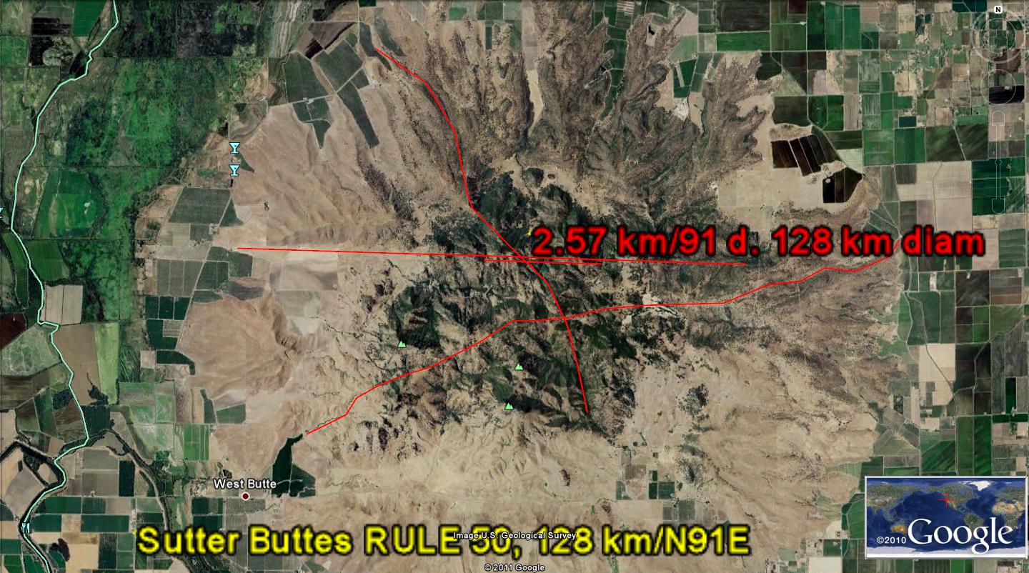
SUTTER BUTTES, CENTRAL VALLEY, CA is an irregular extrusion, created by LUNAR versus SOLAR offsetting EARTH TIDES

SUMMARY for solution of the SUTTER BUTTES extrusion of Pleistocene time:
Sutter Buttes results from an inflection in the trend of the Sierras to Cascades uplifts. Starting with the 45 degree turn from the Sierras trend to the Mendocino west movement, at 40N latitude, the offset of Lunar by the solar earth tides (20.48 vs. 10.24mm/year) created an opening in the crust. This occurred after the polar wobble started shifting at the 16 m.y. age until the diversion was completed at the Eltanin event. The opening can be seen on Google Earth as a linear passing through the buttes, with opposing arcs on either side.


SUMMARY: COINCIDENCE OF SHEAR AND ROTATION OF THE CRUST HAS MADE A "QUADRUPLE CONJUNCTION" AT SUTTER BUTTES. THIS HAS HAPPENED DURING THE QUATERNARY, OR SINCE THE LAST SIGNIFICANT ASTEROID STRIKE- ELTANIN. I HAVE FOUND THAT THIS STRIKE HAS WIDESPREAD INFLUENCE, SINCE IT EVIDENTLY HAD MANY FRAGMENTS (WHILE PENETRATING THE ICE AT ANTARCTICA). THE SHEAR AND ROTATIONS MAY BE VIEWED AT THE EXTRUSIONS, AS SLICKENSIDES, PARALLEL FRACTURES, AND MULTI-ROTATIONS OF INDIVIDUAL PROMINENCES. SEVERAL MILANKOVITCH CYCLES HAVE CREATED ROTATIONS OF THE REGION, AND THEY CAN BE SEEN AT THE BASE OF THIS BLOG. AN ELLIPTICAL ROTATION OCCURS IMMEDIATELY TO THE SOUTH OF SUTTER BUTTES, AND SEEMS TO BE ROTATING A PORTION OF THE CRUST ADJACENT TO IT. THIS FEATURE IS QUATERNARY OR STARTING LATE PLIOCENE, AND SB CALCULATES .63 M.Y. AGE.
ABOVE IS A GOOGLE MAP OF THE PACIFIC OCEAN TO SUTTER BUTTES, WITH SHEAR INDICATIONS FROM ROTATIONS SHOWN ON CONTINENTAL SHELVES. THIS PHOTO HAS SHEAR INDICATIONS WHICH ARE TOO SMALL TO BE OF VALUE TO INVESTIGATIONS FURTHER TO THE EAST IN THE CENTRAL VALLEY- THE LOCATION WHERE THE EXTRUSIONS OCCURRED.
WE WILL INVESTIGATE LARGER ROTATIONS TO FIND THE ONES APPROPRIATE TO DETERMINE THE STRAINS (THRUSTS AND LINEAR INDICATIONS OF MOVENENT) ASSOCIATED WITH THIS CONFLICT IN THE EARTH. GEOLOGISTS HAVE NOT BEEN ABLE TO FATHOM THIS ENTITY, AND WILL NOT BE ABLE TO UNDERSTAND IT WITHOUT RECOURSE TO A MODEL WHICH SHOWS THE MECHANICS OF MOVEMENTS. WE WILL TRY TO "FERRET OUT" OR PARSE THIS CONFLICT BETWEEN THE GREAT TRANSFORMS TO THE WEST AND THE MOVEMENTS AT THE EDGE OF THE SIERRAS-CASCADES REGIONS.

SUTTER BUTTES- AS SHOWN ON THE INITIAL MAP- HAS MANY SHEAR AND ROTATIONAL FEATURES; IT LIES NEAR AND IS PART OF THE GEYSERS GEOTHERMAL ROTATIONAL SPIRAL NEAR THE MENDOCINO MOVEMENTS:
Geysers field, CA is located at 38 degrees 47' 26N, 122 deg. 45' 21W


SUTTER BUTTES, CA, IS PART OF A DEVIANT from THE SIERRAS- ALL THE WAY FROM MENDOCINO 40N PROTRUSION TO THE WEST AND CORIOLIS ROTATION ANOMALY
The Sierras (NW-SE ORIENTED MOUNTAIN CHAIN, BETWEEN 34 AND 40N LATITUDES) ARE MOVING WESTWARD, BECAUSE OF THE INCREASED TIDAL DRAG ON THIS LATITUDE BAND. This occurs due to its greater protrusion into the atmosphere, where the TIDAL FORCE DRAGS ALL BULGES (SLOWS, RELATIVELY, ALL PROTRUSIONS) WESTWARD. Consequently, the segment of the CRUST between these latitudes is moving oppositely than the normal continental drag at the mantle top- which is to drag the crust east (with a simultaneous relatively slower movement of the top of the crust eastward). This normal eastward movement occurs because the mantle- being further from the MOON- moves somewhat faster than the crust (near 1 mm/year), and drags the crust at the lower boundary. As a result of all this, the segment between Los Angeles GARLOCK fault and Mendocino is moving westward (being higher in elevation)- creating several anomalies along the way. One of these is the angular change to the west at Mendocino (rotational) and another is the linear shown below:

A clue to the origin of SUTTER BUTTES IS SHOWN BELOW, WHERE TWO LARGER MOVEMENTS HAVE CREATED REACTIONARY CELLS WHICH WERE ROTATING AGAINST EACH OTHER, CREATING THE HEAT BY FRICTION NECESSARY TO CAUSE THERMAL UPLIFT AND EXTRUSION: A PRELIMINARY ANALYSIS OF THE FRACTURE TRENDS IS SHOWN BELOW. THIS WILL BE CHECKED IN THE FIELD, BY USING THE COMPASS TO MEASURE THE ANGLE, RELATIVE TO TRUE NORTH, MADE BY THE FRACTURES SEEN IN OUTCROPS (NOTICE THAT EAST VIEWS HAVE EITHER N-S OR NW-SE TRENDS):
SUTTER BUTTES IS SEEN BELOW AS A PART OF A LARGER ROTATION, WITH TWO CELLS ROTATING WITHIN THE VALLEY. THIS HAS CREATED THRUSTING ON A LARGE SCALE, AND A SINK WITHIN A CW-ROTATING CELL. This will have to be analyzed on a larger scale:
THE LARGER VERTICAL ROTATION WITHIN THE CRUST IS SEEN IN A DIAGRAM ON A STATE-WIDE VIEW, AND IT DIPS DOWN TO THE NORTH, WHILE BEING DRAGGED AT THE BASE BY THE MANTLE- WHICH MOVES TO THE EAST, DUE TO THE LESSER TIDAL INFLUENCE OF THE MOON:
THIS IS SHOWN DIAGRAMMATICALLY BELOW, AS A CROSS-SECTION OF VERTICALLY ROTATING EVENTS FROM MENDOCINO, CA TO OREGON:
THE GEYSERS ANOMALOUS AREA IS PART OF THIS PUZZLE. BELOW IS AN ANALYSIS OF THE FEATURE NEAR KELSEYVILLE, CA, WHICH PRODUCES STEAM FOR ELECTRICITY, AND WHICH IS SUBTLE IN ITS PRESENTATION. I HAVE ONLY PUT TRACES OF OBVIOUS ANOMALIES, AND WILL AUGMENT THEM AS WE INVESTIGATE THIS AREA SEPARATELY;

The solution of GEYSERS GEOTHERMAL SITE IS FOUND BY LOOKING AT A LARGER ENTITY- THE MOVING MENDOCINO LINEAR AT 40N LATITUDE WITH A CORIOLIS CELL ROTATING ABOUT IT, SIMILAR TO THAT FOUND FOR THE DISCOVERY FEATURE AT HURRICANE FAULT, UTAH: THE LARGE MENDOCINO CELL WITH A DIAMETER OF MORE THAN 500 KM, IS ROTATING SIMILARLY TO THE SMALLER ONE AT HURRICANE, UTAH SEEN IN AN ACCOMPANYING PHOTO- PRODUCING HEAT ON A MASSIVE SCALE (BUT NOT ENOUGH TO CREATE EXTRUSION).
Notice that the Sierras are moving westward, relative to surrounding parts of the CA state. They are also rotating CCW, so that the southern part moves 160 km, while the north part have moved about 100 km. How is this possible, when the whole range is moving westward? Indeed, the range is shoved by tidal forces acting on the high elevation mountains. This is a force created by the MOON'S TIDES, while the rotational force is one created by the spin of the EARTH. The boundary of the westward shove exists at 40N latitude, because of the termination of the equatorial bulge, EB. Above this latitude there is no large mountain range (until the Olympics are reached, and above that the Vancouver Island ranges). The latitudes between 40N and north Washington state have no high coastal ranges, hence are not dragged to the west (AS ARE THE SIERRAS), relatively.

BELOW IS AN "UNDOCTORED" VIEW OF THE CAPE MENDOCINO ACTIVE ZONE, WHERE CRUST SOUTH OF 40N SHEARS WESTWARD, AND NORTH SHEARS EASTWARD, YIELDING A CW ROTATION AROUND THE 40N EQUATORIAL BULGE TERMINATION, EB, WHERE MOVEMENT IS TO THE WEST FOR THE BULGE, AND RELATIVELY TO THE EAST FOR CRUST NOT HAVING A BULGE:
ANOTHER INTERPRETATION OF SUTTER BUTTES, AS TO HOW IT FITS IN THE GENERAL ROTATION AROUND THE 40N LATITUDE AND CIRCULAR SHEAR, IS SHOWN BELOW (THERE ARE SEVERAL INTERPRETATONS POSSSIBLE, BEFORE DOING THE FIELD WORK- TO FIND THE PARALLEL FRACTURE PATTERNS AND THE STRIATION-INDICATIONS OF MOVEMENT DIRECTION ON SLICKENSIDES):
NOTICE THAT I HAVE PLACED A CENTERLINE LINEAR AT THE APPROXIMATE CENTER OF THE CIRCLE OF ROTATION. I HAVE FOUND THAT THIS IS A WAY OF DETERMINING THE CENTER OF THE LARGEST SHEAR CIRCLE (YIELDING ITS DIAMETER). IN ADDITON, THIS SHOWS THE APPROPRIATE SHEAR CIRCLE, WHICH CAN BE FITTED TO THE FEATURE OF INTEREST:

ABOVE, I HAVE USED THE CIRCULAR PORTRAIT OF RIVERS AS THE PRIMARY TOOL FOR SHEAR INDICATIONS (RIVERS ARE FORMED PREFERENTIALY BY THE EASILY ERODED PATH ALONG ARCUATE SHEAR); SECONDARILY, WHEN THERE ARE NO RIVERS IN THE AREA OF INTEREST, I USE THE GOUGED ARCUATE TRACE IN VALLEYS AND LOWLANDS. ABOVE YOU CAN SEE THAT THERE ARE SEVERAL POSSIBLE PATHS; THIS IS WHERE FIELD WORK IS NEEDED TO FIND THE ACTUAL TRACE LEFT ON ROCK OUTCROPS, SUCH AS WITH PARALLEL FRACTURES, SLICKENSIDES, OR OBVIOUS THRUSTS.
NOW YOU CAN SEE THAT THE SHEAR MOVEMENT ALONG THE 40N LATITUDE TO MT. LASSEN (WHICH IS NOT QUITE A STRAIGHT LINE- DIPPING DOWN AND THEN TRENDING NE-WARD ALONG THE EDGE OF B&R FAULTING IN NEVADA) INFLUENCES THE REACTIONARY CELL. THIS HAS FORMED THE SUTTER BUTTES AND GEYSERS. REMEMBER THAT THE EDGE OF EB REPRESENTS AN UNCONFORMITY, WHERE MOVEMENT ALONG THE SOUTH SIDE IS WESTWARD- WHICH SHEARS ROCKS TO THE SOUTH AS MUCH AS 160 KM ALONG THE GARLOCK FAULT AND 100 KM AT THE 40N BOUNDARY. THE DIRECTION OF ROTATION MAY NOW BE DETERMINED FOR RC. IT IS CW, WHEN THERE ARE NO INTERVENING BUFFER CELLS TO REVERSE THE INDICATIONS. CAUTION! THERE MAY BE SMALL CORIOLIS CELLS BETWEEN SUTTER BUTTES RC AND THE 40N LATITUDE TRACE! VIEWING ANOTHER POSSIBILITY FOR THIS COMPLEX AREA:
NOTICE THAT I HAVE CHOSEN TO USE THE DEFINITE ROTATION SEEN ON GOOGLE EARTH AS THE DRIVING FORCE FOR OTHERS- WHICH ARE INLAND.
PARKED BELOW ARE SOME PHOTOS, TAKEN 3 MAY, WHICH SHOW ANOMALIES FOUND IN THE FIELD, COURTESY OF MIDDLEMOUNTAIN FOUNDATION AND THEIR FIELD GUIDE. THEY HAVE NOTICED OUTCROPS WHICH YIELD INFORMATION CONCERNING THE ROTATION AND SHEAR OF SURFACE ROCKS:
LATERAL AND VERTICAL SHEAR IS DEFINITELY OCCURRING IN THIS QUATERNARY FEATURE. BELOW ARE SHOWN SOME OF THE COMPLICATIONS OF THE DYNAMICS, WHERE EXHIBITED ARE THE INDIVIDUAL ROTATIONS AND SHEAR OF ONE OF THE LARGEST AND HIGHER PEAKS (NORTHEAST PEAK)- ONE AVAILABLE FOR INSPECTION BY HIKING INTO THE RUGGED RHYOLITIC AND ANDESITIC OUTCRTOPS: Below are my prognostications, BASED ON OBSERVATIONS MADE ON ACTIVE AND DORMANT VOLCANOES. WE WILL SEE HOW THEY PERTAIN AFTER VIEWING FRACTURES AND SLICKENSIDES IN THE FIELD:

SHEAR INDICATIONS ARE OMNI-PRESENT, BUT SLICKENSIDES STRIATIONS AS BELOW ARE RARE. THE TRENDS SHOWN ARE MAINLY LATERAL, BUT HAVE A VERTICAL COMPONENT. EACH PEAK HAS ROTATED SEPARATELY WITH DISTINCT PATTERNS (INDICATING EXTRUSIONS OCCURRING THROUGHOUT TIME). THESE ARE SIMILAR TO GLACIAL SCRATCHES, WHERE HARD PARTICLES IN THE UNSEEN FACE IN THE PAST HAVE SCRATCHED AGAINST THE EXHIBITED OUTCROP. THE PARALLEL-NESS IS THE MOST CONVINCING FEATURE, SHOWING THAT THE SPIRALING OF VERTICAL-MOVING RHYOLITE HAS PRODUCED ITS TRACE: BELOW IS ANOTHER VIEW OF THESE STRIATIONS, WHICH DIP DOWN 20 DEGREES TO THE SOUTHEAST:
I CLOSE FOR NOW WITH A VIEW OF THE NATURAL BEAUTY OF THE FOOTHILS OF SUTTER BUTTES. LET'S GET OUR FEET IN THIS AREA, LOSE SOME WEIGHT, UPLIFT OUR ASPIRATIONS, AND TOUCH NATURE, WITHOUT VANDALIZING IT. ENJOY FEATURES THAT ARE ALL AROUND US- SUCH AS THE BOTANY, GEOGRAPHY, GEOLOGY, AND ZOOLOGY OF THIS BEAUTIFUL LAND:
SIMILAR TO GLACIAL PLUCKING, THERE ARE DEPRESSIONS IN THE OUTCROP FACE, WHERE HARD PROJECTIONS ON THE MISSING (ERODED) FACE HAVE DRAGGED A SOFTER PORTION OF THE REMAINING FACE. THIS CREATES A "PLUCKING" ACTION, WITH THE WEAKER ROCK REMOVED. FURTHER DOWN, "OWLS EARS" HELPS TO IDENTIFY THIS SE SUTTER EXTRUSION, WHERE SHEARING HAS CREATED FRACTURES ORIENTED E-W. THIS IS DIAGONAL TO THE ONES EXHIBITING THE SLICKENSIDES, AND INDICATES THAT THERE ARE DIFFERENT ORIENTATION OF STRESSES ON OPPOSITE SIDES OF THE EXTRUSION:
ADDITIONAL INFORMATION IS SHOWN BELOW, WHERE A DEPRESSION OR SINK- RELATIVE TO THE SURFACE ON EITHER SIDE- OCCURS NEAR THE PERIMETER OF THE BUTTES. THIS WOULD BE THE CASE OF A CW ROTATION OF THE QUATERNARY EXTRUSIONS AS THEY CONTINUE TO SINK (SPIRALING DOWNWARD):
PERIPHERAL INFORMATION:
The regional tectonics of Northern California yields background from which the Sutter Buttes departs. Below are shown some photos from foothills near Auburn, which is 50 km to the south and east:
ASSESSMENT OF SUTTER BUTTES-MENDECINO GEOTHERMAL INITIATION INVESTIGATION
My original assessment of the “FIT” of the Sutter Buttes into a world-wide dynamics, due to Coriolis Rotation, Equatorial and Sierras Bulges Termination, and Drag of the Earth’s Crust with Mantle Differential velocity is shown below. Although I have not found anything to contradict my preliminary portrait, I have not done enough fieldwork to make positive conclusions.
Here is the initial assessment, found from Google Earth, from which all of the observations concerning Sutter Buttes were derived:
1. Rotation of the CRUST, laterally, due to Coriolis forces around the Mendocino 40N Latitude can be seen at Cape Mendocino, as a jutting of siltation at the Pacific Ocean continental slope- south of 40N
. North of Mendocino there is less protrusion of the slope, and the movement is opposite to that south of 40N. Combination of the two opposite movements (shearing) creates a CW rotation about 40N, and this drags the Crust on either side to create rotations, or REACTIONARY CELLS, RC, of various diameters;
2. The Equatorial and Sierras Bulges terminate at 40N latitude, yielding several phenomena:
A. Unconformity of formations below and above 40N (laterally, latitude-wise) and slickensides at the boundary
- indicate that there is continual shear of the Crust at the 40N bulge terminations (I have retrieved a rock sample from the Cape, photoed and shown in an earlier missive in this blog);
B. There is creation of earthquakes, lateral movement, and HEAT OF FRICTION, as the two segments move alongside each other;
C. Westward, movement on the south side of 40N creates drag of the Crust there, and this initiates large diameter extensions and translations
- the largest of which continues eastward to create rhyolitic extrusions from the common border of ID, NV, and UT to Yellowstone, Simultaneously, there is a movement of the Sierras westward, and this results in an extension (A PULLING APART) of the Basin And Range, B&R, to allow Mammoth Lakes Geothermal area to form and to create extrusion of violent rhyolitic emissions each million years or so (for a total of 13 sets of basins and Yellowstone-type extrusions until the Rocky Mountains are reached). It is assumed that the extension continues eastward, because of the protrusion of N-S trending mountain ranges which result in new extensions for each new protruding range;
D. Rotation of the RC south of 40N creates heat sufficiently to cause extrusion at Sutter Buttes, and subsequently Geysers geothermal field; this is a Coriolis cell of at least 100 km in diameter; and,
E. Extension of the B&R, with simultaneous rotation of the Sierras- causes the Central Valley to sink while the Sierras continue to rise.
3. The North Pacific basin exhibits shear along latitude lines, principally because the deep water absorbs the tidal effect, compared to continental crust being irregular and exhibiting consequent irregular movements
. The crust is thin under oceans, compared to that under continents, consequently shear lines in ocean bottoms are more regular (along latitude Ines for this part of the Pacific). Other ocean basins have associated bulges and do not portray the simplicity as does the North Pacific (Sahara bulge for the Atlantic, islands for the South Pacific, PTr strike for the Indian Ocean, and fragmentation of the Arctic; and,
4. Yellowstone geothermal phenomenon occurs due to extension, beginning in the Miocene after the Sierras instituted extension (AFTER SUFFFICIENT RISE OF THE MOUNTAINS). For each basin, with its accompanying rhyolitic extrusion at the northern head of each valley, there is eastward movement of the B&R, as a new protruding N-S linear range institutes new tidal shove to the west. This hints that rise of the Sierras began in the Oligocene, similar to the movement of the basalt vents westward from the Rio Grande rift (around the south and SW edges of the Colorado Plateau).
CONSEQUENTLY, THE RISE OF THE SIERRAS, THE UPLIFT OF THE COLORADO PLATEAU, THE FORMATION OF THE WASATCH LINE, THE INITIATION OF THE B&R, AND THE ROTATION OR BOTH B&R AND CP ARE INTER-CONNECTED (PROBABLY ORIGINALLY INSTITUTED BY THE INSTABILITY OF THE WOBBLE CREATED BY THE KT STRIKE IN YUCATAN).
BELOW IS A MAP OF THE WESTERN USA, WHERE THE FEATURES LISTED ABOVE ARE SHOWN. NOTICE THAT EVERYTHING IS INTER-CONNECTED, SHOWING THAT THE B&R, THE CP, THE SIERRAS, AND THE CASCADES FORM ROTATIONS WHICH EITHER HARMONIOUSLY ROTATE OR ELSE THEY CONFLICT- CREATING VULCANISM, GEOTHERMAL AN0MALIES, OR RECOGNIZABLE GEOLOGICAL FEATURES.


Sutter Buttes can be used to affirm the above preliminary assessments, if the following features can be shown:
a. That the entire SB outcrop can be shown to be rotating CW (cooling and shrinking vertically) NOW, COMPARED TO CCW ORIGINALLY;
b. That the present rotation fits into a general CW rotation of the entire circular cell from SB to the Mendocino 40N location;
c. That the N-S linear is a thrust, west of SB, with opposing shear on either side of this Kelseyville, CA (39N 122 22W) STRAIGHT-LINE feature; and,
d. That slickensides can be found for the circular feature, at least for four separate sides and locations.


Above is another possibility of the various Coriolis circular features, connected with the 40N latitude- Mendocino shear zone and rotation. Notice that some drainages turn southerly below the 40 latitude. This is expected, since the Sierras and Equatorial bulges terminate there, and there is discontinuity between the Crust to the north and south of this more-slowly moving Crust in the south (compared to the north, where there are no large mountain ranges, such as the Sierras, or EB to slow the Crust- relative to the faster-moving Mantle).
This is an extremely complicated zone, where EB, Sierras bulges, Vulcanism related to vertical rotation (oriented N-S), contrast of thickness of continental vs. oceanic Crust, and rotation of the Sierras CCW all interact to produce many circular portraits of rivers, lakes, shear valleys, thrusts along I-15, and in the foothills.
However, I am confident that after considering all of the possible rotations and interactions, that I can sort this out to produce the most likely scenario creating vulcanism, thrusts, shear between Coriolis cells, and lateral folds.
A critical factor is that of finding in the field the various slickensides, parallel fracture pattern, concrete slab lateral shear indications, and the direction of shear on four (or at least 3) sides of Sutter Buttes. I have found that Google Earth photos are excellent for determining the circular features in the crust, but that the direction of spin, or rotation of cells may be diagnosed to be backwards without field evidence. Even then, cat steps or claw marks may be difficult to diagnose. But one rule has proven to be inviolable: rising features (salt domes, active volcanoes, and uplifting regions) rotate CCW, while sinking crust (basins, depressions and sinkholes) rotates CW.


THE REGIONAL TREND OF SHEAR AND STRESS IS NW-SE, SIMILAR TO THE COASTLINE OF WESTERN CA AND OF THE SIERRAS (THEY ARE MOVING WESTWARD, WHILE ROTATING CCW):

Above and below are photos taken near the DEADMAN CREEK AND ITS INTERSECTION WITH A LARGER STREAM:

Incidentally, this appraisal has yielded information necessary to solve the SUTTER BUTTES ANOMALY- which is not understood by field geologists. I now see that there is another transform south of the 40N Mendocino location which bears on the rotation, shear and extrusion of basalts at this SB location.


I have analyzed the EO strike, after having done hiking and investigation of the 41 m.y. and younger movements. This age is taken from a major transform in the North Pacific Ocean, where the age has been measured for the Kimmei seamount at the focus of the transforms. Although this age is older than the EO boundary at 34 m.y., it seems that fossil evidence occurs somewhat later than the mechanical action of a strike. Consequently, I have re-analyzed the British Columbia antipode found for the EO strike in the Indian Ocean. There is strong evidence from transforms being diverted in a deep part of the basin- 3 miles depth- that there was a strike at the oppositely-located position of the crust at 58S 68E location (French Southern Islands).


Inspection of the EO antipode in BC and Alberta indicates that there was spiraling of a basin, and that likely the orientation of features in the USA would react to this movement. I have plotted the path of the reaction, as indicated by the 41 m.y. transform at 40N and Mendocino, CA; this indicates that the shear was accelerated by the event- noticed and measured for age at the Kimmei seamount. My general assessment for asteroids and their path as shown by transforms in the ocean basins, is that the STRESS IS PRESENT IN ADVANCE OF THE ASTEROID, BUT THAT IT IS ACCELERATED (CREATING STRAIN OR MOVEMENT ALONG TRANSFORMS) BY THE STRIKE.
Notice that there are concentric circles of shear- as evidenced by patterns of river valleys and faint traces which have been “farmed over” leaving circular indications. The region presents a pattern somewhat similar to that of the KT strike and the Gulf of Mexico: there is basin to the right of the strike and another east of the antipode (in both cases).
Incidentally, this appraisal has yielded information necessary to solve the SUTTER BUTTES ANOMALY- which is not understood by field geologists. I now see that there is another transform south of the 40N Mendocino location which bears on the rotation, shear and extrusion of basalts at this SB location.

NW USA IS INFLUENCED BY THE EO STRIKE OF 34-41 M.Y. THROUGH OREGON (FOSSIL EVIDENCE), NORTHERN CA, AND WA. THERE IS VERTICAL ROTATION OF THE CRUST FROM CA (MT. LASSEN) TO THE CANADIAN BORDER- WHERE THE ANTIPODE OF EO IS MOST INFLUENTIAL. THIS IS SHOWN BELOW BY GOOGLE PHOTOS AND BY DIAGRAM LATER:


BY DIAGRAM, FOR GENERAL AS WELL AS LOCAL ROTATIONS, VERICALLY AND HORIZONTALLY:

ASSESSING THE LARGER PICTURE OF THE MOVEMENTS FROM MENDOCINO 40N LATITUDE TO PIONEER RIDGE TO THE SOUTH, THERE ARE TWO SIGNIFICANT (LARGE DIAMETER SHEAR CIRCLES) MOVEMENTS TOWARD THE GEYSERS GEOTHERMAL FIELD. "ODDS ARE" THAT THERE ARE TWO INTERFERING SHEAR CIRCLES (LATERAL, WITH HORIZONTAL DISPLACEMENT) AT THE SHALLOW CRUST NEAR KELSEYVILLE, CA. WE WILL PROCEED FROM THESE, TO SEE WHETHER THIS LEADS TO THE PLIOCENE EXTRUSION AT SUTTER BUTTES:


SOLVING THE ENIGMA OF SUTTER BUTTES EXTRUSION IS MADE EASIER BY USING A PROXY: THE OCCURRENCE OF A SIMILAR EXTRUSION, WHICH IS MORE EASILY HIKED, PHOTOGRAPHED, AND VIEWED AT CLOSE HAND. THE PROXY IS LEEDS VOLCANO- A NOT-YET-DOUBLY-EXTRUDED PLEISTOCENE BASALTIC VOLCANO. I CAN DRIVE TO THE EDGE OF THIS BASALT OUTCROP AND HIKE IT IN A MORNING. IT HAS MANY SIMILARITIES: A SPLIT CONE, WITH AN EASILY DISCERNED ORIGINATION SITE, OBVIOUSLY CW-ROTATING AND COOLING ARCUATE FEATURES, AND GOUGE ZONES, WHICH ARE BEING DISCOLORED WITH THE CHEMICAL WEATHERING. THIS IS SEEN IN THE 2ND PHOTO DOWN, BUT FIRST, VIEW A SMALLER YET SHEAR ZONE IN THE NE CORNER (WHICH IS THE CASE FOR LEEDS, BUT A DIFFERENT ORTHOGONAL BLOCK) OF SAND MOUNTAIN-HOLLOW- TO THE SOUTH OF THE VIRGIN RIVER:


LEEDS PRESENTED IN A DIFFERENT MAGNIFICATION:


NOW THAT YOU ARE "PRIMED" WITH THE ASSOCIATION OF NE CORNER OPENINGS AND SHEAR FEATURES, VIEW SUTTER BUTTES AS A NE CORNER FEATURE:


SOLUTION TO SUTTER BUTTES OCCURRENCE: INTERFERENCE OF 2 SHEAR CIRCLES
I have found that there is a ratio between the separation of shear linears and the diameter of the arc creating the GRID. It is 50:1, where the relation is developed by the present stress state created by the latest asteroid- the 2.15 m.y. ELTANIN event.

The case of Sutter Buttes has several parallel gridlines or linears, on a scale where they appear to be straight lines, but which actually are curvilinear on a larger view. The curvilinear feature is a circle, which usually incomplete (presently forming), and which denotes the rotation of a reactionary cell, RC. RC may be a Coriolis cell, or it may be “DRAGGED” BY SOME LARGER MOVEMENT. Sutter Buttes has a common linear oriented toward the Geysers geothermal field, which is shown below:


Sutter Buttes and Geysers 128 km radius
The circumference is not so obviously visible, and it is subverted by other dynamics away from the arcs shown, but nevertheless is operative for the Sutter case. Below is the 2nd shear circle, found by photo of the contrasting parallel gridlines:


THERE ARE FOUR ARCUATE FEATURES INFLUENCING SUTTER BUTTES: 2 TO THE NORTH-SOUTH AND 2 TO THE E-W. THESE WOULD NOT BE NOTICED BY GEOLOGISTS, SINCE YOU MUST HAVE THE CRITERIA IN ADVANCE TO FIND THEIR LOCAL INFLUENCE. THE SHEAR AND ROTATION ARE PARTLY DETERMINED AS A REACTION TO THE ROTATION OF MT. SHASTA (WHICH IS IN TURN PROBABLY ASSISTED BY THE ELTANIN STRIKE OF 2.15 M.Y. AGE. DON'T ATTEMPT TO USE THIS RELATION FOR OLDER STRIKES, SINCE THE MULTIPLES WILL BE DIFFERENT. FOR EXAMPLE, THERE IS A 6 M.Y. STRIKE WHICH RAISED CEDAR BREAKS, AND ITS TIME CYCLE HAS ANOTHER MULTIPLE. CONCENTRATE ON THE ONE AT HAND- THE INTERFERENCE OF FOUR ROTATIONS WITH EACH OTHER, ALL OF WHICH CAN BE SEEN AS PARALLEL FRACTURES, (AND LATERAL FAULTING) ON DIGITAL PHOTOS OR ON GOOGLE EARTH.


THE LATERAL SHEAR HAS MOVED WESTWARD WITH TIME, SINCE BOTH SUTTER AND MT. SHASTA HAVE COOLED (ROTATING CW), AND THRUSTING HAS BEEN ACTIVATED TO THE WEST- DRAGGED BY THE MENDOCINO MOVEMENTS. HENCE THE HEAT IS BEING GENERATED BY A NEW SET OF ROTATIONS:


Sutter Buttes and Geysers 128 km radius
The circumference is not so obviously visible, and it is subverted by other dynamics away from the arcs shown, but nevertheless is operative for the Sutter case. Below is the 2nd shear circle, found by photo of the contrasting parallel gridlines:


THIS ANALYSIS HAS NOW INCORPORATED "MILLAKOVITCH CYCLES" AND THE TWO THAT ARE OF MOST CONCERN ARE CALCULATED TO HAVE STARTED IN LATE PLIOCENE, OR AT THE BOUNDARY OF QUATERNARY:
Applying THE LATEST DISCOVERY of www.Quadransphere.blogspot.com we are now able to measure the AGE OF INDIVIDUAL SHEAR ROTATIONS AT SUTTER BUTTES (there are many, and there are some CAVEATS TO THE CALCULATIONS). EARTH TIDES NORMALLY ARE 20km/m.y. for regions where PARALLEL GRID LINE DISPLAYED (EASILY VIEWED IN OCEAN BASINS). The FIRST CAVEAT
1. IS THAT VOLCANOES OCCUR WITHIN AN ELLIPTICAL ROTATION, CAUSED BY GRAVITATIONAL DEVIATION WITHIN THE SOLAR SYSTEM. WHENEVER THE LARGE PLANETS "ALIGN", THE ELLIPTICAL SHEAR FEATURES ARE ACCENTUATED.


LEEDS VOLCANO HAS 2 SEPARATE DOMES WHICH WERE BELCHED BOTH WITHIN A FEW THOUSAND YEARS; THESE ARE MARKED BY A DIVIDING LINEAR, WHICH IS THE LOCATION OF THE ORIGINAL LINE SEPARATING THE SOLAR EAST TIDES FROM THE LUNAR WEST TIDES. I AM EXPLORING THIS FEATURE, WITH THE INTENT TO FIND WHETHER THE LINEAR OPENED THE CRUST ALL THE WAY TO THE MANTLE- ALLOWING NORMALLY HOT BASALT TO SIMPLY EMERGE BY BUOYANT RISE OF THE LIGHT MAGMA. THIS IS THE SIMPLEST CASE WHERE BASALT RISES UPON ENCOUNTERING AN OPENING (PIPE OR CONDUIT) TO THE ATMOSPHERE. THE DIVIDING LINEAR WOULD NOT BE A CURVILINEAR, BUT WOULD BE A LIMITED EXTENT LINEAR, CREATED BY THE 45 DEGREE TURN TO THE LEFT OF THE VIRGIN ANTICLINE (CORRELATED WITH THE 2 M.Y. ELTANIN EVENT OR LATER):


THIS IS SHOWN IN OBLIQUE VIEW, SO AS TO ALLOW A 3D ANALYSIS.


SUTTER DOES NOT SHOW AN ELLIPTICAL FEATURE, AND THIS MEANS THAT THE 2ND LARGE EXTRUSION HAS NOT YET OCCURRED. IT WILL LIKELY OCCUR WITHIN 1 M.Y. OF THE ORIGINAL, AS FOUND ON THE HAWAIIAN ISLANDS, AND PROBABLY ERUPT ON THE SOUTH SIDE OF SUTTER BUTTES, WHERE THERE IS PRESENTLY A RISE AND ACCOMPANYING GAS FIELD. SEE THE GOOGLE PHOTO BELOW:

2. USE OF 20KM/M.Y. FOR ELLIPSES ENTAILS ERRORS, OF TWO TYPES:
A. ELLIPSES CONTAIN AT LEAST 2 ROTATIONS, PERTAINING TO THE AXIAL AND PRECESSIONAL CYCLES OF 40 AND 25 M.Y. THE 20 DIVISOR TO AGE CALCULATIONS CAN ONLY BE USED FOR THE AXIAL, WHICH HAS A REGULAR DISPLAY OF 40 K.Y., OR FOR HARMONICS OF THIS REGULARITY;
B. THERE ARE NO CONSTANT GRID LINE SEPARATIONS FOR VOLCANOES, THRUSTS AND REBOUND.
3. WHENEVER A "TOO LARGE" DIVISOR OF 20 IS USED, THE AGE CALCULATION WILL BE LOW IN NUMBER OF YEARS. TO FIND THE APPROPRIATE DIVISOR, ONE MUST GO THROUGH THE CALCULATIONS TO OBTAIN THE APPROXIMATE DIVISOR, AND THEN ADJUST THE CALCULATIONS APPROPRIATELY. FOR EXAMPLE, FOR REBOUND AND THRUST FAULTING, AS AT WHIDBEY AND SAN JUAN ISLANDS, THE DIVISOR VARIED FROM 10 FOR THRUSTING, DOWN TO 1 FOR UNLOADING OF ICE (MASS RE-DISTRIBUTION);
4. IT IS LIKELY THAT THE DIVISOR IS 10 FOR SUTTER BUTTES, AFTER ALL MY CALCULATIONS ARE ADJUSTED FOR "CHATTER" OCCURRING FOR VULCANISM, REBOUND, AND THRUSTING. CONSEQUENTLY, THE AGES CALCULATED ARE ERRONEOUS BY A FACTOR OF 2 (1/2 M.Y WOULD MORE LIKELY BE 1 M.Y).


Another way of ANALYZING Sutter Buttes involves the POLYGON EXHIBIT. I have found that most of what I have CALCULATED from ARCUATE ROTATIONS consists of a series of "JERKS" large and small. The SIMPLEST CASE exhibits these LINEARS (as with LATERAL THRUSTING) in a COMPLETE POLYGON. Sutter Buttes has these presented excellently on the SW, W, and NW sides, but incompletely on the NE and SE sides. This indicates that the 3.8 m.y. development is not complete, and the NEARBY GEYSERS GEOTHERMAL FIELD tells a similar story. Look at the ON-GOING MOVEMENT and it is clear that the DIAMETER of the POLYGON can be determied, but not the entire polygon. With this measurement, the approximate PERIMETER can be used to calculate the APPRROXIMATE AGE= PERIMETER/tidal rate of that from trigonometry of 10-12 degrees from DUE E-W:

The 2 EARTH TIDAL LINEARS are almost parallel (within 2 degrees by the compass), and yield a measure of CONFIDENCE to the procedure:
Also, the ORTHOGONAL TRACE overlies a faint DIVIDER of the EXTRUSIONS:
What can we determine from the UNFINISHED POLYGON- the MISSING LINEARS?


Above Google photo indicates that the NE side of the polygon (which rotates at a smaller RATE= 14mm/year) is in DEVELOPMENT, partly since there is an INTERFERENCE from other SOLAR MASSES (2 ratio pertains to Mars, 1.62 to Venus, and 2.5 to Jupiter).


LEEDS VOLCANO HAS 2 SEPARATE DOMES WHICH WERE BELCHED BOTH WITHIN A FEW THOUSAND YEARS; THESE ARE MARKED BY A DIVIDING LINEAR, WHICH IS THE LOCATION OF THE ORIGINAL LINE SEPARATING THE SOLAR EAST TIDES FROM THE LUNAR WEST TIDES. I AM EXPLORING THIS FEATURE, WITH THE INTENT TO FIND WHETHER THE LINEAR OPENED THE CRUST ALL THE WAY TO THE MANTLE- ALLOWING NORMALLY HOT BASALT TO SIMPLY EMERGE BY BUOYANT RISE OF THE LIGHT MAGMA. THIS IS THE SIMPLEST CASE WHERE BASALT RISES UPON ENCOUNTERING AN OPENING (PIPE OR CONDUIT) TO THE ATMOSPHERE. THE DIVIDING LINEAR WOULD NOT BE A CURVILINEAR, BUT WOULD BE A LIMITED EXTENT LINEAR, CREATED BY THE 45 DEGREE TURN TO THE LEFT OF THE VIRGIN ANTICLINE (CORRELATED WITH THE 2 M.Y. ELTANIN EVENT OR LATER):


THIS IS SHOWN IN OBLIQUE VIEW, SO AS TO ALLOW A 3D ANALYSIS.


SUTTER BUTTES, CENTRAL VALLEY, CA results from an opening created by Lunar westward vs. Solar eastward tides:
Photo above shows the arcuate presentation of shear rotations created by EARTH TIDES. These commenced after 3 m.y. (probably related to the ELTANIN EVENT), and have pulled the crusat apart at a rate of 10.24 mm/year, NET. The lunar rate of 20.48 is offset by the solar pull to the east, which is exactly half of the normal westward tidal- as developed by the BINARY THEOREM. This phenomenon occurs ONLY in the NE quadrant of a rotating block of crust, and has been observed for all quadrants I have examined: Gulf of Mexico, Sand Mountain, UT, Offshore channel islands, CA, Loihi, HI offshore Hawaii, and the Aleutian Spiral.

Earth Science, in Quadra-meter

The Globe from space, truly’s a beauty-
(which, thought in field, is naught but duty)-
But requires a search to de-ossify,
With great renown, a bone to classify.

But seen as ART, Makers assure,
The whirls and mounds are Beauty pure;
They spiral around, creating Fire,
Which to the Aesthetician can inspire

The lowly worker on the ground
To search the rigid rocks profound,
For secrets more than grains- mundane
(Which spread their dust across the plain).

The Orb’s a sphere, and almost clean;
It daily rectifies defilement mean,
And eliminates the intent of greed
To accumulate materialistic Deed

To that which fills a constant need
In lieu of fragrance - Rose and seed-
Giving LIFE another chance to breed
For Beauty, Poetry, ’n Art indeed.

Poets return to IDEAS beautiful
Away from Geology’s Do t’fool;
The easy way’s to stop the budget
Then there’s no longer need to fudge’t.

Harold L. Overton


THIS WILL BE AUGMENTED AS ADDITIONAL INFORMATION IS FOUND IN THE FIELD.