Thursday, October 6, 2011

ATMOSPHERIC WEATHER CELLS MAY be used as MODELS for CORIOLIS ROTATIONS and EARTH TIDES IN CRUST


BELOW ARE EXAMPLES OF "ATMOSPHERIC TIDES", WHICH ILLUSTRATE THE PRINCIPLE THAT CORIOLIS FORCE, POLAR WOBBLE, AND MILANKOVITCH-TYPE CYCLES AFFECT NOT ONLY THE CLIMATE, BUT ALSO THE DAILY WEATHER, THE CURRENTS IN THE SEAS, AND THE CRUST BELOW ALL THIS. ATMOSPHERIC MOVEMENTS ARE RELATIVELY FAST- DUE TO THE LOW VISCOSITY COMPARED TO THAT IN WATER OR RESISTANT ROCK. THE AIR MOVEMENTS ARE AT LEAST 10 EXPONENT 8 TIMES FASTER THAN THOSE IN ROCK (AIR:WATER:ROCK= 1:100:10 EXPONENT 10 RATIOS).
A ROUGH CALCULATION OF THE DAILY RATE OF UPPER AIR MOVEMENT MAY BE CALCULATED FROM THE BELOW PHOTO FROM SPACE: DURING THE PERIOD OF 50 HOURS SINCE THE LATER PHOTO WAS TAKEN, THE JET STREAM HAS CREATED A LARGER DIAMETER CIRCLE AND HAS MOVED 80KM/HR OR 50MPH. THIS TRANSLATES INTO 7 X 10EXP 5 KM/YR. THE RATIO OF EARTH TIDE MOVEMENT TO ATMOSPHERIC MOVEMENT IS APPROXIMATELY 7.85 X 10EXP -10 (INVERSELY, 1/3 X 10EXP 8 TIMES AS FAST).


THE ABOVE PHOTO FROM SPACE INDICATES THAT SOME FEATURES, SUCH AS ISLAND ARRAYS, CROSS THE EQUATOR. HENCE DYNAMICS OTHER THAN CORIOLIS EFFECTS ARE INVOLVED:

Confirmation of Ocean Basin dynamics via Summer and Winter Coriolis Behavior
A valuable tool for use with Coriolis analyses is that of the atmosphere- which is subject to the same Earth Dynamics as the Crust of the Earth. Although the atmosphere touches only the sea bottom and the continents (AND NOT THE MANTLE), WEATHER-RELATED CELLS are initiated by the same forces from the SPIN OF THE EARTH. The crust touches both the ATMOSPHERE AND MANTLE, and if you believe that the principal motions of the crust are due to Coriolis effects, then you only have to concern yourself that the Mantle is forcing the base of the crust eastward (since it is rotating a bit faster than the crust, with its greater distance from the tidal influence of the MOON). There are other dynamic influences on the rotating crust: BULGES SUBJECT TO EARTH TIDES (SIMILAR TO MOUNTAIN CHAINS), CONTRACTION OF THE EARTH AS ITS SPIN RATE SLOWS, GEO-MAGNETIC PULSING AND STRIPING, AND ASTEROID STRIKES. The last two categories are out of my ability to analyze, and we will concern ourselves with the first 2 categories- tidal slowing of protrusions and contraction of the earth with length of day (LOD). The crust re-arranges itself (OTHER THAN BY CORIOLIS ROTATION- THE PRIMARY INFLUENCE) due to MANTLE DRAG AND MOUNTAIN-AUGMENTED CRUSTAL SHEAR (MAD-MACS).

NOW LOOK AT A VIEW FROM SPACE, ORBITING OVER A FIXED POSITION, SO THAT WEATHER CELLS MAY BE EXAMINED OVER THE PACIFIC OCEAN- THEIR BREEDING GROUND (INDICATING THEIR INCIPIENCE, NOT THEIR LATER INTERACTION WITH TERRAIN):
This photo was taken with a FULL MOON, SO THAT BOTH MOON AND SUN ARE ATTRACTING (MORE SO THAN AT OTHER DAYS) THE EARTH NEAR THE EQUATOR. HIGH AND LOW CLOUDS REFER TO ALTITUDE, AND NOT HIGH PRESSURE. NOTE THAT THE HIGH CLOUDS CROSS OVER THE WEATHER CLOUDS, CONTINUING ACROSS THE EQUATOR. THIS MEANS THAT CORIOLIS IS NOT THE DRIVING FORCE; RATHER THE MOON OR THE SUN IS CREATING UPLIFT ON LOCATIONS EXHIBITING ISLAND ARRAYS. WE WILL TRY TO DETERMINE WHETHER THE MOON ALONE IS ABLE BY ITS SMALL ANGLE WITH THE ECLIPTIC, TO PULL ON THE SOUTH SIDE OF THE EQUATOR MORE SO THAN ON THE NORTH SIDE. POSSIBLY THE ADDITION OF THE SUN'S GRAVITATIONAL PULL HELPS THIS BEHAVIOR, AND POSSIBLY THE SUN CREATES THE CIRCLE OF SEAMOUNTS NOTICED ALONG THE TROPIC OF CAPRICORN.
Below is a diagram which simplifies the annual path of the EARTH-MOON DUO, as it SPIRALS IN THE CONFIGURATION OF A SCREW or VORTEX. We will try to answer two QUESTIONS:
1. DOES THE EARTH PRESENT THE FACE OF THE SOUTH PACIFIC TO THE MOON THROUGHOUT MOST MID-DAYS OF THE YEAR (compared relatively, to the North Pacific); and,
2. IS THERE A RIGHT-HANDED SCREW OVER THE MONTHLY PERIOD (ROTATING, LIKE A TWIST WITH YOUR RIGHT HAND- CLOCKWISE)?

AGAIN, A COMPARISON WITH WEATHER PATTERNS FROM A SPACE VIEW ARE COMPARED WITH THE TREND OF SEAMOUNTS IN THE SOUTH PACIFIC OCEAN:
BELOW ARE TWO PHOTOS FROM SPACE, SHOWING HOURLY CLOUD CHANGES FOR THE PACIFIC:

Island Arcs and Linears in the South Pacific
There are arrays of islands in the South Pacific eastward until reaching Easter Island (compared to almost none east of Hawaii- in the North Pacific)
. This ignores the islands close to South America, SA, such as Islas Juan Fernandez, and more importantly, Galapagos at the Equator; but more on these later. These arrays exhibit great circles when viewed on a larger scale. At close Range, a portion of a circular configuration appears to be a LINEAR, and the curvature of the earth is involved, so that for geographical purposes we can not easily distinguish these features in the field.
The question to ask, concerning these arrays is: What is the incipience of these arrangements? According to the above photos of weather cells, there are similar arrangements of clouds, which are taken at times during the day when the sun is overhead (or nearly so), and which clearly are the result of HEATING. However, when the same portraits are seen during earlier and later hours, and they remain, this indicates that the movement of the sun overhead has little effect on the portrait! It is expected that the daily movement of the sun from east to west would create a moving circle of cloud arrangement, and this is true for continents. However, over the Pacific, it appears that there is an arrangement which is maintained, regardless of sun movement. Notice the CIRCLE OF CLOUDS, WHICH ENCIRCLES THE SOUTH PACIFIC, CROSSING THE EQUATOR.
The Moon is involved in this arrangement, so that until we can determine whether it attracts the CRUST SOUTH OF THE EQUATOR MORE THAN THAT IN THE NORTH, we can’t be sure that the portrait of circular islands is due to the moon, the sun, or to a combination of the two. However, there are at least two of these circum-Pacific arrays, so that possibly one is due to the sun (where the south border of the circle is near the TROPIC OF CAPRICORN). The moon-earth center of mass lies in the earth’s mantle, and the helix made by the monthly spiral about the ECLIPTIC could attract the crust south of the equator more than in the north- creating this mass of islands in the South Pacific Ocean. The arrangement is not altogether linear there, but exhibits islands over a large area. This is probably a rising area, created by attraction of spatial masses- either sun or moon. This is strongly indicated by the way in which the cloud pattern diverts around the array of islands- indicating a bulge in the EARTH’S CRUST.

PHOTO ABOVE INDICATES THAT THERE IS CIRCULATION OF WEATHER CELLS, WHICH ARE SOMEWHAT INDEPENDANT OF THE SUN'S POSITION, REMAINING DAILY! THIS IS SURPRISING, BUT IS SIMILAR TO THE ARRAY OF SMALL ISLANDS BETWEEN THE TONGA TRENCH AND S. AMERICA.
ANOTHER FACET TO CONSIDER IS THAT OF THE SHAPE OF THE GLOBE,IN THE SOUTH PACIFIC- THAT OF A PEAR-SHAPED EARTH: NOTE THAT THE SHAPE OF THE GLOBE INFLUENCES NOT ONLY THE WEATHER, BUT THE EMERGENCE OF SOUTH PACIFIC ISLANDS. WE WILL TRY TO DISCERN THE IMPETUS OF THIS RISE- IS IT DUE TO THE HELICAL PATH OF THE MOON ABOUT THE ECLIPTIC, OR IS THE SUN INVOLVED?

THIS ANALYSIS WILL BE CONTINUED; SCROLL DOWN FOR INFORMATION LEADING TO MORE UNDERSTANDING:

Thursday, September 29, 2011

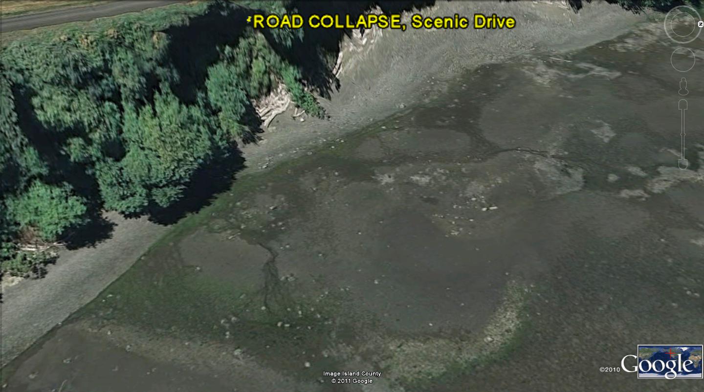
ROAD COLLAPSE, due to EARTH TIDES and POLAR WOBBLE


Whidbey Island is particularly susceptible to shear and rotation of the crust of the earth, with MILANKOVITCH-type cycles resulting from POLAR WOBBLE. A visible result of all this occurs in concrete slabs, artificial structures- such as roads, and in circular shear of cliffs and valleys.
The above digital photo was made off HIWAY 20, south of the intersection of Scenic Road and Pioneer (the main thorofare in Oak Harbor). This road has been condemned due to the continual slumping and sloughing of the asphalt at the cliffs overlooking Oak Harbor Bay. There are houses to the west, and a resident who has live there for 30 years, provided many details of the behavior of the hills west of the cliffs shown. She reports that her SE house corner has noticeably sunk- leaving cracks, and that there were seeps in the pasture behind her house. There are springs running now, in the gravels below the cliffs (too high for the daily tidal surge).
The cliffs are about 8 meters high, and are vertical, because of the yearly shear. These are shown below, with remarks about the indicated convex (outwardly) bulges and the concave (inwardly) curvatures in the cliffs. These must be interpreted in terms of what has transpired since the ICE AGE. During the ice buildup, the surface was compressed downwardly (CW sinking with the added weight), and has subsequently REBOUNDED CCW, with water transferred to the seas. This causes CHATTER, which is an opposing force to normal EARTH TIDES- that are shoving the crust WESTWARDLY. Consequently, the open ocean 20km/m.y. movement is reduced to a VARIABLE- which must be measured for the local area. This can be initially approximately with the MEASURED separation of GRID LINES, which orient N-S and E-W, and can be measured on Google Earth in both directions. The N-S lines are not disrupted by Latitude or Solar Tides, as are the E-W lines. Their spacing is smaller than the 20km/m.y. movements noticed in continental regions, such as near the Hurricane Fault, Hf:

This is ENLARGED to view the SHEAR ROTATIONS, CREATED BY POLAR WOBBLE, as exhibited by MILANKOVITCH-TYPE CYCLES:

The cliffs are vertical, with bulges extending to the east, and concavities adjacent to the bulges. These indicate sinks for the concave rotations and rises (rebound or uplift) for the bulges.
VIEWING THE OPEN WATER IN OAK HARBOR BAY, THE ARCUATE CROSSING OF "CHATTER" LINES, OR RIDGES, MAY BE SEEN TO INDICATE SPACING (WHICH MAY BE ANALYZED FOR TIME OF INITIATION; SEE ARCUATE CROSSINGS AT PUGET SOUND, EAST OF SILVER LAKE, IN A PREVIOUS BLOG SUBMISSION) AND UPLIFT-SINKING GRID LINES ALTERNATIVELY EXHIBITED:

OTHER GOOGLE EARTH VIEWS ARE SHOWN BELOW, TO GET A VERTICAL AND AN OBLIQUE PERSPECTIVE:

THIS AREA MAY BE HIKED, AFTER PARKING AT THE CLOSEST SPACE ON SCENIC DRIVE, SOUTH OF HIWAY SR20. YOU NEED A ROPE LADDER TO DESCEND TO THE BEACH, OR YOU MAY DROP TO THE BEACH BACK TO THE NORTH- WHERE THE TIDELANDS ARE OPEN TO THE PUBLIC. BRING A GPS LOCATOR, A COMPASS, CAMERA, HIKING BOOTS FOR THE ROUGH TIDAL ZONE, AND A HIKING POLE. YOU MAY VIEW ALL THIS FROM MAYLER POINT (HOUSING AREA) NAVY RESERVATION TO THE EAST ABOUT 1 KM. MAYLER IS AN ATROPHIED TOMBOLO, WHICH HAS PROGRESSED TO BECOME A PENINSULA RISING WITH REBOUND, WITH ITS OWN THRUSTS, UPLIFTS, AND CURVILINEARS


SUMMARY of Scenic Drive, Oak Harbor ROAD COLLAPSE:
Scenic Drive had a metal post-barricaded border which has collapsed, along with the eastern portion of the road. This could be dated, and it has sheared away from the road in the 50 years since installation. This represents about 10 cm/year migration of the cliffs to the west, and this can be measured by the thickness of the blocks which have sheared away from the cliffs below the road. These cliffs shear intermittently- not necessarily every year.
The cliffs are vertical, except for bulges and cavities; the bulges represent rotations vertically, as do the cavities- both shearing in opposite directions (bulges easterly, or CCW, with shear developing between those planes (vertical slices) rotating oppositely.
Land or Earth Tides, similar to water tides, move the cliffs westerly- up to 20mm/year; the 200mm/year observed for Scenic Drive is excessive, and probably indicates a ten year cycle (at least) for “jerks” or CHATTER of opposing movement against the normal 20mm/year.
Horizontal arcuate features can be seen on the Bay bottom, with digital photos and Google Earth scans. These are similar to Mima Mounds, with arcuate features crossing each other in a diffraction-type pattern. They can be analyzed with photos from a digital camera or Google Earth. They result from transfer of mass of ice from the ICE AGE to the sea laterally- yielding CHATTER, or reduced earth tidal movement yearly. The chatter has been calculated to occur on a 1000 or more YEARLY cycle, after the ice has been moved- to create a rare and mass-shift POLAR WOBBLE. The resulting shift to the west is on the order of 1mm/year or more (less than 20mm/yr.).
Processes observed locally can be used as a general tool for predicting shear and sloughing of roadways and cliffs. It occurs where there are observable arcuate traces in the bays and waterways near cliffs. This can be predicted for the eastern shorelines of islands, as well as for any cliffs convex to the west, or concave to the east.

BELOW IS AN ANALYSIS OF ROAD COLLAPSE IN A REGION FAR FROM WHIDBEY ISLAND. THE SAME FEATURES ARE DISPLAYED ALONG THE VIRGIN RIVER, UT, AS WITH THE OAK HARBOR SHEAR: A SINKING CW ROTATION ALONGSIDE A RISING LAND PORTION, SHEAR MARKS IN THE TRAIL PARALLEL TO THE GENERAL ROTATION OF THE AREA (SHOWN BY THE WATER'S EDGE), AND A DEMARCATION OF THE HALF-WAY POINT IN THE DISRUPTION OF THE CYCLE. THIS CALCULATES A 50K.Y CYCLE, AND MY ERRORS ARE SUCH AS TO ADVISE THAT IT IS A MILANKOVITCH 40K.Y. CYLE OF AXIAL WOBBLING OF THE POLES (PHOTO TO FOLLOW)

ENLARGING:

THE TRAIL WAS BLOCKED, DUE TO SHEAR CIRCLE ENLARGEMENT DURING 2011 (ASPHALT NOW MISSING- VOLCANIC GASES "HISSING"):

Saturday, September 3, 2011

ICE AGE REBOUND has re-distributed EARTH’S MASS, creating MIMA MOUNDS and ELLIPTICALLY-ARRANGED STRUCTURES in PUGET SOUND


ICE AGE REBOUND has re-distributed the EARTH’S MASS, creating MIMA MOUNDS, ELLIPTICALLY-ARRANGED STRUCTURES below the PUGET SOUND in BOTTOM SEDIMENTS, and has reduced the normal WESTWARD EARTH TIDES.
While investigating the occurrence of Mima Mounds on Whidbey Island, at the Harbor Hills Golf Course, I found that the normal 20mm/year westward shift of the Earth’s Crust was reduced and rearranged in elliptical patterns. Further, there was an accompanying uplift of the mounds side-by-side with dips between the mounds. In other words, sediments were shoved vertically at the expense of the normal horizontal movement.
This has been found to be universally important for the uplift of mounds (forming mountains), where the rises are arranged in elliptical patterns- regardless of the scale. There are small knolls in ice-unloading areas, larger mounds in thrust faulted areas, and mountains in lands near the coastline of continents.
I was investigating Penn Cove on Whidbey Island, to determine why the GRID LINES were spaced 1 km apart, compared to 20 km for many noticed in the North Pacific Ocean, This occurred east to west, and the north to south grids were spaced 1.63 km apart. When I remembered that the ratio of the 40,000 year WOBBLE CYCLE to the largest time of PRECESSION of the EQUINOX of 24,500 years was 1.63, I realized that the grid lines reflected a reduction of the westward earth tides. I searched for other places on the island where I could find the association of change in the wobbles of the earth, and found that they were displayed just one mile from my home. I had passed the Harbor Hills Golf course daily, not realizing that Mima Mounds could be seen without getting out of the auto. The mounds are arranged elliptically as can be seen in the Little Rock, WA state park (off I-5, about 2 miles to the west):


There are dually-presented arcs of mounds, which cross each other. They are about 12 meters separated from each other, but the size of the individual mounds varies, and the regular separation is not normally noticed. A similar arrangement occurs for the Harbor Hills area, and there are two ellipses (at least) concentrically-arranged. Upon measurement of the extent of the local pattern, this is found to be half of the normal 100,000 year ELLIPTICAL Milankovitch cycle- 50,000 years. I subsequently found that this reduction was typical of areas which have exhibited rebound; glacial ice has melted into the sea (mass has been transferred to oceans, as land based ice has disappeared). The change of the Milankovitch cycle is merely apparent- not real- since the time interval of the cycle is calculated from the arcuate curvature (time= diameter/tidal rate, in mm per year) and the tidal rate is less than the normal 20mm yearly movement. The 50k.yr. calculation is too small, because the assumed tidal rate is too large; 10mm/year would yield the correct 100 k.y. cycle.


I then wondered whether the arrangement of mounds in an elliptical pattern, whenever mass of the earth’s crust is transferred laterally, occurred on a larger scale. Examples would be wherever lateral thrusting transpires. The closest cases I had already inspected visually and visited in the field were the thrusting of the Olympic Mountains and the shove of the San Juan Islands toward the west, very near Whidbey Island. Sure enough, the ELLIPTICITY of the San Juans is obvious from a Google Earth view:


The islands have been excellently investigated and reported by Elizabeth and William Orr in Geology of the Pacific Northwest, and the Olympics in Rowland Tabor’s Geology of Olympic National Park. The thrusting has been irregular through time, since the Mesozoic for the San Jeans, and since the Eocene for the Olympics. The thrusting could be visualized as lateral “jerking” of portions of the crust, after asteroids have created transfer of mass during the anomalous times of 32 and 64 m.y. (extinctions related to events reported for the KT and Oregon plant die-offs). Using the same lateral transfer of mass as with the Mima Mounds, but on a LARGER SCALE, there would occur an irregular slow jerk of the crust- which I call “CHATTER”.
Chatter is defined as the 2nd derivative of acceleration, dV/dT (change of velocity with time): dA/dT, and its first derivative is JERK, J. The second derivative is dJ/dT or CHATTER, which may be visualized as a back and forth movement of your head as you unevenly accelerate your vehicle. Should the earth be accelerated or retarded TEMPORARILY by asteroid strikes or by transfer of land bound ice to the sea (LATERALLY), chatter would occur. The movement may be very slow, as in the case of thousands of years for REBOUND- due to melting of ice. Chatter may be noticed now, for the Puget Sound, in below Google Earth view:


This case has an approximate date of initiation, that of the cessation of the ice age of 14,000 years. This event could be the start of the reported date of the extinction of large mammals, of 12,900 years prior to now. According to the BINARY THEOREM, where events occurred in multiples of 2 (1/8th, 1/4th, ½, 1, 2, 4, 8, 16. 32, 64. 128, 256, 512, and 1024 million years), the instability would have occurred at 12,500 years prior, and this small difference could be due to small gravitational changes ignored in the Earth, Moon, Planets, Sun system.
THERE IS QUITE A BIT OF INFORMATION ON WHIDBEY ISLAND, WHICH SOME GEOLOGISTS HAVE CATEGORIZED AS "DIRT GEOLOGY". REBOUND, CREATING "CHATTER" WAS DISCOVERED THERE, AND NOW WE HAVE A CHANCE TO EVALUATE THE 12,900 YEAR EVENT, WHICH GEOLOGISTS HAVE CATEGORIZED AS A MASTODON KILLER. I BELIEVE THE ENTIRE PHENOMENON IS RELATED TO THE REDISTRIBUTION OF MELTING ICE INTO THE SEAS, AND NOT AN ASTEROID STRIKE (CREATING CHATTER AS EARTH TIDES ARE PARTLY OFFSET!


TO BE CONTINUED, AS I PROCESS ADDITIONAL CASE HISTORIES.


Monday, August 29, 2011

Indonesian Archipelago formed by the Permian EXTINCTION strike is an excellent study for movement by EARTH TIDES


Similarly to the pattern formed by the KT strike of 64m.y. (BINARY THEOREM), THE Ptr STRIKE OF 256 M.Y. or event created the following arrangement:
1. Fragmentation of pre-existing landmass into many islands, in a RECOGNIZABLE pattern;
2. The CRUST under the previous mass- which is now Islands- began to enlarge in all directions, principally towards the SW as time proceeded, forming a “LAND RIPPLE” of wave-like arcuate design;
3. As the ripple or land wave enlarged, the land-forms now viewed as islands became separated by channels (maintaining the arcuate archipelago pattern);
4. Movement to the SW resulted in continental shelves (by DRAGGING mass in a direction determined by convex coastlines)- the older to the north being wider than more recent shelves;
5. A deeper circular depression was formed by the mass transfer, and within this re-distribution (BASIN) there was created an uplift of the Spratley Islands; and,
6. The basin resulted in mass transfer of volcanoes as the mass was shifted upward, simultaneously with over-ride of land over the previous Indian Ocean (named subduction by geologists).
The BIG PICTURE is shown below, after re-analyzing the initial discovery:
THIS ANALYSIS AND CALCULATION IS SUBJECT TO SEVERAL ERRORS, WHENEVER THERE IS "CHATTER" FOR ELLIPTICAL DISPLAYS (WHICH HAVE CONCOMITANT THRUSTING- OPPOSING OR REVERSE MOVEMENT TO THE NORMAL TIDAL ACTION). THIS OPPOSING ACTION REDUCES THE NORMALLY CONSTANT 20MM/YEAR MOVEMENT TO A VARIABLE, AND THIS MUST BE DETERMINED FOR THE ELLIPTICAL CASES. THE 20KM/M.Y. CALCULATION YIELDS AN APPROXIMATE AGE, SO THAT ONE CAN SEE THAT THE PROCEDURE IS CORRECT, BUT THE FINAL AGE IS TOO SMALL AND MUST BE ADJUSTED FOR THE LOCAL NET YEARLY SHIFT (BY THE RATIO 20/LOCALLY-MEASURED RATE, E.G. 20/18KM/M.Y.). THIS MAY BE DETERMINED SEVERAL WAYS:
1. WHEN AXIAL (OR THEIR HARMONIC) CYCLES ARE RECOGNIZED, THE DIAMETER OF THE AXIAL CIRCLE IS A MULTIPLE OF 40 K.YEARS/PI. BUT FOR THE ELLIPTICAL CASE, THE ELLIPSE "HIDES" THE APPROPRIATE ARCUATE DISPLAY (IT CONTAINS AT LEAST ONE PRECESSIONAL ROTATION, BESIDE THE MORE ACCURATE AXIAL CYCLE), AND OTHER MEANS MUST BE USED TO DETERMINE THE CORRECT DIAMETER.
2. SHOULD GRID LINES BE LOCATED FOR THE DISPLAY OF INTEREST, THE GRID SEPARATION MAY BE MEASURED WITH THE GOOGLE EARTH TOOL (THESE ARE THE CORRECT EARTH TIDE CYCLES);
3. A CIRCULAR PATTERN OF SEAMOUNTS OR VOLCANOES PROVIDES AN AGE MEASUREMENT, WHENEVER THEY ARE AVAILABLE, FROM RADIO-DATING; AND,
4. TRIAL AND ERROR MAY BE USED TO FIRST CALCULATE AN AGE USING 20KM/M.Y. AND THEN THE CALCULATION MAY BE CROSS-CHECKED WITH ANOTHER YOUNGER FEATURE, (INDEPENDENTLY RECOGNIZED).


THE SPRATLEY ISLANDS AND ITS SURROUNDING BASIN IS THE LOCUS OF THE ROTATION AND EXPANSION OF THE INDONESIAN ARCHIPELAGO. IT IS SHOWN BELOW, TO DEMONSTRATE THAT THERE ARE SEVERAL UNIVERSAL FEATURES WHICH APPLY TO EARTH MOVEMENTS:
A. ELLIPSES ARE ASSOCIATED WITH BASINS, DEPRESSIONS AND SINKS:
B. AS A BASIN SINKS, THE MASS MUST BE TRANSFERRED SOMEWHERE. THE UPWARD MOVEMENT IS GENERALLY NEAR THE CENTER OF THE BASIN, AND RESULTS IN AN VERTICAL TRANSFER (AS WITH A VOLCANO) TO OFFSET THE DOWNWARD SINKING. CONSEQUENTLY, THERE IS AN ASSOCIATED BASIN OR SINK (DEPRESSION) SURROUNDING VOLCANOES AND SALT DOMES- WHICH ILLUSTRATES THE SINK SURROUNDING AN UPLIFT. VICE-VERSA, THERE IS AN ASSOCIATED UPLIFT WITHIN A SINK. E.G., THERE IS A RESURGENT DOME WITHIN A CRATER (SINK), AND OPPOSITELY AN EYE (SINK, OR DESCENDING AIR) WITHIN A RISING CCW HURRICANE ROTATION. I PREDICT FURTHER, THAT THERE IS A RISING CLOUD WITHIN THE EYE, IF ONE LOOKS CLOSELY ENOUGH.

SOLVING THE SPECIFIC MOVEMENT RATE WITH TIME FOR INDONESIA REQUIRES SOME SEARCH TO FIND THE YOUNGER CYCLES OF ROTATION. THIS IS ILLUSTRATED BELOW, WHERE THE ROTATION OF THE ARCHIPELAGO NEAR NORTH SUMATRA IS ANALYZED FOR ITS CENTER OF ROTATION, OR FULCRUM. COMBINED WITH THE POST-KT MOVEMENT AT 50 M.Y. YIELDS A MOVEMENT SOUTH (CW, OR SINK FOR THE NORTHERN HEMISPHERE, WHERE SUMATERA BARAT OR UTARA IS LOCATED) OF 18 KM/M.Y.

THE NET MOVEMENT RATE OF 18KM/M.Y. CAN NOW BE USED FOR THE PERIOD BETWEEN 80 AND 50 M.Y. ASSUMING THAT THIS IS APPROPRIATE FOR THE ENTIRE TIME SINCE PTr, WE CAN NOW CALCULATE THE AGE OF THE FORMATION OF THE INDONESIAN ISLANDS- WHICH IS 256 M.Y. BY THE BINARY THEOREM.
NOTICE THAT WE HAD TO RECOGNIZE SEVERAL FACTORS FOR THE FINAL ANALYSIS:
1. THE ARCHIPELAGO HAS THE SHAPE OF AN ELLIPSE, INFERRING THAT THERE IS CHATTER. THIS IS CONFIRMED WHEN YOU NOTICE THAT THE SPREAD OF THE MAIN ISLANDS FROM THE ORIGINAL BECOMES LARGER TO THE NORTH;
2. GRID LINES, WHICH ACCOMPANY FEATURES THAT ARE DOMINATED BY TIDAL MOVEMENTS, ARE ABSENT WITHIN THE ARCHIPELAGO ON THE WESTERN SIDE (NOT TRUE FOR THE EAST, WHERE TIMOR AND MOLUCCAS ARE LOCATED; AND,
3. FRAGMENTATION, WHICH INFERS AN ASTEROID STRIKE, PRODUCES A PATTERN OF ELLIPTICAL ARRANGEMENT OF MOUNDS (MOUNTAINS OR VOLCANOES, WHICH "GROW" VERTICALLY- THEREBY REDUCING THE TIDAL MOVEMENT HORIZONTALLY)

Adding to the interesting features shown in the SW Pacific and nearby Indonesia, THE MARIANAS TRENCH SHOWS THAT THERE WAS QUITE A LOT OF UNCERTAINTY WITH CHATTER OF THE REGION BETWEEN THEM. I CANNOT SOLVE THE ASSOCIATED TIMES, WITHOUT AN INDEPENDENT MEASUREMENT OF NET EARTH TIDES RATE MOVEMENT. THIS WILL HAVE TO BE DEFERRED UNTIL THERE IS MORE INFO ON THE RATE OF MOVEMENT. NOTICE THAT TWO OF THE ARCUATE FEATURES HAVE A COMMON FULCRUM- INDICATING THAT THERE WAS NO MOVEMENT EAST OR WEST, EVEN THOUGH THE TWO CURVATURES INDICATES DIFFERENT AGES.

THE FIRST CLUE TO THE TIDAL MOVEMENTS IS SHOWN FOR THE PORTION OF THE PHILLIPINE SEA, WHICH EXHIBITS SIGNIFICANT EARTH TIDES GRIDS. ALTHOUGH THE CALCULATION YIELDS 11KM/M.Y. (HALF OF THE Qsna NORMAL MAGNITUDE), IT MAY BE PARTIALLY INFLUENCED BY THAT PORTION OF THE REGION BEING UNDER THE INFLUENCE OF CHATTER FROM THE 128M.Y. EVENT, PREDICTED BY THE BINARY THEOREM (WHICH I HAVE FOUND IN THE INDONESIA ELLIPSE). THIS IS ONLY A FIRST START TO ANALYSIS OF THE PACIFIC NEAR THE MARIANAS TRENCH:


Baffin-Hudson Bay EVENT
Applying the discoveries from the Ptr 256m.y. asteroid strike at the southern Australia coast, we can use the patterns and “RIPPLES” of the Indonesian Archipelago to discern whether similar behavior is found in our own continent. There are several fragmentations noticed for NA: West Indies- already related to KT strike, the Alaskan Panhandle, and the display at the northern part of Canada. The features which are noticed include:
a. Greatly-fragmented islands;
b. curvature of the outer extremities of the fragmented zone;
c. Regularity of parallel displays of “RIPPLES” of the coast lines; and
d. Fulcrums, which are sinks or depressions, such as the Gulf of Mexico, deep water surrounding the Spratley Island, and around which the curvatures of the various circles of rotations become larger with time (radii are larger with outward expansion). Below are shown the first analyses:

>

The calculation of the movement of the fulcrum southward indicates that this is much smaller than the normal 20km/m.y. rate. There is quite a bit of complexity shown, since the KT strike intervened in the Mesozoic interval shown. The experience of analyzing these tells me that one can expect CHATTER for the tine interval. CHATTER, as defined by me it the reduction of tidal westward movement (Qsna) by reversal of a portion of the rate because of shift of mass of the earth’s crust. This can be understood easily viewing the patterns created by REBOUND from the ICE AGE. Transfer of solid ice to the oceans via melting causes the earth to wobble, or change the 2nd derivative of acceleration, (JERK=d(A)/d(time)), or the first derivative of “JERK”- which is CHATTER. View this as an uneven acceleration of your auto, causing your head to lurch back and forth, as the “jerk” caused by an irregular acceleration of your vehicle, alternatively moves your head forward and backward.


CORIOLIS ROTATIONS SHOULD BE NULL AT THE EQUATOR, for the INDONESIAN ARCHIPELAGO
Indonesia and New Guinea both cross the Equator, and should demonstrate the influence of this GLOBAL FORCE on river paths, coast lines, and arcuate features. This study will attempt to clarify how the CORIOLIS “WEAK” FORCE influences the rotation and shear of land masses. Below is shown the entire archipelago, which trends NW-SE, and transits the Equator in South Sumatra, Kalimantan (Borneo), and Sulawesi (Celebes):


There is continuous arcuate development from Sumatra to Timor (transiting the Equator), with obvious smaller arcs offshore North Sumatra (Sumatera Utara). The analysis of the fulcrums of the three rotations and the calculation of AGE of initiation of the movements may be calculated from:
AGE= ARCUATE DISTANCE/ANGULAR TRAVERSE BETWEEN ORTHOGONALS AT BOTH ENDS of the ARC/pi/TIDAL MOVEMENT per million years.
Normally, the tidal movement is 20km/m.y., but for elliptically-arranged features (of which this is one), the rate must be measured for the feature of interest. It is shown to be 18km/m.y. (mm/year), from an analysis of the younger arcs offshore North Sumatra. The AGE of the initiation of the rotation, expansion, and “ripple” of the previous landmass is calculated to be near 256m.y., which is near the radioactivity-measured age by Geologists: 251m.y. for the Permian-Triassic extinction, Ptr, indicated by a drastic reduction in the fossil record.


There are several anomalies, which should be analyzed:
1. Younger arcs appear near 4N Latitude on the west side, while Sulawesi arcs exist near the Equator, and the east side has younger arcs appearing north of 2N;
2. The Continental shelf is wider at the NW side, becoming narrower to the south, and does not exist significantly on the SE edge of the archipelago (indicating that the rotation is toward the south on the west side (north of the equator, with CCW rising rotation);
3. Rotation is CW on the east side, with CCW on the NW side (indicating a reversal of direction- which creates “CHATTER”;
4, Borneo has small relatively constant width shelf on the east side, but a wide shelf on the west side (indicating that Borneo has not expanded to the east for the entire time of development; that is, there has been mostly Sumatra movement westward as Borneo rotated); and,
5. North of the Equator, Sumatra is not sub-divided, whereas islands to the south have many separations.
The appearance of ARCS indicates that there is ROTATION, and the remaining question is “is this due to Coriolis Force, or to WOBBLES of the POLE?” POLAR WOBBLES are associated with MILANKOVITCH CYCLES, and CREATE CURVILINEARS, due to shear stresses on rocks and the crust, created by the attempt of the earth to “right itself”. Coriolis Force exists whether there is wobble of the poles or not, since the earth is spherical- creating differential velocities for mass existing further from the EQUATOR. CRUSTAL VELOCITY is maximum at the equator and minimum at the poles, relative to the globe. From my field work, I observe that there is rotation laterally- from measurements of direction on slickensides, and that there is simultaneous shear from the VALIDATED RULE: RIGHT LATERAL FAULTING OCCURS with CCW ROTATION, with UPLIFT of the outcrop dipping down away from the observer, on the outside. This is shown by a diagram:


My conclusion is that both Coriolis Force and Polar Wobble exert their influences on the crust simultaneously, and one cannot separate them- even though they are relatively independent of each other. Coriolis occurs only with relative movement on the surface of the earth, while earth TIDES OCCUR CONTINUALLY, SIMILARLY TO WATER TIDES (CAUSED BY THE GRAVITATIONAL ATTRACTION BY THE MOON). LAND TIDES MAY BE THOUGHT TO OCCUR WHENEVER AN ASTEROID OR OTHER MECHANICAL EVENT HAS DISTORTED THE EARTH- CREATING ALTERNATE RISES OR WAVES. THE CRESTS ATTEMPT TO FILL THE ALTERNATING TROUGHS THROUGHOUT TIME, AND THIS CREATES THE "RIPPLES" NOTICED IN ARCHIPELAGOS SUCH AS INDONESIA, THE WEST INDIES, AND THE FRAGMENTED REGION NW OF HUDSON BAY.
The trench occurring south of GUAM has additional info; in addition to being located 9000 km from the Mendocino 40N location, it exhibits CHATTER. SEVERAL OF THE CONVEX ARCS ARE OPPOSED TO EACH OTHER. THIS INDICATES THAT EARTH TIDES WERE REDUCED BY AN OPPOSING FORCE- PROBABLY THAT OF the KT strike at the end of the MESOZOIC. We'll check this by other means. REMEMBER, CORIOLIS OPERATES ON ANY MOVEMENT- CAUSING A DIVERSION OF MOTION TO THE RIGHT IN THE NORTHERN HEMISPHERE. THIS RESULTS IN A SHIFT OF A LINEAR TOWARDS A CURVILINEAR, WITH A RESULTANT SHEAR IN ROCKS, ROTATION OF STORMS (RISING CLOUDS) CCW, AND CONCOMITANT SHEAR IN CRUSTAL ROCKS. MILANKOVITCH FOUND THAT CLIMATOLOGY WAS RELATED TO POLAR CYCLES OF 25, 40, AND 100 K.YEARS; WE HAVE NOW FOUND THAT THIS ALSO AFFECTS WEATHER IMMEDIATELY, AS WELL AS ROCKS SOME 10 exp 8 times as slowly.