Saturday, April 27, 2013

COMBINING Milankovitch’s 3 POLAR-MOVEMENT cycles with “JERK”, CHATTER, and Polygonal creation allows PERIODIC DYNAMICS of the Earth’s CRUST to be solved, by MATHEMATICAL EQUATIONS:


 Cyclical PERIODIC variations of the POLES (Milankovich relations) or N-S crustal block LINEARS are well-known:

1.    POLAR WOBBLE at a constant tilt angle has a 41 (40.96) k.y. PERIOD, completing a 360 degree ROTATION with a regular FLAT and LEVEL inscription (SHEAR) on the Earth’s CRUST;

2.    POLAR TILT ANGLE cycles regularly (gradually) each 25,000 years- changing the Latitude of the Tropics of Cancer and Capricorn;

3.    POSITION of the Earth, relative to the EARTH-SUN average SEPARATION (spacing), cycles each 100,000 years (102.4 k.y.?).

I have found additional CYCLICAL CHANGES, which do not negate Milankovitch’s findings, but AUGMENT THEM:

A.    TIME PASSAGE allows VERTICAL to offset LATERAL GRAVITATIONAL SHIFT, creating UPLIFT (or SINKING) of ELLIPTICALLY-EXHIBITED “JERKS”, chatter, and POLYGONS (a CUBIC EQUATION);

B.    The combination of above movements occurs on many SCALES- from shearing of a SMALL OUTCROP to that of a CONTINENTAL LAND MASS;
MULTIPLYING the SCALE by one million:

C.    The LENGTH of SHEAR LINES (linears) occurs 2 different ways:

 I. MULTIPLES of 2, by the BINARY THEOREM, e.g. 32, 64, 128, 256, 512, 1024, 2048, 4096 km, m, or mm. These are DIVISIBLE by 1.6- the Venus RATIO. This is in CONFLICT with:

II. MULTIPLES of 500, e.g. 1000, 2000, 3000, 4000, up to 40Kkm- the EARTH CIRCUMFERENCE. These are DIVISIBLE by 2.5- the Jupiter RATIO (an ALGEBRAIC EQUATION).


D.   MULTIPLES (HARMONICS) occur at 1000 and 100 x SCALES: 40.96 m.y.- the TIMED COMPLETION of a POLAR TILT CYCLE, and at 4.096 b.y.- the AGE of LUNAR GRAVITATIONAL LATERAL MOVEMENT INITIATION. CONFLICT Creates HEAT, LATERAL SHIFT (thrust Faulting), and SHEAR- all VIOLENT on the LARGER SCALES.

E.     EROSION is LATERAL GRAVITATIONALLY-INDUCED, as higher-in elevation MOUNDS are “twisted” and HARDENED in the process. Metamorphism is initiated whenever the rotation-COMPRESSION reduces the ROCK POROSITY to zero. The direction of rotation may be found from the position of “PINCHING OUT” of the resulting TERRACES.
Above SAND MOUNTAIN UPLIFT consists of a CRUSTAL BLOCK- which is subdivided into smaller SINKS and RISES:
The RISE- which is a TILTED PARTIAL CIRCLE- is on a TIME SCALE MULTIPLE of Milankovitch's 41 k.y. AXIAL CYCLE:


ADJACENT CW and CCW-ROTATING blocks have slightly different rotation rates, so that the SHEAR loosens the Jn Jurassic Navajo sandstone; this is done in a CIRCULAR ARC path, allowing the WINTER North wind to move it back to the south, and to shift it again in summer with the SSW wind (notice the 135 degrees change of the wind direction- 3/8th of a circle- creating an atmospheric OCTAGON!):
The FULCRUM, or center of rotation, lies in the CENTERLINE BETWEEN the 2 rotating arcs. It is not filled with the OMNI-PRESENT LOOSE SAND, even though precipitation regularly flows through this BOTTOM-of-the-CHANNEL. The water evidently flows down, to emerge in the NOW COVERED Santa Fe springs, under lake Sand Hollow:


This EQUATION is a trigonometric one, with a SINUSOIDAL VARIATION; and,

F.     SMALL SCALE DYNAMICS create conflict on a SMALL SCALE, e.g. warm-hot springs, pentagon to octagon shift in OUTCROPS, and STRATA TILTING.
The "BOILER) is a 77F warm spring, and the site of the NEXT 20.48 km SEPARATION VOLCANO (from Hf, and twice that distance  from CRATER HILL VOLCANO): 
Pah Tempe Hot Springs(108F) occurs at the JUNCTION of the Hurricane Fault and the Virgin River:
Warm Springs (77F) State Park, NV exhibits a RISE moving northward into a SINK, inside an ANALEMMA (partial figure 8):

The "TWIST" is EXHIBITED at EROSIONAL REMNANTS, where the HARDENED SANDSTONE resists erosion more than un-twisted outcrops. This results in TERRACES- narrowing in the TWIST DIRECTION (CCW for RISES):


These are for CHECKERBOARD MESA- an EROSIONAL REMNANT at Zion NP, UT:
Sand Hollow REMNANTS show similar EROSIONAL FEATURES:


Above are on SMALL SCALES, and they also occur on LARGE SCALES- such as for TERRACES, commonly named CONTINENTAL SHELVES:


The VARIOUS EQUATIONS I leave for your PUZZLE SOLUTIONS; they DO NOT REQUIRE a higher degree in MATHEMATICS. When I get some ATTEMPTS, I will release them to the GENERAL PUBLIC!

Here is a STARTER:

EROSION = K, constant x height difference (sine {tilt angle}), so that erosion is maximum for a vertical CONE, and zero at a zero slope. The tilt angle is found by measuring the angular uplift of a rising hill or MOUND, and this depends upon the VERTICAL UPLIFT RATE x time. Gravitational attraction of the BLOCK operates in a WAVE-LIKE fashion, and this raises the mound relative to the ground surface. The mounds do NOT RISE relative to their base, since they appear to be STRATIGRAPHICALLY CONSISTENT at the few adjacent remnants visible. The Mounds rise via EROSION of the base surrounding them, and they remain un-eroded due to “TWISTING” COMPACTION. They are HARDENED as their porosity decreases, becoming METAMORPHOSED after pore space becomes zero, e.g. sandstone going to quartzite with compression-compaction. Gravitational rising cannot be measured in man’s lifetime, so that TWISTING must be measured instead. I have been cataloguing these BLOCK ROTATIONAL RATES, and they are near 1 degree/time unit, regardless of the year, k.y. or m.y. time interval. These relate to the size of the block, e.g. years for a meter-size outcrop, k.y. for a km block, or m.y. for a Kkm-sized block. For this portion of the EROSION EQUATION:
EROSION= K sine {angular rotation RATE (TIME)} = zero, for zero time and rate, and MAXIMUM for large rates or times. The pertinent rotation rate may be found by measuring the angular change between ADJACENT LINEARS within a TRAPEZOIDAL BLOCK of crust, and this is part of the ANALYSIS of the TIME INTERVAL, LINEAR DIVIDER of the block, and measurement of the POLYGON surrounding the block. There remains the COMPACTION-COMPRESSION component resistance to erosion, and this is a trigonometric relation also:
EROSION= K sine {angular rate (time)} x [1 – K'cosine (slope angle)] so that it is zero for zero slope angle (flat), and maximum for vertical slopes. The constant K' must be different than K, so that it must be solved independantly.
 SLOPE ANGLE may be measured directly in the field. Usually slope is less than the angle of repose (near 30-45 degrees), but may be almost vertical for cases such as Zion NP, UT where the AGE is less than 2 m.y. (and twist-compaction hardening is maximized).The constant K must be consistent with the desired EROSION RATE, such as mm/year. RATES will be near 1 mm/year or less, and this offsets continental EXPANSION- which is a NET 1 mm/year, for 4096 km ORB for E-W North America, South America, and Australia since the LATERAL TIDAL GRAVITATIONAL INITIATION at 4.096 billion years.



Friday, April 19, 2013

PLAYA LAKES, being dry or shallow, display EARTH TIDES ANALEMMAS and LINEARS excellently:

Goose Lake, OR is a large PLAYA- sometimes dry, but shallow enough to DETER MAN'S ACTIVITIES (artificialities). I worked there, as a YOUNG LAD, in the backwoods of California. I stumbled upon many ARTIFACTS- such as a long AX, a GOLD PAN, and PURPLE BOTTLES (from the ultra-violet rays, now produced almost instantly by RADIOACTIVITY in NUCLEAR REACTORS, which I witnessed at Argonne Nuclear Facility in the Chicago suburbs- Napiervile, IL) Consequently, the EARTH TIDES, WAVES, and CIRCULAR FEATURES show up, when they are obscure in OCEANS and on UNEVEN TERRAIN. Below is the introduction to ANALYSIS, where the TIDAL RATES are checked by using the AGES CALCULATED for 2 separate EARTH-WOBBLE TRACES. The FULCRUMS may be used for a DISTANCE SEPARATION, and the AGE DIFFERENCE allows a RATE CALCULATION:
RATE= DISTANCE (fulcrum separation)/TIME INTERVAL= mm/year (km/m.y.), and this may be INDEPENDANTLY ASSESSED by trigonometry- where 10.24mm/yr is the rate for due EAST, and by use of 30 degree increments- where sine 30 degrees = 1/2, and which may be added to the east component. The calculated ERROR is only 2% or less, and this is within the ERROR OF THE PROCESS:

The LAKE BOTTOM portrays the ARCS, LINEARS, and ORTHOGONAL TIDAL LINES sufficiently to ANALYZE the PROCESS:


DETAILS of the NORTH SIDE allow determination that the DRAINAGE is exhibited for the MIDDLE of the CIRCULAR FEATURE (LARGEST ANALEMMA), and this is typical of TIDAL INFLUENCES for OUTCROPS of all sizes:


NORTH END in DETAIL:
An ANALEMMA within a LARGER ANALEMMA:


I will EXPLORE this lake on the way to my SUMMER WORK, but there are others of somewhat SIMILAR SIZE-SIGNIFICANCE presented below. First, some EXHIBITS of very SMALL SIZE:


Pyramid Lake is another GRAVITATIONALLY-INFLUENCED Lake, where the ARCS, LINEARS, and rotations about a FULCRUM may be measured. The rates from CASE HISTORIES are not those predicted from simple EARTH TIDES; they are essentially zero at the center of rotation (ENERGY is expended in raising the TERRAIN), and EXCESSIVE at the PERIMETER. Notice the results from Pyramid Lake:


The PENTAGON was expected to be a POLYGON of 8 or more sides, but we can use the subsidiary information provided by the indicated FULCRUM:


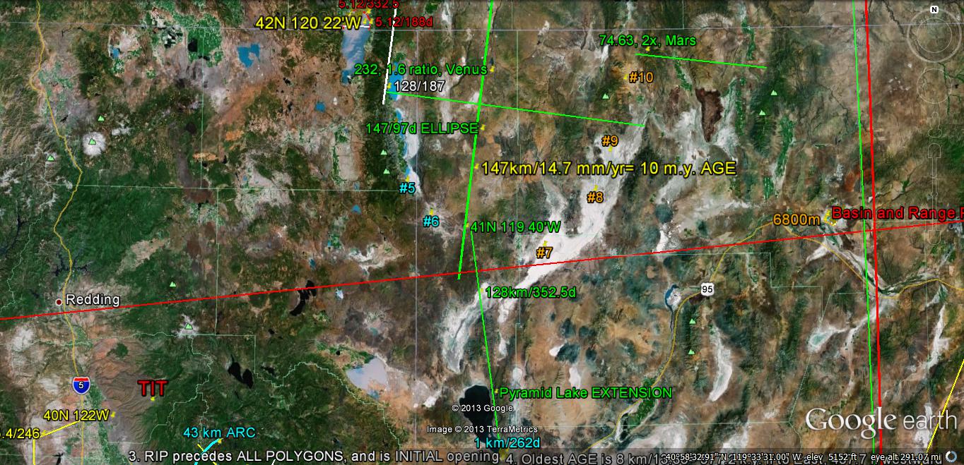
The LONGEST EXTENSION is yielding something of WORLD-WIDE VALUE; the exact 1000 meters and the 2048 meters LINEARS indicate that these result from a RAPID MOVEMENT (60 mm/year) in an E-W DIRECTION. This hints that all such LINEARS are due to PERIPHERAL FAST ROTATION about a FULCRUM! This is NOT a regional, but a LOCAL CELL ROTATION; this establishes a CRITICAL LATITUDE-LONGITUDE about which the CRITICAL TIME creates a LOCAL ANOMALY! This will have to be categorized, to establish the REPEAT-ABILITY of such triple conjunctions. This one is on a NON-SIMPLE SET of coordinates- 39 50'51"N 119 26'14.37"W, and will be compared to others in the nearby EVAPORITE BASINS (which are EXHIBITED adjacent to the NW corner of the Basin and Range province), and which is probably related to the STRING of Rhyolitic EXTRUSIONS at the ID, NV, OR, and UT borders. I will EXTRAPOLATE the WHITE LINES.
The CRITICAL TIME may be 41,000 (40,960 by BINARY THEOREM) YEARS- which is the AXIAL WOBBLE CYCLE found by Malinkovitch. This could be somewhat confirmed by the APPEARANCE of an adjacent 100,000 year cycle (102,400?). This is investigated below:


EXTRAPOLATED to adjacent Basin and Range PLAYAS:

Noted above is the NEW PRIME MERIDIAN for the extension of the Pyramid Lake EXTENSION; it does NOT TREND N-S, but is on a CRITICAL LATITUDE-LONGITUDE-TIME position (41N 119 40'W, which is 50E of the original 169 40'W NATURAL MERIDIAN (at Diomede SEPARATION). This will not fit anywhere else, since the LINEAR does NOT ORIENT N-S! However, the length indicates 41 k.y., which is a CRITICAL TIME- that of the POLAR WOBBLE CYCLE COMPLETION of Milankovitch!
I will re-draw it to orient N-S:


The extension south terminates on the CA Coast, at Santa Barbara, at a LINEAR DISTANCE of 730 km, or 45 m.y. SEPARATION. This MERIDIAN may NOT be APPROPRIATE, and I will have to investigate other EVAPORITIC BASINS:

TOTAL MAXIMUM TIME PERIOD is 53 m.y., by this METHOD, and this is OLDER than the Colorado Plateau (Paleocene), where fresh water lakes were "CROPPING UP" throughout the region after UPLIFT BEGAN.


Anaho Island is a "RISE WITHIN a sink"- which is common for ATMOSPHERIC and EARTH TIDES. These develop CONTINUALLY, and for the WEATHER, you recognoze them as a LOW PRESSURE CCW-ROTATING CELL within a COLD CW BLUE SKIES FEATURE. Normally HIGH and LOW PRESSURE CELLS exist adjacent to each other, but OCCASIONALLY they OVERLAP- yielding a STAGNATION!

Above and following PHOTOS are courtesy of USGS:

Tufa- a CaCO3 DEPOSIT- is common for the lake; it is formed by the PRECIPITATION of dissolved Ca and HCO3 ions as evaporation ensues. This is all exagerated by the GRAVITATIONAL SHEAR-ROTATION of the CRUST whenever there exists ABNORMAL STRESS around the PERIPHERY. The MAIN CLUE that this is ABNORMAL is found by measuring the distance of the FULCRUM of the Island from the LAKE WIDTH-  it is 1/4th of the width at the E-W SEPARATION:


VIEWING ATMOSPHERIC TIDES- which follow the rules for EARTH WOBBLE, ROTATION, SHEAR, and TIDAL SHIFT,S are shown in the HEMISPHERE PORTION found in a LINK printed further down:


These are REGULATED by the SHEAR and "RIP" developed by the GRAVITATIONAL HORIZONTAL-VERTICAL INFLUENCE of the Sun and Planets. Look for the ratios ASSOCIATED WITH THEM: 1.6 Venus, 2.0 Mars, and 2.5 Jupiter. There are others for Mercury, Saturn, and Uranus, but they are not SIMPLE INTEGERS, and I have to DOCUMENT them:
1.28 RATIO for Mercury, 1.6, 2.0, 2.5, 3.125, and 3.90625 for Uranus. NOTICE the MATHEMATICAL SERIES: 1.25(N1) = N2- which is a CORELLARY of the KEPLER FINDING.


I saw MIMA MOUNDS from Freeway I-5, near Roseburg, OR, and will take photos of them upon returning; they would NOT be RECOGNIZED, since they are HILL-SIZE, and Geologists have not yet understood the ones in MIMA MOUND STATE PARK WA, let alone the ones which have undergone SIGNIFICENT EROSION at their base (causing them to remain as mounds higher than TERRAIN). The MOUNDS STAND OUT, and are "TWISTED" CCW as they rise relative to the region (NOT LOCALLY); this HARDENS the sedimentary rock, eventually INITIATING SHALLOW METAMORPHISM! 
These MOUNDS-TRAPEZOIDS-LINEARS are associated with COMPRESSION- creating the CHATTER = d(JERK= d{accelleration}/dt)/dt. This is SIMILAR to IRREGULAR BACK-and- FORTH JERKING of your head, when you unevenly accelerate your auto. This changes the SIMPLE JERK to a  SINUSOIDAL CHATTER!
This ANALEMMA on the Umpqua River, at Roseburg, OR, traces a PARTIAL FIGURE 8, in an "S" shaped configuration. This infers that the northern part is RISING, while the south segment is SINKING CW. Since the water flows downhill, this is true, and we have to prove that the EASTERN CHANNEL is actually RISING NOW! This is proven, by noticing that the "TICS" and DIVIDING LINEARS are exhibited to the east. A DIVIDER SEPARATES 2 ARCS, one of which is CONVEX EASTWARD, the other WESTWARD. Between the two, the TRANSITION ZONE is subject to RAPID SHEAR- creating the "JERKS", CHATTER, and MOUNDS. 

 
Let's check all this CATEGORIZATION of LINEARS, ARCS, LENGTHS, and RATIOS at the Mid Atlantic Ridge, MAR, to determine the SEQUENCE of events with time:
 
West side of MAR moves at the NW rate (Qsna is the NW continent): 20.48, while the east side moves at the NE rate: 10.24 mm/year, so that the result is an OPENING at the MAR! These rates are only APPROXIMATE and must be made as accurate as possible to determine why the MAR ONLY EXHIBITS EXTRUSIONS OCCASIONALLY! This 10.24 mm/year difference (about 1/3rd inch) should result in an OUTPOURING of Lava somewhere, besides Iceland!
 
Below is my most careful ANALYSIS of the VARIOUS MOVEMENTS; these exhibit linears and ARCS of the RATIOS: 1.6, 2.0, 2.5- relating to the GRAVITATIONAL INFLUENCES. They may be further dissected with use of angular changes, DIVIDERS, and spreads:
I will magnify the Google earth traces as much as possible; the DETAILS ALLOW a more DEFINITIVE ANALYSIS:


STAY TUNED, since this has proven to be more fruitful than for Dry land OUTCROPS!


Friday, April 12, 2013

CHARACTERISTICS of LINES, LINEAMENTS or linears in the Pacific BASIN:


I have already found that the Atlantic Ocean exhibits a LINEAR to the EAST of the Continental Shelf and west of the Mid-Atlantic Ridge, MAR. This is shown, ORIENTED in an N-S DIRECTION as a 2048 km INCIPIENT TRANSFORM:


The Sahara, Africa exhibits a 2400 km LINEAR, yielding a 256 m.y. POLYGONAL DEVELOPMENT of a "RIP" in the CRUST, from the Atlas Mountains to the southern part of the AFRICAN BULGE! This is in a SERIES of 800 km MULTIPLES: Sierras, 800; Owen Stanley, 1600; Atlas. 2400, and 3200 km- to leave for your own WORKOUT:


The MID-ATLANTIC exhibits a CIRCULAR DEVELOPMENT of Volcanic Islands- lying on a CRITICAL LATITUDE:


Shown below is the UN-MARKED LINEAR, so that you can see this 2048 km line; I assume that it is exhibited because of the VERTICAL GRAVITATIONAL ATTRACTION- causing a "RIP" in the relatively undisturbed BASIN BASE-bottom:


From this display there are several MEASUREABLE VARIABLES:
1.    LENGTH;
2.    COMPASS BEARING from True North;
3.    Clarity, indicating RELATIVE AGE;
4.    WIDTH of the exhibit, and,
5.    DEVIATION ANGLE from ADJACENT LINEARS.
These displays require an UNDISTURBED BASIN FLOOR, where the measurements can be made, without interference from other UNKNOWN EVENTS. The first one investigated in the Pacific was near the Tonga TRENCH- which is oriented due north of the Mt. Erebus ACTIVE VOLCANO in Antarctica’s Ross Sea, on an island created by the EXTRUSIONS. This finding required that there be found a new NATURAL PRIME MERIDIAN, different from that shown for the North Pacific.


The TIDAL MOVEMENT RATES were expected to vary from those known in the North American Quadransphere, Qsna- which is 20.48 mm/year for the exact NW quadrant. This was found to be 30.72, and must be further solved for several cases, so that confidence can be attained. Difficulty arises from exhibits where there is an OBVIOUS ROTATION or spiral- which has large CIRCUMFERENTIAL RATES with near-zero at the FULCRUM, as in the case of Fiji:


Literature REFERENCES for Fiji GEOLOGY are scant, indicating that UPLIFT BEGAN in the LATE EOCENE, with VULCANISM in the Oligocene; this agrees with my calculations- which find near 30 m.y. for several NEARBY ROTATIONS. I'll use a TIDAL MOVEMENT RATE of 30 mm/yr TEMPORARILY, until finding a more accurate value from CASE HISTORIES. The Tonga TRENCH has been estimated as moving 30 cm/yr.
This TRENCH is currently being investigated by geologists, and can be expected to follow the PLATE DOGMA. Google earth will divulge the MECHANISM, and we just have to follow the CLUES!


An inquirer asked: “Why are you placing all this on the internet, when you will get NO RECOGNITION from the GEOLOGY CULTURE?” My answer is four-fold:
1.    This is a charitable donation; they need all the help that they can get, with their inability to make PREDICTIONS, EXTRAPOLATIONS, or find MECHANISMS- with their reliance on CLASSIFICATION-NOMENCLATURE as their main endeavor;
2.    They have NO TRAINING in using Physics as a base for Geology, and show no interest in learning how GRAVITATION influences the DYNAMICS of the EARTH’S CRUST;
3.    They have a STIFF RESISTANCE to my findings, because after all, THEIR OX is getting GORED; and,
4.    They have extreme difficulty in discarding all their FRUSTRATED EFFORTS in trying to make use of HOTSPOTS, MANTLE PLUMES and constantly-having-to-be-ADJUSTED PLATES.